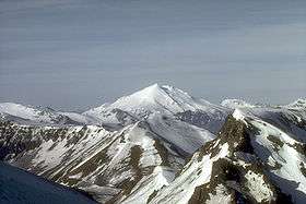
Mount Dutton
| Mount Dutton | |
|---|---|
 Mount Dutton lies 14 km (9 mi) north of the community of King Cove on the Alaska Peninsula | |
| Highest point | |
| Elevation | 4,941 ft (1,506 m) |
| Listing | Mountain peaks of Alaska |
| Coordinates | 55°10′05″N 162°16′19″W / 55.168°N 162.272°WCoordinates: 55°10′05″N 162°16′19″W / 55.168°N 162.272°W |
| Geography | |
| Location | Alaska Peninsula, Alaska, U.S. |
| Parent range | Aleutian Range |
| Geology | |
| Mountain type | Stratovolcano |
| Volcanic arc/belt | Aleutian Arc |
| Last eruption | Unknown |
Mount Dutton is a stratovolcano in the Aleutian Range of the U.S. state of Alaska, on the Alaska Peninsula.
Geography
Dutton lies just short of 9 miles (14 km) from King Cove, a fishing headquarters for the locality.[1]
Geologic activity
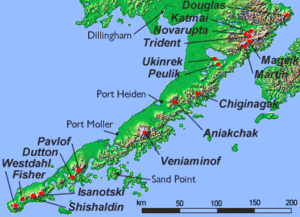
Map showing volcanoes of Alaska Peninsula.
Dutton is a highly glaciated volcano. Its summit is composed of a series of lava domes which form a complex stratovolcano. The mountain's recent history is marked by at least avalanche which removed andesitic lava flows and several lava domes from the flank of its body and swiftly cascaded westward and southward towards Belkofski Bay.[1]
Between 1984 and 1985, a series of earthquake swarms took place in the volcano's vicinity.[1] Another swarm took place in the summer of 1988.[2]
See also
References
- 1 2 3 "Dutton". Global Volcanism Program. Smithsonian Institution. Retrieved April 17, 2011.
- ↑ "Dutton: Index of Monthly Reports". Global Volcanism Program. Smithsonian Institution. Retrieved April 17, 2011.
Sources
- "Dutton". Global Volcanism Program. Smithsonian Institution.
- Volcanoes of the Alaska Peninsula and Aleutian Islands-Selected Photographs
- Alaska Volcano Observatory
This article is issued from Wikipedia - version of the 1/2/2016. The text is available under the Creative Commons Attribution/Share Alike but additional terms may apply for the media files.