Cockayne, North Yorkshire
| Cockayne | |
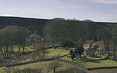 The hamlet includes a small church, and Bransdale Lodge |
|
 Cockayne |
|
| OS grid reference | SE620984 |
|---|---|
| Civil parish | Bransdale |
| District | Ryedale |
| Shire county | North Yorkshire |
| Region | Yorkshire and the Humber |
| Country | England |
| Sovereign state | United Kingdom |
| Post town | YORK |
| Postcode district | YO62 |
| Dialling code | 01751 |
| Police | North Yorkshire |
| Fire | North Yorkshire |
| Ambulance | Yorkshire |
| EU Parliament | Yorkshire and the Humber |
| UK Parliament | Ryedale (2005) Thirsk and Malton (c.2009) |
Coordinates: 54°22′41″N 1°02′42″W / 54.378°N 1.045°W
Cockayne is a hamlet in North Yorkshire, England. It is the largest settlement in the civil parish of Bransdale, in the North York Moors national park. The nearest towns are Helmsley (9 miles, 14 km) and Kirkbymoorside (10 miles, 16 km.)
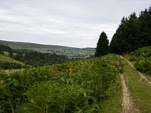
The Cleveland Way long distance footpath crosses the northern end of Cockayne Ridge, which rises above the hamlet to the north, reaching a summit of 441 m at Cockayne Head. The settlement, under the southern tip of the ridge, is a mere 225 m above sea level, according to the Ordnance Survey. Cockayne is at the head of Bransdale, a southward facing valley cut into the moors.
Bransdale Lodge (or Cockayne Lodge) is a house built in the mid 19th century[1] and once used by the Earl of Feversham as a shooting lodge.[2] The small church of St Nicholas was built about 1800 as a chapel of ease in the ancient parish of Kirkby Moorside.[3]
The hamlet is, with the exception of the Church and Glebe, entirely owned by the National Trust. The overwhelming part of the 1925 acre Bransdale estate was transferred to the National Trust through National Land Fund procedures in 1972 and comprises all the farmland and a small amount of woodland in the valley.

References
- ↑ Historic England. "Details from image database (328848)". Images of England.
- ↑ William Page (editor) (1914). "Parishes: Kirkby Moorside". Victoria County History. A History of the County of York North Riding: Volume 1. Institute of Historical Research. Retrieved 21 August 2014.
- ↑ Historic England. "Details from image database (328849)". Images of England.