Cobden, New Zealand
| Cobden | |
|---|---|
 | |
| Basic information | |
| Local authority | Greymouth |
| Population | 1,707 (2006) |
| Surrounds | |
| Northeast | Runanga |
| South | Greymouth centre |
| Southwest | Blaketown |
| West | (Tasman Sea) |
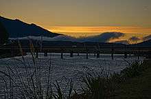
Bridge between Cobden and Greymouth centre
Cobden is a suburb to the north of Greymouth on the West Coast of New Zealand. The Grey River separates Cobden from the rest of Greymouth. To the north is the Rapahoe Range, also called the Twelve Apostles Range. State Highway 6 skirts the south-eastern edge of Cobden.[1][2]
The population was 1,707 in the 2006 Census, an increase of 30 from 2001.[3]
During the period, 1853 to 1876, Cobden was administrated as part of the Nelson Province.
Education
Cobden School is a coeducational full primary (years 1–8) school with a decile rating of 2 and a roll of 142.[4]
References
- ↑ Peter Dowling (editor) (2004). Reed New Zealand Atlas. Reed Books. pp. map 69. ISBN 0-7900-0952-8.
- ↑ Roger Smith, GeographX (2005). The Geographic Atlas of New Zealand. Robbie Burton. pp. map 148. ISBN 1-877333-20-4.
- ↑ Quickstats about Cobden
- ↑ "Te Kete Ipurangi - Cobden School". Ministry of Education.
Coordinates: 42°26′20″S 171°12′34″E / 42.4388°S 171.2094°E
This article is issued from Wikipedia - version of the 11/14/2016. The text is available under the Creative Commons Attribution/Share Alike but additional terms may apply for the media files.