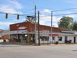
Clio, Alabama
| Clio, Alabama | |
|---|---|
| City | |
 | |
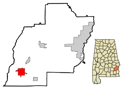 Location in Barbour County and the state of Alabama | |
| Coordinates: 31°42′35″N 85°36′24″W / 31.70972°N 85.60667°W | |
| Country | United States |
| State | Alabama |
| County | Barbour |
| Area | |
| • Total | 10.1 sq mi (26.1 km2) |
| • Land | 10.1 sq mi (26.1 km2) |
| • Water | 0 sq mi (0 km2) |
| Elevation | 525 ft (160 m) |
| Population (2010) | |
| • Total | 1,399 |
| • Density | 139/sq mi (53.7/km2) |
| Time zone | Central (CST) (UTC-6) |
| • Summer (DST) | CDT (UTC-5) |
| ZIP code | 36017 |
| Area code(s) | 334 |
| FIPS code | 01-15640 |
| GNIS feature ID | 0157921 |
Clio is a city[1] in Barbour County, Alabama, United States. The population was 1,399 at the 2010 census,[2] down from 2,206 in 2000, at which time it was a town. It is the birthplace of former Alabama governor George C. Wallace, as well as Baseball Hall of Famer and current Atlanta Braves broadcaster Don Sutton.
Geography
Clio is located in southwestern Barbour County at 31°42′36″N 85°36′24″W / 31.71000°N 85.60667°W (31.709922, -85.606708).[3]
According to the U.S. Census Bureau, the city has a total area of 10.1 square miles (26.1 km2), of which 0.008 square miles (0.02 km2), or 0.09%, is water.[2]
Demographics
| Historical population | |||
|---|---|---|---|
| Census | Pop. | %± | |
| 1900 | 326 | — | |
| 1910 | 580 | 77.9% | |
| 1920 | 838 | 44.5% | |
| 1930 | 867 | 3.5% | |
| 1940 | 841 | −3.0% | |
| 1950 | 840 | −0.1% | |
| 1960 | 929 | 10.6% | |
| 1970 | 1,065 | 14.6% | |
| 1980 | 1,224 | 14.9% | |
| 1990 | 1,365 | 11.5% | |
| 2000 | 2,206 | 61.6% | |
| 2010 | 1,399 | −36.6% | |
| Est. 2015 | 1,529 | [4] | 9.3% |
| U.S. Decennial Census[5] 2013 Estimate[6] | |||
As of the census[7] of 2010, there were 1,399 people, 514 households, and 321 families residing in the town. The population density was 139 people per square mile (53.7/km2). There were 634 housing units at an average density of 62.7 per square mile (24.3/km2). The racial makeup of the town was 36.5% Black or African American, 32.0% White, 0.4% Native American, 0.5% Asian, 0.1% Pacific Islander, 30.2% from other races, and .4% from two or more races. 36.0% of the population were Hispanic or Latino of any race.
There were 514 households out of which 28.8% had children under the age of 18 living with them, 35.4% were married couples living together, 19.8% had a female householder with no husband present, and 37.5% were non-families. 30.9% of all households were made up of individuals and 12.7% had someone living alone who was 65 years of age or older. The average household size was 2.72 and the average family size was 3.37.
In the town the population was spread out with 26.2% under the age of 18, 12.9% from 18 to 24, 26.6% from 25 to 44, 22.4% from 45 to 64, and 11.8% who were 65 years of age or older. The median age was 31.8 years. For every 100 females there were 95.7 males. For every 100 females age 18 and over, there were 85.4 males.
The median income for a household in the town was $21,806, and the median income for a family was $33,438. Males had a median income of $32,908 versus $25,625 for females. The per capita income for the town was $8,722. About 28.3% of families and 28.0% of the population were below the poverty line, including 33.1% of those under age 18 and 19.1% of those age 65 or over.
Notable people
- McDowell Lee, member of the Alabama House of Representatives and Mayor of Clio.
- George Corley Wallace, Four-term Governor of Alabama and four-time candidate for U.S. President.
- Donald Howard (Don) Sutton, Major League Baseball Hall of Famer.
- Elton Bryson Stephens, Sr., Founder of EBSCO Industries.
Points of interest
Gallery
-

Clio Heritage Mural
-
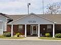
Clio Town Hall
-

Clio Post Office (ZIP Code: 36017)
References
- ↑ U.S. Census change list Archived August 6, 2010, at the Wayback Machine.
- 1 2 "Geographic Identifiers: 2010 Demographic Profile Data (G001): Clio city, Alabama". U.S. Census Bureau, American Factfinder. Retrieved September 16, 2013.
- ↑ "US Gazetteer files: 2010, 2000, and 1990". United States Census Bureau. 2011-02-12. Retrieved 2011-04-23.
- ↑ "Annual Estimates of the Resident Population for Incorporated Places: April 1, 2010 to July 1, 2015". Retrieved July 2, 2016.
- ↑ "U.S. Decennial Census". Census.gov. Archived from the original on May 11, 2015. Retrieved June 6, 2013.
- ↑ "Annual Estimates of the Resident Population: April 1, 2010 to July 1, 2013". Retrieved June 3, 2014.
- ↑ "American FactFinder". United States Census Bureau. Archived from the original on 2013-09-11. Retrieved 2008-01-31.
Coordinates: 31°42′36″N 85°36′24″W / 31.709922°N 85.606708°W
Municipalities and communities of Barbour County, Alabama, United States | ||
|---|---|---|
| Cities | 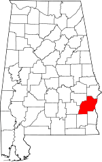 | |
| Towns | ||
| Unincorporated communities | ||