Cleland, North Lanarkshire
| Cleland | |
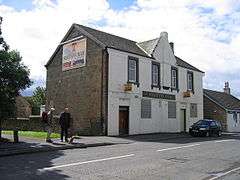 Station Bar in Cleland |
|
 Cleland |
|
| Population | 2,806 (2001 Census) |
|---|---|
| OS grid reference | NS7958 |
| Council area | North Lanarkshire |
| Lieutenancy area | Lanarkshire |
| Country | Scotland |
| Sovereign state | United Kingdom |
| Post town | Motherwell |
| Postcode district | ML1 |
| Dialling code | 01698 |
| Police | Scottish |
| Fire | Scottish |
| Ambulance | Scottish |
| EU Parliament | Scotland |
| UK Parliament | Motherwell and Wishaw |
| Scottish Parliament | Motherwell and Wishaw |
Coordinates: 55°48′08″N 3°54′51″W / 55.80234°N 3.91427°W
Cleland is a small village near Motherwell and Wishaw, North Lanarkshire, Scotland. The village has a strong coal mining heritage, and is a typical example of a working class village in North Lanarkshire and the Glasgow area. Due to its location, despite being at the heart of North Lanarkshire, the village is very much removed, geographically and culturally, from surrounding towns such as Motherwell, Shotts and Wishaw.
Geography
Geographically, the village of Cleland is roughly bounded by the junction of Cleland Road and Chapleknowe road (B7029) to the west, the junction of Biggar Road and the B7033 Newhouse to the North, the junction of Bellside Road and Carlisle Road (A73) to the East and the junction of Swinstie road and Wishaw high road to the south.
Present
The modern village consists of three main areas:
- Centre
- Parkside: hill area located next to the main area of Cleland. Windyedge is a new housing scheme in Parkside
- Bellside: from Cleland railway station out towards A73 dual carriageway. New housing developments include Captain's Walk and Bellside Brae
Both the Glen Noble and the Calder Mains area recent housing developments adjacent to the Main Street. Cleland falls under Murdostoun Community Policing Team.[1]
The centre of Cleland has a collection of retail shops, presently including branches of Londis and Scotmid. There is also a butcher, a fruit and vegetable shop, a florist, a garage, some take aways and a branch of the Royal Bank of Scotland. There is also a library.[2]
There are three churches, Saint Mary's Roman Catholic,[3] the Church of Scotland,[4] and Cleland Baptist Church.[5]
The Cleland Club is the former miners Working men's club, now used by the wider community. Kelly's bar is the home of local supporters of Celtic, and there are two further public houses.
Schools
Cleland is served by two primary schools. St. Mary's is the larger of the two schools with a roll of around 140 (excluding nursery),[6] compared with Cleland Primary's roll of around 90.[7] St Mary's Primary School also includes the nursery which is non-denominational.
The two senior schools which serve the community are Taylor RC High School in New Stevenston,[8] and Coltness High School near Wishaw.[9]
Transport
Cleland is situated within close proximity to the M8 motorway, offering road connections to Glasgow and Edinburgh, between and beyond. It is 6 miles (10 km) from the M74 motorway, offering road connections to England and the M6 motorway.
Cleland railway station is situated on Bellside Road and is a stop on the Glasgow - Edinburgh via Shotts Line. It is around a 30-minute journey to Glasgow and an hour to Edinburgh. The trains run every day with a limited service on Sundays.[10][11]
Several bus services operate into Glasgow, Wishaw, Motherwell and the surrounding areas.
Representation
Cleland is in the Scottish parliamentary constituency of Motherwell and Wishaw,[12] in the Scottish Parliament Region of Central Scotland.[13] The current Member of the Scottish Parliament is Clare Adamson of the Scottish National Party.
Cleland's is also in the UK Parliament constituency of Motherwell and Wishaw, and is represented by Marion Fellows of the Scottish National Party.
Cleland falls under Ward 19 Murdostoun of North Lanarkshire Council.[14] Cleland's councillor is James "Jimmy" Martin.[15]
Cleland timeline
- "Historic Notices and Domestic History of the Parish of Shotts”, by William Grossart, published by Aird and Coghill in 1880 (copy available in North Lanarkshire Heritage Centre).
- “Old Newmains and the Villages Around Wishaw”, by Lewis Hutton, published by Stenlake Publishing in 1999 (copy available in North Lanarkshire Heritage Centre). This book also has 11 photographs of Cleland from around 1900, including Omoa Square, Omoa Road (showing horse carriages), Main Street at Cleland Cross and at the Post Office, Bellside Road, Aldersyde/ Biggar Road and Fraser Street in Parkside, and Omoa Poorhouse.
- "Images of Scotland: Wishaw", Compiled Helen Moir, Published by Tempus Publishing Limited (copy available in North Lanarkshire Heritage Centre). This has one photograph of Cleland - a photograph of Chassels Old Castle Bar (what is now Kelly's Bar) from around 1905.
- The Wishaw Herald (microfilm available in North Lanarkshire Heritage Centre).
- The Wishaw Press and Advertiser (microfilm available in North Lanarkshire Heritage Centre).
- Ordnance Survey Old Maps[16]
- The Scottish Pottery Society[17]
- Scottish Mining[18]
- Scran[19]
- RailScot Railway History
- The National Archives of Scotland[20]
- The National Library of Scotland[21]
- The Workhouse[22]
- Statistical Accounts of Scotland: 1791–1799; and 1843-45[23] (From the menu option: Choose from county lists: Lanark; then Choose report: Bertram Shotts)
- "A Musical History of Shotts" (copy available in North Lanarkshire Heritage Centre).
- "Lanark's Mining Industry in 1896 - A List of Coal Mines" from Peak District Mines Historical Society Ltd[24]
Timeline 1296: The first Cleland on record is Alexander Cleland of that Ilk who married a cousin of Sir William Wallace. Their son, James Cleland joined William Wallace in battle in 1296 at Loudonhill; at Stirling in 1297; Falkirk in 1298; Glasgow in 1300; and in France in 1301. James Cleland and his son John Cleland fought at Bannockburn in 1314. For his loyalty and good service, Robert the Bruce gave James Cleland the lands of Calder-clere, now East Calder.
1450: The Cleland line later extends down to James Cleland, son of William Cleland of that Ilk. James marries a Lord Somerville’s daughter in 1450, and their line branches out to be the Clelands of Faskin, Monkland and Gartness.
The Cleland family lands were therefore a number of areas which included current day Cleland village. There was no defined village of Cleland as it is known today. Rather there was a Cleland House where the Cleland family lived, and the land where present day Cleland stands was part of the Cleland family’s estate.
1478: Langbyre, Wyndyegis, Knochkublis farms (now Langbyre near Bellside, Windyedge in Parkside, Knowenoble in Cleland) discussed in rent accounts for James, Lord Hamilton.
c. 1596: Timothy Pont produces a map of Scotland, clearly showing what is now Lanarkshire, with the places of Kneeland and Kneelandtoun (see the National Library of Scotland).[25]
Kneeland is an olde alternative name for the Cleland family surname. Over time, Kneeland would eventually become Cleland (and Cleland used to be pronounced as Clee-land in the same way as Knee-land).
1702: Alexander Cleland of Cleland finds himself in debt and sells the Cleland Estate to William and Archibald Hamilton.
1711: William and Archibald Hamilton sell Cleland Estate to Gavin Hamilton of Inverdovat. The link between the Cleland families and the Cleland lands is therefore broken. The sale of the Estate was described as follows:
All and Haill the lands Clelandtoun, called the five pund land of Clelandtoun with the tower and fortalice, &c. – in the barony of Bothwell – All and Haill the fortie shilling land of Little Hareshaw, in the parish of Shotts – All and Haill the lands of Newarthill and Whitagreen – All and Haill the Mains and Mill of Carphinc- Excepting threfra the feu ferm rights if Little Hareshaw.
1755: A map for General Roy’s expeditions into Jacobite Scotland shows Cleland Toun.[26]
1763: First colliery in what is present day Cleland is in operation at Swinstie.
1766: Alexander Inglis Hamilton of Murdoston sells Cleland Estate to Captain Hew Dalrymple of Fordal.
1789: Colonel William Dalrymple (the second son of Sir William Dalrymple, third baronet of Cousland, and the nephew of Captain Hew Dalrymple), distinguishes himself by helping to capture both the Fort of San Fernando de Omoa and the port town of Omoa, in Honduras, Central America (see William Dalrymple (British Army officer) and Battle of San Fernando de Omoa).
1797–1866: Omoa Iron Works is erected on Cleland estate by Colonel William Dalrymple on returning to civilian life. Colonel Dalrymple’s uncle, Hew, left him the Fordal estate in Mid-Lothian, and Cleland estate in Bothwell and Shotts parishes.
At first there was only one furnace at Omoa, employing about 40 miners, 40 smelters and other workmen, and 12 horses. The furnace consumed nine tons of calcined ironstone per day, with casts every eighteen hours, yielding about two tons of pig-iron each cast.
Omoa claimed to be the second oldest iron works in Scotland (to Wilsontown). Originally prospering enough to create the new community of Omoa Town, the Omoa Works suffered a downturn through several changes in ownership and a slump in trade following the outbreak of Civil War in America in 1861. Omoa Works would change proprietors several times, the last being to Robert Stewart, Esq., of Murdoston. Shortly after the death of Robert Stewart in 1866 (see later), operations ceased, with the furnaces eventually becoming ruins.
The procurement of ironstone for the Iron Works was reported as follows:
An interesting circumstance connected with the early history of Omoa, and perhaps applicable to other iron-works at the same period, was the scarcity of ironstone and how it was procured. Any balls found in a stream, or cropping-out by its margin, were carefully collected, and in the case of Omoa, ironstone was collected in streams or otherwise by farmers and others in the neighbourhood, and taken to the ironworks and sold - many a ton went from Shotts parish in this way. The transaction was never called in question, but if practised at the present day, would be called thieving.
1802: Shotts Ironworks is established by a company of private gentlemen, under the control of Mr. John Baird, as managing partner, for upwards of 40 years. The manager, Mr. Ormiston, is noted as having introduced many improvements.
Connected with the works was an extensive foundry which was long celebrated for its superior castings, and was one of the few places in Scotland for the making of tinned hollow ware.
The coal works in the parish at the time were numerous. In the south-west, from Knowenoble to Greenhill and Linrig, the highest beds in the section were wrought, but these did not extend to other parts of the parish. They were mostly thick-bedded coals, and consist of the “Ell” in small patches, the “Main” and the “Splint” Coals. Also large fields of “Virtuewell” which was also found in other parts of the parish. For the working of coal works, pits were sunk on the lands of Knowenoble, Longbyers, Spindleside, Knowenoblehill, Windyedge, Greenhill, Linrig, and other places. The supply from these was exhausted after a few years. There was a good black-band ironstone, six inches (152 mm) thick, wrought at Bellside and Greenhill, but confined to these localities, and nearly all wrought. In the district large fields of Drumgray coal was still to be worked, and only partially wrought at Greenhill, Little Hareshaw, North Linrig, and Peatpots.
1810–1866: Robert Stewart.[27] On the death of his father, who for several years had carried on the business of an iron and coal master at Omoa on the estate of Cleland, belonging to the family of Stair, Robert Stewart reconstructed the works, and acquired a lease to an extensive mineral field, which was found to contain an excellent seam of blackband ironstone, he in the course of a few years acquired a considerable fortune, to which after years of great success were to make great additions.
He became a member of Glasgow Town Council in 1842, becoming Lord Provost, 1848–1854, and drove the initiative to supply Glasgow with a freshwater supply from Loch Katrine. In 1856 Mr. Stewart acquired from Mr. Baillie Cochrane, now Lord Lamington, at a cost of £55,000, the estate of Murdostoun, situated in the parish of Shotts, Lanarkshire, and immediately began to improve it upon an extensive scale. This property belonged down to the middle of the fifteenth century to the Scotts of Buccleuch, and was then exchanged by them for part of the lands of Branxholme in Roxburghshire, belonging to a family of the name of Inglis.
In later times Murdostoun belonged to James Inglis Hamilton, who commanded the Scots Greys at Waterloo, and who was killed at the head of his regiment in the somewhat reckless charge which our heavy cavalry made on Marshal Ney's “grand battery.” It then passed to Admiral the Hon. Sir Alexander Inglis Cochrane, captor of the Danish West India Islands, and next, in 1832, to his son the late Admiral Sir Thomas Inglis Cochrane, the father of Lord Lamington. This estate Mr. Stewart added to in 1865 by the purchase of the lands of Langbyres, situated in the vicinity of Murdostoun.
1813: The Omoa Waggonway is opened from Newarthill collieries to Omoa Iron Works by Col. Dalrymple.
1837: The Coltness Iron Company is established in Newmains by Henry Houldsworth.
It was estimated that the 2,000-acre (8.1 km2) site at Newmains on Coltness Estate could produce 18,000 tons of coal and 1,000 tons of ironstone per acre. Henry Houldsworth had no difficulty, therefore, in attracting experienced labour from the iron works of Yorkshire as well as from Omoa and Wilsontown in Lanarkshire.[28]
The Iron Company, needing coal, was also aware of the coal mines in Ireland. When coal was being mined in Shotts, Cleland and the surrounding areas, the Iron Company sent representatives over to Ireland to hire miners for the Scottish mines. This is a primary reason why so many Irish families came to Shotts, Omoa, etc. Many came from County Donegal, and the Castlecomer coal fields in what is now north County Kilkenny/ south County Laois.
1861: Omoa and Cleland population of 1233: Cleland has 190 males and 175 females; Omoa has 509 males and 359 females.
1864: 25 June. Omoa Iron Works Brass Band competed at Brass Band Competition, College Green, Glasgow.
1868: The Omoa Iron Works closes, two years after the death of its penultimate Owner, Robert Stewart of Murdostoun (Murdostoun Castle being near Bellside in Cleland).
1869: Omoa and Midcalder Line (Caledonian Railway) is opened.
Note that Cleland would be served with two railway stations. The first station was Omoa Station (across from what is now Cleland Hospital), and the second was Cleland Station (behind what is now Cleland Cross). After Cleland Station was closed, Omoa Station was then renamed Cleland Station.
1869: List of mines (under Holytown) includes Cleland Collieries owned by Wm. Dixon, Monkland Iron Co., Trustees of late Robert Stewart; Wyndedge owned by Robert Dick.
1870: Omoa Fireclay Works (brickworks) opens.
1871: Omoa/ Cleland population of 819.
1876: Cleland and Omoa Public School opens.
1877: St Mary’s Roman Catholic Church, a Free Church and a Chapel of Ease are established.
1881: Omoa/ Cleland population of 1626.
1881: St. Mary’s Roman Catholic Church presbytery is built, designed by Messrs Peyin.
1882: Omoa and Midcalder Line (Caledonian Railway) Addiewell is opened.
1885: The “Ordnance Gazetteer of Scotland” states:
Cleland, a village of N Lanarkshire, chiefly in Shotts parish, but also partly in Bothwell. With a station on the Morningside branch of the Caledonian, it stands near the left bank of South Calder Water, 3¾ miles ESE of Holytown, 7 E of Bothwell village, and 3½ E by N of Motherwell, under which it has a post office. It mainly depends on the large neighbouring collieries of the Omoa and Cleland Coal and Iron Company; at it are an Established chapel of ease (1877), a Free church, and St Mary's Roman Catholic church (1877), to the last of which, designed by Messrs Peyin, a presbytery was added in 1881. Cleland and Omoa public school and Cleland Roman Catholic school, with respective accommodation for 300 and 254 children, had (1880) an average attendance of 199 and 240, and grants of £190, 7s. 2d. and £182. Pop. (1861) 1233, (1871) 819, (1881) 1626.
As the Gazetteer suggests, Omoa and Cleland were separate villages, and parts of Omoa and Cleland villages came under the District of West Shotts, and the remainder came under the District of Bothwell (a point to note when searching for Census information). However, both were within the Parish of Cleland.
1889–1915: Omoa Greenhill Works brickworks opens (R. Young Greenhill).
1895–1911: Cleland Pottery opened (across the small "gorge" from the swingpark off Lithgow Drive/ Chapel Street). It later closed down in 1911.[29][30]
1896: The coal mines in Lanark listed in "Tables compiled by J.B. Atkinson, H.M. Inspector for the East Scotland District in his Report for 1896" is provided by Peak District Mines Historical Society Ltd.[24] For Cleland and Omoa, the list includes: Beggarford, Omoa owned by Robert Young's Trustees, Greenhill, by Holytown; Brownhill, Cleland owned by Barr and Higgins, 75, Bothwell St., Glasgow; Greenhill, Omoa owned by Robert Young's Trustees, Greenhill, by Holytown; Hareshaw, Omoa owned by Hareshaw Coal Co., Cleland; Knownoble, Cleland owned by Kerr and Mitchell, Glencleland, Wishaw; Knownoblehill, Cleland owned by Robert Dick, Cleland; Murdostoun Cleland owned by John McAndrew and Co., Cleland; Sunnyside, Cleland owned by Coltness Iron Co. Ltd., Newmains.
1901: The 1901 Census takes place. The 1901 Census for Omoa and Cleland can be viewed for free at Motherwell Heritage Centre, and prints of pages can be purchased. Alternatively, ScotlandsPeople can be searched - but to search and purchase from ScotlandsPeople is relatively more difficult and expensive than going to Motherwell Heritage Centre.
Note that the area of Omoa comes under the Village of Omoa, Quoad Sacra Parish of Cleland, Part Parish Ward of West Shotts, Civil Parish of Shotts, School Board District of Shotts and Parliamentary Division of North East Lanark. This Shotts connection sometimes misleads people researching Omoa and Omoa Square, as they look towards the village of Shotts today, rather than Omoa in the Parish of Cleland, in the District of Shotts from the past.
1905: Cleland Poorhouse opens.[31]
1906: Cleland streets named and numbered. For information: when later built, Lithgow Drive would be named after Dr Lithgow, and Gibb Street would be named after the mid-wife Mrs Gibb, who both served Omoa and Cleland.
1910: The Annual Report of the County & District Medical Officer for Lanarkshire, 1910, describes Omoa Square:
This group of 114 single-apartment and 24 two-apartment houses, is situated in the Parish of Shotts. These houses were inspected by the Committee on 27 September, and have since been the subject of considerable correspondence and several meetings. A specification, showing the repairs necessary to make the houses reasonably fit for human habitation, was prepared and submitted to the proprietors' agents, who replied that the suggestions were extremely expensive and far beyond any reasonable requirement, and asking a meeting at the property. At this meeting the proprietor was strongly urged to provide domestic and sanitary conveniences of an approved type for the front one-storey block as an experiment in the first instance, but his agent objected very strongly to these proposals, on the ground that the expense was not warranted and the class of tenants would not make proper use of the conveniences. He, however, promised to consider the matter further. No definite proposals were put forward for the improvement of the housing conditions, and to facilitate matters I was afterwards instructed by the Committee to submit a Representation under the Housing Acts. [reproduced from http://www.scottishmining.co.uk/41.html]
"The Housing Condition of Miners" Report by the Medical Officer of Health, Dr John T. Wilson, 1910, summarises the Square as:
Originally built by Omoa Iron and Coal Co, but now privately owned. The houses are occupied by miners employed at Cleland, Howmuir, Westwood, Murdostoun and quarrymen employed at Auchinlea – 114 houses of one apartment, rental, £5 4s. and £6 10s; and 24 houses of two-apartments, rental £7 16s and £10 8s – one story, brick – erected about 70 years ago – no damp -roof course – plastered on solid – brick floors, some floors cement – internal surfaces of walls and ceilings irregular, broken and patched – walls mostly damp – several houses unoccupied. No overcrowding – apartments large. No gardens – one wash house in centre of square – coal cellars recently erected for each house, but many have been broken down by tenants. 7 privy midden, in centre of square, in rear and in front, at distances of 20 feet (6.1 m) to 30 yards (27 m); doors and windows of these have been destroyed. No sinks – drainage by surface channels. Gravitation water from standpipes in centre and back of square, from 2 to 10 yards (1.8 to 9.1 m) distant. These houses have been frequently inspected, and sanitary improvements have been carried out with no satisfactory results. Notes on Omoa Square - Closing order made under Section 17 of Housing &c Act, 19. Partly demolished. [reproduced from http://www.scottishmining.co.uk/237.html]
By 1910, the Square’s houses were semi-abandoned and considered not properly fit for human habitation, with a recommendation for demolition. See “Old Newmains and the Villages Around Wishaw”, by Lewis Hutton, for a photograph of the outside of Omoa Square around 1900.
1920–1947: Auchinlea Brickworks opens/ closes.
1920–1930: Hardship means many Cleland families leave for other mining areas or emigrate to America and Canada. Search Ellis Island records for free, and view electronic scans of ship manifests which include many Cleland families arriving in New York.
1920s-30s: Recollections of Cleland in the late 1920s and 1930s by Anthony Brown is provided at his family website,[32] and recalls some of the Omoa and Cleland families from that period.
1930: The latest census taken in Cleland by the police shows a reduction in the population of 552 compared with the census taken in 1928. The total population now is 4274, made up of 2240 males and 2030 females.
1930: Wishaw and Coltness Railway Newmains to Cleland Junction is closed to freight.
1930: Wishaw and Coltness Railway Morningside to Holytown (Cleland Junction) is closed to passengers.
1930: What is now Cleland Station collapses, due to a local mine running under it caving in. It requires major repairs before re-opening.
1934: Cleland War Memorial erected after public subscription, to the memory of the men of Cleland and District who fell in the Great War 1914–1918.[33][34]
1934-35: Electricity comes to Cleland.
1935: Cleland Public Park opened, to celebrate the Silver Jubilee of King George V in May 1935.
1939: Recollections of Cleland during World War II by Joseph J Brown is provided at the BBC's Scotland on Film website.[35]
1966: Airdrie and Newhouse Line (Caledonian Railway) Chapelhall to Bellside junction is closed.
1986: Cleland (previously Omoa) and Midcalder Line (Caledonian Railway) Polkemmet Colliery line lifted.
People from Cleland
- For a full list, see Category:People from Cleland, North Lanarkshire
References
- ↑ "Welcome to the Police Scotland website - Police Scotland". Strathclyde.police.uk. 2013-04-01. Archived from the original on 2012-03-01. Retrieved 2015-05-09.
- ↑ "North Lanarkshire Council - Cleland Library". Northlanarkshire.gov.uk. 2014-10-30. Archived from the original on 2015-04-22. Retrieved 2015-05-09.
- ↑ "Diocese of Motherwell". Rcdom.org.uk. Retrieved 2015-05-09.
- ↑
- ↑ "Cleland Baptist Church". Cleland Baptist Church. Archived from the original on 2015-06-22. Retrieved 2015-05-09.
- ↑ "North Lanarkshire Council - St Mary's Primary and Nursery Cleland". Northlanarkshire.gov.uk. 2014-07-30. Retrieved 2015-05-09.
- ↑ "North Lanarkshire Council - Cleland Primary". Northlanarkshire.gov.uk. 2014-07-30. Retrieved 2015-05-09.
- ↑ "North Lanarkshire Council - Taylor High". Northlanarkshire.gov.uk. 2014-07-30. Retrieved 2015-05-09.
- ↑ "North Lanarkshire Council - Coltness High". Northlanarkshire.gov.uk. 2015-02-24. Retrieved 2015-05-09.
- ↑ "Glasgow - Edinburgh via Shotts". ScotRail. Archived from the original on 2012-05-29. Retrieved 2012-06-02.
- ↑ Archived February 15, 2012, at the Wayback Machine.
- ↑
- ↑
- ↑ Archived November 9, 2009, at the Wayback Machine.
- ↑ ": Committee Information :: Members :". Councillors.northlanarkshire.gov.uk. Retrieved 2015-05-09.
- ↑ "the online repository of historic maps - home page". Old-Maps.co.uk. 1970-01-01. Retrieved 2015-05-09.
- ↑ "The Scottish Pottery Society". Scottishpotterysociety.co.uk. Retrieved 2015-05-09.
- ↑ "Home - Scottish Mining Website". Scottishmining.co.uk. 2015-02-28. Retrieved 2015-05-09.
- ↑ "Welcome to". Scran. 1998-01-05. Retrieved 2015-05-09.
- ↑ "The National Archives of Scotland Home Page". Nas.gov.uk. Archived from the original on 1970-01-01. Retrieved 2015-05-09.
- ↑ "Timothy Pont's Maps". Nls.uk. Retrieved 2015-05-09.
- ↑ Archived June 5, 2011, at the Wayback Machine.
- ↑ "The Statistical Accounts of Scotland:". Stat-acc-scot.edina.ac.uk. Retrieved 2015-05-09.
- 1 2 "Peak District Mines Historical Society Ltd". Pdmhs.com. Retrieved 2015-05-09.
- ↑ Archived February 11, 2012, at the Wayback Machine.
- ↑ "Copy of General Roy Map, 1755". Scran. 1998-01-05. Retrieved 2015-05-09.
- ↑ "Memoirs and portraits of 100 Glasgow men: 87. Robert Stewart [ebook chapter] / James MacLehose, 1886". Gdl.cdlr.strath.ac.uk. Retrieved 2015-05-09.
- ↑ "Location of ironworks in southern Scotland". Scran. 1998-01-05. Retrieved 2015-05-09.
- ↑ Archived November 21, 2008, at the Wayback Machine.
- ↑ "Image of pottery : Wm. Farmer & Sons" (JPG). Scottishpotterysociety.co.uk. Retrieved 2015-05-09.
- ↑ Peter Higginbotham. "The Workhouse in Omoa, Lanarkshire". Workhouses.org.uk. Retrieved 2015-05-09.
- ↑ "Anthony-M-Brown - User Trees - Genealogy.com". Familytreemaker.genealogy.com. Retrieved 2015-05-09.
- ↑ Archived July 25, 2008, at the Wayback Machine.
- ↑
- ↑ "Scotland on Film - Forum". BBC.co.uk. Retrieved 2015-05-09.
External links
| Wikimedia Commons has media related to Cleland, North Lanarkshire. |
