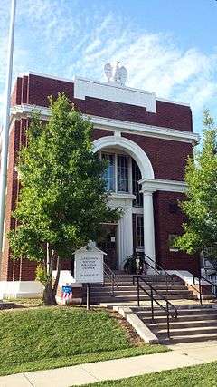
Clarendon, Arkansas
| Clarendon, Arkansas | |
|---|---|
| City | |
|
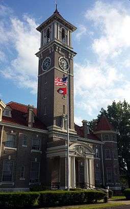
Monroe County Courthouse in downtown Clarendon | |
| Coordinates: 34°41′39″N 91°18′30″W / 34.69417°N 91.30833°WCoordinates: 34°41′39″N 91°18′30″W / 34.69417°N 91.30833°W | |
| Country | United States |
| State | Arkansas |
| County | Monroe |
| Area | |
| • Total | 1.9 sq mi (5 km2) |
| • Land | 1.8 sq mi (4.7 km2) |
| • Water | 0.1 sq mi (0.3 km2) |
| Elevation | 174 ft (53 m) |
| Population (2000) | |
| • Total | 1,965 |
| • Density | 1,031.6/sq mi (392/km2) |
| Time zone | Central (CST) (UTC-6) |
| • Summer (DST) | CDT (UTC-5) |
| ZIP code | 72029 |
| Area code(s) | 870 |
| FIPS code | 05-13990 |
| GNIS feature ID | 0076618 |
Clarendon is a city in and county seat of Monroe County, Arkansas.[1] Located in the Arkansas Delta, the city's position on the White River at the mouth of the Cache River has defined the community since first incorporating in 1859. Although the river has brought devastation and disaster to the city infrequently throughout history, it has also provided economic opportunities, transportation, recreation and tourism to the city.
Once home to a variety of industries, today Clarendon's economy is largely based on agriculture. Similar to many Delta communities, the city's population has been dwindling since mechanization on the farm reduced the number of agricultural-related jobs in the area. At the 2010 Census, the population was 1,664, the lowest value recorded since 1890.[2]
History
Settlement through Antebellum period
The area around Clarendon was originally populated by various Native American groups. By 1799, French hunters and trappers had built cabins at the mouth of the Cache River. It was the point where The Military Road from Memphis, Tennessee to Little Rock crossed the White River. The Military Road was begun in 1826 and completed in 1828. By that date, a ferry crossing and post office had been established in Clarendon, and the town served as the terminus for a stagecoach line to the west. The Military Road was used as the route for some groups of Native Americans being relocated from eastern states to Oklahoma during the forced relocations commonly known as the Trail of Tears; Chickasaw, Choctaw, Creek, and Cherokee groups are known to have traveled along it. A railroad bridge across the White River was constructed in 1883 by the Texas and St. Louis Railway; the ferry operated until 1931 when it was replaced by a highway bridge.
Civil War and Reconstruction
The city of Clarendon was officially incorporated in 1859. In 1864, the city was burned to the ground by Union forces in retaliation for the sinking of the tinclad Union gunboat USS Queen City by forces under the command of Confederate Brigadier General Joseph O. Shelby. The town's charter was dissolved in 1884, and it was reincorporated in 1898.
Gilded Age through Early 20th Century
In the early 1900s, Clarendon developed a number of industries, including lumber, staves and barrels, oars, and buttons made from the shells of the area's plentiful freshwater mussels. The mussels also provided freshwater pearls, which were bought and sold at the Clarendon Pearl Market. The Moss Brothers Bat Company supplied baseball bats to a number of major league baseball players during this era.
Like most of eastern Arkansas, Clarendon was devastated by the Great Mississippi Flood of 1927. The main levee at Clarendon held until the White River reached a height of 38.5 feet, 8.5 above normal flood stage; the flood eventually crested at 44 feet. While no fatalities were reported, the town was inundated by water up to the second floor of many buildings, and the catastrophic inrush of water when the levee broke caused considerable damage to many buildings. The cleanup of mud and debris took many years.
World War II to Modern Era
The area around Clarendon today is primarily agricultural; tourism related to the area's hunting and fishing resources is the most common non-agricultural economic activity. The reported rediscovery of the ivory-billed woodpecker in 2004-2005 in the Cache River and White River National Wildlife Refuges has brought new attention to the area.
Geography
Clarendon is located at 34°41′39″N 91°18′30″W / 34.69417°N 91.30833°W (34.694035, -91.308411).[3]
According to the United States Census Bureau, the city has a total area of 2.0 square miles (5.2 km2), of which, 1.8 square miles (4.7 km2) of it is land and 0.1 square miles (0.26 km2) of it (6.15%) is water.
Clarendon is located at the mouth of the Cache River, where it flows into the White River.
Climate
According to the Köppen Climate Classification system, Clarendon has a humid subtropical climate, abbreviated "Cfa" on climate maps.[4] The climate in this area is characterized by hot, humid summers and generally mild to cool winters.
| Climate data for Clarendon, Arkansas | |||||||||||||
|---|---|---|---|---|---|---|---|---|---|---|---|---|---|
| Month | Jan | Feb | Mar | Apr | May | Jun | Jul | Aug | Sep | Oct | Nov | Dec | Year |
| Record high °F (°C) | 79 (26) |
85 (29) |
86 (30) |
93 (34) |
95 (35) |
102 (39) |
106 (41) |
104 (40) |
101 (38) |
94 (34) |
85 (29) |
79 (26) |
106 (41) |
| Average high °F (°C) | 49 (9) |
54 (12) |
63 (17) |
72 (22) |
81 (27) |
88 (31) |
91 (33) |
91 (33) |
84 (29) |
74 (23) |
62 (17) |
51 (11) |
71.7 (22) |
| Average low °F (°C) | 30 (−1) |
34 (1) |
42 (6) |
50 (10) |
60 (16) |
68 (20) |
72 (22) |
69 (21) |
60 (16) |
49 (9) |
41 (5) |
33 (1) |
50.7 (10.5) |
| Record low °F (°C) | −4 (−20) |
3 (−16) |
15 (−9) |
28 (−2) |
35 (2) |
48 (9) |
53 (12) |
49 (9) |
36 (2) |
28 (−2) |
16 (−9) |
−2 (−19) |
−4 (−20) |
| Average precipitation inches (mm) | 3.69 (93.7) |
4.40 (111.8) |
4.90 (124.5) |
5.17 (131.3) |
5.35 (135.9) |
3.83 (97.3) |
3.86 (98) |
2.27 (57.7) |
3.30 (83.8) |
4.45 (113) |
4.98 (126.5) |
5.51 (140) |
51.71 (1,313.5) |
| Average snowfall inches (cm) | 0.7 (1.8) |
0.2 (0.5) |
0 (0) |
0 (0) |
0 (0) |
0 (0) |
0 (0) |
0 (0) |
0 (0) |
0 (0) |
0 (0) |
0 (0) |
0.9 (2.3) |
| Average precipitation days (≥ 0.01 in) | 9.0 | 9.2 | 9.9 | 8.7 | 10.4 | 7.8 | 7.3 | 5.8 | 6.0 | 7.5 | 8.9 | 9.0 | 99.5 |
| Average snowy days (≥ 0.1 in) | 0.1 | 0 | 0 | 0 | 0 | 0 | 0 | 0 | 0 | 0 | 0 | 0 | 0.1 |
| Source: The Weather Channel[5] | |||||||||||||
Demographics
| Historical population | |||
|---|---|---|---|
| Census | Pop. | %± | |
| 1880 | 400 | — | |
| 1890 | 1,060 | 165.0% | |
| 1900 | 1,840 | 73.6% | |
| 1910 | 2,037 | 10.7% | |
| 1920 | 2,638 | 29.5% | |
| 1930 | 2,149 | −18.5% | |
| 1940 | 2,551 | 18.7% | |
| 1950 | 2,547 | −0.2% | |
| 1960 | 2,293 | −10.0% | |
| 1970 | 2,563 | 11.8% | |
| 1980 | 2,361 | −7.9% | |
| 1990 | 2,072 | −12.2% | |
| 2000 | 1,960 | −5.4% | |
| 2010 | 1,664 | −15.1% | |
| Est. 2015 | 1,504 | [6] | −9.6% |
2014 Estimate[8] | |||
As of the census[9] of 2000, there were 1,960 people, 814 households, and 520 families residing in the city. The population density was 1,072.9 people per square mile (413.5/km²). There were 925 housing units at an average density of 506.3 per square mile (195.2/km²). The racial makeup of the city was 68.47% White, 30.20% Black or African American, 0.46% Native American, 0.05% Asian, and 0.82% from two or more races. 2.35% of the population were Hispanic or Latino of any race.
There were 814 households out of which 26.9% had children under the age of 18 living with them, 43.5% were married couples living together, 16.2% had a female householder with no husband present, and 36.1% were non-families. 33.0% of all households were made up of individuals and 16.7% had someone living alone who was 65 years of age or older. The average household size was 2.38 and the average family size was 3.02.
In the city the population was spread out with 26.3% under the age of 18, 8.1% from 18 to 24, 24.1% from 25 to 44, 25.5% from 45 to 64, and 16.1% who were 65 years of age or older. The median age was 38 years. For every 100 females there were 91.8 males. For every 100 females age 18 and over, there were 86.0 males.
The median income for a household in the city was $22,927, and the median income for a family was $30,250. Males had a median income of $25,972 versus $18,125 for females. The per capita income for the city was $11,902. About 20.8% of families and 28.9% of the population were below the poverty line, including 44.4% of those under age 18 and 26.5% of those age 65 or over.
Economy
The economy of Clarendon is largely defined by the agricultural sector. The city and Clarendon School District are also key employers in the city.
Arts and Culture
Education

Public education for elementary and secondary school students is provided by the Clarendon School District, which includes:
- Clarendon Elementary School, serving prekindergarten through grade 6.
- Clarendon High School, serving grades 7 through 12.
Infrastructure
Healthcare
The Mid-Delta Health Center in Clarendon provides medical and dental services to residents in Clarendon and the surrounding area. A total of 3,318 patients utilized the clinic in 2013 according to the Bureau of Primary Health Care.[10]
Transportation
The major highway through Clarendon is U.S. Highway 79, which gives access to Stuttgart to the south, Marianna to the east and Brinkley (via U.S. Highway 49) to the north. Within the city, U.S. Highway 79B serves the central business district. Highway 302 is a north-south highway that begins at Madison Street in Clarendon and runs north to Highway 17 very near U.S. Highway 70.
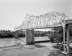
The Clarendon Bridge over the White River has been replaced with a new alignment to the south of Clarendon by the Arkansas State Highway and Transportation Department (AHTD). U.S. Highway 79 was slightly rerouted, with several miles of new bridges constructed over the White River, Cache River, Roc Roe Bayou, and several other waterways. This project will replaced the Clarendon Bridge, a National Register of Historic Places (NRHP) and Historic American Engineering Record (HAER) listed structure built in 1931.[11]
Utilities
Wastewater is collected and conveyed to the Clarendon Wastewater Treatment Plant (WWTP) south of town. The facility uses a lagoon system, filters, and chlorination to produce treated effluent in accordance with the city's NPDES permit administrated by the Arkansas Department of Environmental Quality (ADEQ).[12]
References
- ↑ "Find a County". National Association of Counties. Archived from the original on 2011-05-31. Retrieved 2011-06-07.
- ↑ Mayo, W.R. (January 14, 2014). "Clarendon (Monroe County)". Encyclopedia of Arkansas History and Culture. Butler Center for Arkansas Studies at the Central Arkansas Library System. Retrieved December 21, 2014.
- ↑ "US Gazetteer files: 2010, 2000, and 1990". United States Census Bureau. 2011-02-12. Retrieved 2011-04-23.
- ↑ Climate Summary for Clarendon, Arkansas
- ↑ "Monthly Averages for Clarendon, AR (72029)" (Table). The Weather Channel. Retrieved July 20, 2014.
- ↑ "Annual Estimates of the Resident Population for Incorporated Places: April 1, 2010 to July 1, 2015". Retrieved July 2, 2016.
- ↑ "Census of Population and Housing". Census.gov. Archived from the original on May 11, 2015. Retrieved June 4, 2015.
- ↑ "Annual Estimates of the Resident Population for Incorporated Places: April 1, 2010 to July 1, 2014". Retrieved June 4, 2015.
- ↑ "American FactFinder". United States Census Bureau. Archived from the original on 2013-09-11. Retrieved 2008-01-31.
- ↑ "Mid-Delta Health Systems, Inc.". Health Center Profile. Department of Health and Human Services. 2013. Retrieved December 21, 2014.
- ↑ Smith, Corinne (1988). "Clarendon Bridge" (PDF). AHTD. Retrieved December 21, 2014.
- ↑ "NPDES Permit AR0021644" (PDF). ADEQ. Retrieved December 21, 2014.
External links
| Wikimedia Commons has media related to Clarendon, Arkansas. |
Municipalities and communities of Monroe County, Arkansas, United States | ||
|---|---|---|
| Cities | 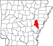 | |
| Towns | ||
| Unincorporated communities | ||
| Footnotes | ‡This populated place also has portions in an adjacent county or counties | |