Iloilo City Proper
City Proper District
La Punta |
|---|
|

Eusebio Villanueva Building, one of the newly restored heritage buildings that line up the historic street of Calle Real |
| Country |
Philippines |
|---|
| Region |
Western Visayas (Region VI) |
|---|
| Province |
Iloilo |
|---|
| City |
Iloilo City |
|---|
| Established (city) |
1890 |
|---|
| Incorporated (together with other districts as Iloilo City) |
July 16, 1937 |
|---|
| Government |
|---|
| • Mayor |
Jed Patrick Mabilog (Liberal) (Mayor of Iloilo City) |
|---|
| Area |
|---|
| • Total |
3.75 km2 (1.45 sq mi) |
|---|
| Time zone |
PST (UTC+8) |
|---|
| ZIP code |
5000 |
|---|
| Area code(s) |
33 |
|---|
| Gentilic |
Ilonggo |
|---|
| Patron Saint |
Santo Niño |
|---|
| Feast Day |
Fourth Sunday of January (coincides with Dinagyang Festival) |
|---|

Barangays by district
| Arevalo |
| No. |
Barangay |
Population[1] |
Area |
| 1. |
Bonifacio |
1,903 |
|
| 2. |
Calaparan |
7,986 |
|
| 3. |
Dulonan |
4,673 |
|
| 4. |
Mohon |
1,373 |
|
| 5. |
Quezon |
2,149 |
|
| 6. |
San Jose |
2,108 |
|
| 7. |
Santa Cruz |
3,050 |
|
| 8. |
Santa Filomena |
2,712 |
|
| 9. |
Santo Domingo |
1,980 |
|
| 10. |
Santo Niño Norte |
3,454 |
|
| 11. |
Santo Niño Sur |
7,248 |
|
| 12. |
So-oc |
7,869 |
|
| 13. |
Yulo Drive |
3,271 |
|
| Iloilo City Proper |
| No. |
Barangay |
Population[1] |
Area |
| 1. |
Arsenal Aduana |
300 |
|
| 2. |
Baybay Tanza |
2,357 |
|
| 3. |
Bonifacio Tanza |
2,799 |
|
| 4. |
Concepcion-Montes |
3,610 |
|
| 5. |
Danao |
450 |
|
| 6. |
Delgado-Jalandoni-Bagumbayan |
275 |
|
| 7. |
Edganzon |
462 |
|
| 8. |
Flores |
583 |
|
| 9. |
General Hughes-Montes |
2,019 |
|
| 10. |
Gloria |
251 |
|
| 11. |
Hipodromo |
771 |
|
| 12. |
Inday |
414 |
|
| 13. |
Jalandoni-Wilson |
898 |
|
| 14. |
Kahirupan |
465 |
|
| 15. |
Kauswagan |
470 |
|
| 16. |
Legaspi dela Rama |
1,067 |
|
| 17. |
Liberation |
633 |
|
| 18. |
Mabolo-Delgado |
950 |
|
| 19. |
Magsaysay |
580 |
|
| 20. |
Malipayon-Delgado |
493 |
|
| 21. |
Maria Clara |
467 |
|
| 22. |
Monica Blumentritt |
1,637 |
|
| 23. |
Muelle Loney-Montes |
1,210 |
|
| 24. |
Nonoy |
530 |
|
| 25. |
Ortiz |
1,440 |
|
| 26. |
Osmeña |
132 |
|
| 27. |
President Roxas |
253 |
|
| 28. |
Rima-Rizal |
855 |
|
| 29. |
Rizal Estanzuela |
3,319 |
|
| 30. |
Rizal Ibarra |
728 |
|
| 31. |
Rizal Palapala I |
2,379 |
|
| 32. |
Rizal Palapala II |
2,349 |
|
| 33. |
Roxas Village |
93 |
|
| 34. |
Sampaguita |
615 |
|
| 35. |
San Agustin |
888 |
|
| 36. |
San Felix |
1,230 |
|
| 37. |
San Jose |
377 |
|
| 38. |
Santo Rosario-Duran |
1,908 |
|
| 39. |
Tanza-Esperanza |
2,277 |
|
| 40. |
Timawa Tanza I |
700 |
|
| 41. |
Timawa Tanza II |
2,005 |
|
| 42. |
Veterans Village |
5,459 |
|
| 43. |
Villa Anita |
1,560 |
|
| 44. |
Yulo-Arroyo |
366 |
|
| 45. |
Zamora-Melliza |
2,511 |
|
| Jaro |
| No. |
Barangay |
Population[1] |
Area |
| 1. |
Arguelles |
901 |
|
| 2. |
Balabago |
8,596 |
|
| 3. |
Balantang |
3,136 |
|
| 4. |
Benedicto |
2,827 |
|
| 5. |
Bito-on |
5,679 |
|
| 6. |
Buhang |
2,744 |
|
| 7. |
Buntatala |
3,676 |
|
| 8. |
Calubihan |
1,353 |
|
| 9. |
Camalig |
2,185 |
|
| 10. |
Cuartero |
2,956 |
|
| 11. |
Cubay |
6,715 |
|
| 12. |
Democracia |
1,660 |
|
| 13. |
Desamparados |
1,022 |
|
| 14. |
Dungon A |
1,510 |
|
| 15. |
Dungon B |
3,086 |
|
| 16. |
El 98 Castilla (Claudio Lopez) |
210 |
|
| 17. |
Fajardo |
990 |
|
| 18. |
Javellana |
391 |
|
| 19. |
Lanit |
2,658 |
|
| 20. |
Libertad, Santa Isabel |
636 |
|
| 21. |
Lopez Jaena |
740 |
|
| 22. |
Luna |
420 |
|
| 23. |
M.V. Hechanova |
4,181 |
|
| 24. |
Marcelo H. del Pilar |
3,895 |
|
| 25. |
Maria Cristina |
1,005 |
|
| 26. |
Montinola |
1,155 |
|
| 27. |
Our Lady of Fatima |
1,305 |
|
| 28. |
Our Lady of Lourdes |
2,180 |
|
| 29. |
Quintin Salas |
4,296 |
|
| 30. |
Sambag |
5,830 |
|
| 31. |
San Isidro |
6,268 |
|
| 32. |
San Jose |
375 |
|
| 33. |
San Pedro |
1,100 |
|
| 34. |
San Roque |
1,579 |
|
| 35. |
San Vicente |
1,332 |
|
| 36. |
Seminario (Burgos Jalandoni) |
233 |
|
| 37. |
Simon Ledesma |
2,120 |
|
| 38. |
Tabuc Suba |
8,450 |
|
| 39. |
Tacas |
5,204 |
|
| 40. |
Tagbac |
4,450 |
|
| 41. |
Taytay Zone II |
1,100 |
|
| 42. |
Ungka |
2,890 |
|
| La Paz |
| No. |
Barangay |
Population[1] |
Area |
| 1. |
Aguinaldo |
1,229 |
|
| 2. |
Baldoza |
6,214 |
|
| 3. |
Bantud |
524 |
|
| 4. |
Banuyao |
1,230 |
|
| 5. |
Burgos-Mabini-Plaza |
1,920 |
|
| 6. |
Caingin |
3,848 |
|
| 7. |
Divinagracia |
1,380 |
|
| 8. |
Gustilo |
2,670 |
|
| 9. |
Hinactacan |
510 |
|
| 10. |
Ingore |
3,256 |
|
| 11. |
Jereos |
4,139 |
|
| 12. |
Laguda |
145 |
|
| 13. |
Lopez Jaena Norte |
2,100 |
|
| 14. |
Lopez Jaena Sur |
1,500 |
|
| 15. |
Luna |
450 |
|
| 16. |
MacArthur |
1,011 |
|
| 17. |
Magdalo |
721 |
|
| 18. |
Magsaysay Village |
1,630 |
|
| 19. |
Nabitasan |
2,196 |
|
| 20. |
Railway |
1,320 |
|
| 21. |
Rizal |
1,519 |
|
| 22. |
San Isidro |
3,650 |
|
| 23. |
San Nicolas |
1,465 |
|
| 24. |
Tabuc Suba |
3,120 |
|
| 25. |
Ticud |
2,562 |
|
| Lapuz |
| No. |
Barangay |
Population[1] |
Area |
| 1. |
Alalasan |
2,001 |
|
| 2. |
Don Esteban |
2,899 |
|
| 3. |
Jalandoni Estate |
2,170 |
|
| 4. |
Lapuz Norte |
2,515 |
|
| 5. |
Lapuz Sur |
1,806 |
|
| 6. |
Libertad |
1,037 |
|
| 7. |
Loboc |
2,616 |
|
| 8. |
Mansaya |
3,620 |
|
| 9. |
Obrero |
6,592 |
|
| 10. |
Progreso |
1,134 |
|
| 11. |
Punong |
1,387 |
|
| 12. |
Sinikway (Bangkerohan) |
3,886 |
|
| Mandurriao |
| No. |
Barangay |
Population[1] |
Area |
| 1. |
Abeto Mirasol Taft South (Quirino Abeto) |
2,277 |
|
| 2. |
Airport (Tabucan Airport) |
3,374 |
|
| 3. |
Bakhaw |
5,829 |
|
| 4. |
Bolilao |
6,481 |
|
| 5. |
Buhang Taft North |
2,723 |
|
| 6. |
Calahunan |
3,356 |
|
| 7. |
Dungon |
2,519 |
|
| 8. |
Guzman-Jesena |
5,250 |
|
| 9. |
Hibao-an Norte |
2,168 |
|
| 10. |
Hibao-an Sur |
2,220 |
|
| 11. |
Navais |
4,020 |
|
| 12. |
Oñate de Leon |
4,106 |
|
| 13. |
Pale Benedicto Rizal |
2,733 |
|
| 14. |
PHHC Block 17 |
1,529 |
|
| 15. |
PHHC Block 22 NHA |
1,407 |
|
| 16. |
San Rafael |
1,260 |
|
| 17. |
Santa Rosa |
775 |
|
| 18. |
Tabucan |
2,352 |
|
| Molo |
| No. |
Barangay |
Population[1] |
Area |
| 1. |
Calumpang |
11,113 |
|
| 2. |
Cochero |
1,088 |
|
| 3. |
Compania |
3,717 |
|
| 4. |
East Baluarte |
1,745 |
|
| 5. |
East Timawa |
1,279 |
|
| 6. |
Habog-Habog Salvacion |
2,117 |
|
| 7. |
Infante |
1,380 |
|
| 8. |
Kasingkasing |
2,601 |
|
| 9. |
Katilingban |
1,142 |
|
| 10. |
Molo Boulevard |
7,600 |
|
| 11. |
North Avanceña |
732 |
|
| 12. |
North Baluarte |
4,136 |
|
| 13. |
North Fundidor |
2,042 |
|
| 14. |
North San Jose |
1,503 |
|
| 15. |
Poblacion Molo |
820 |
|
| 16. |
San Antonio |
2,080 |
|
| 17. |
San Juan |
9,840 |
|
| 18. |
San Pedro |
2,780 |
|
| 19. |
South Baluarte |
1,403 |
|
| 20. |
South Fundidor |
3,190 |
|
| 21. |
South San Jose |
2,301 |
|
| 22. |
Taal |
940 |
|
| 23. |
Tap-oc |
600 |
|
| 24. |
West Habog-Habog |
2,219 |
|
| 25. |
West Timawa |
1,950 |
|
Iloilo City Proper is one of the seven districts also known as the center or heart of Iloilo City. It received its present name from the province's original Irong-Irong reference. Originally founded as La Punta, it was only inhabited in 1602 when Spanish and Chinese residents from Jaro and Molo expanded their territorial area. [2]
History
The town was once invaded by the Dutch in the 17th Century, who were later driven away, and later emerged as a trading port in the 19th century. Its geographical and economic significance eventually evolved when China, Norway and the United Kingdom opened up their consulates to conduct trade and commerce in the town, especially during its foundation as an international port in the 1850s.
Plaza Libertad, the city's historical square, was the site where the Philippine flag was raised for the first time in the island of Panay on December 25, 1898 during the Philippine Revolution when local troops led by Gen. Martin Delgado defeated the Spanish army.
In the 20th century, all economic activities shifted from Jaro and Molo to the town of Iloilo when businesses aggressively flourished here. It was later transformed into a chartered city and absorbed the old towns of Molo, Arevalo, Mandurriao and La Paz as well the city of Jaro.
Main sights
The district is the home to the main government building of the Province of Iloilo, the Iloilo Provicial Capitol and the seat of the City Government, the Iloilo City Hall. Other main agencies of the government is also located at the City Proper. Its main thoroughfares are J.M. Basa St. (Calle Real), Iznart St., Gen. Luna St. and Ledesma St. It has the most service and commercial establishments among all districts.
Gallery
A scene at Iznart St. during a Chinese new year parade.
Construction of the new Iloilo City Hall.
San José de Placer Church fronting Plaza Libertad
Plaza Libertad
References
Iloilo Travel Guide
Coordinates: 10°41′09″N 122°30′42″E / 10.6858°N 122.5117°E / 10.6858; 122.5117

 A scene at Iznart St. during a Chinese new year parade.
 Construction of the new Iloilo City Hall.
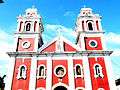 San José de Placer Church fronting Plaza Libertad
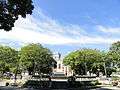 Plaza Libertad