Church of St. George, Sopotnica

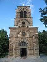
The Church of Saint George, Sopotnica (Serbian: Црква светог Ђорђа, Сопотница) is a Serbian Orthodox church located at the village of Sopotnica in the Municipality of Novo Goražde in eastern Republika Srpska, Bosnia and Herzegovina. The church stands at the left bank of the Drina River, 4 kilometres from the town of Goražde. It was built in 1454 by Stefan Vukčić Kosača, when Goražde was part of a region ruled by him.[1][2] The region would later come to be known as Herzegovina, after Kosača's title Herceg of Saint Sava.[3] Herzegovina was gradually conquered by the Ottoman Empire between 1465 and 1481.[4]
In the second half of the 16th century, during the office of Serbian Patriarch Makarije Sokolović, the church was enlarged on its western side. It was repaired in 1869, when a metal door was installed at its entrance, which was donated by a Serb from Sarajevo.[1] Remains of its old frescoes were then carefully collected and buried beside the church's wall.[5] A bell tower was added at the church's western side in 1894. At the beginning of the Bosnian War, the church was shelled and set on fire in September 1992. It remained roofless until October 1994, when a temporary roof was installed. The church was restored between 2000 and 2002, and in 2008, it was designated as a National Monument of Bosnia and Herzegovina.[1]
In 1519, at the beginning of the Ottoman rule over Herzegovina, one of the earliest printing houses among the Serbs was established at the church. Known as the Goražde printing house,[6][7] it was the first such facility in the territory of present-day Bosnia and Herzegovina.[8] It produced three books: a hieratikon (priest's service book) in 1519, a psalter in 1521, and a small euchologion in 1523.[9]
Notes
References
- Barać, Dragan (2008). "Горажданска штампарија—прва међу штампаријама у Херцеговини и српским земљама 16. века". In Dragan Barać. Горажданска штампарија 1519–1523 [The Goražde Printing House 1519–1523] (in Serbian). Belgrade: National Library of Serbia; East Sarajevo: Philosophical Faculty of the University of East Sarajevo. ISBN 978-86-7035-186-8.
- Benac, Alojz; Lovrenović, Ivan (1980). Bosnia and Herzegovina. Sarajevo: Svjetlost.
- Fine, John Van Antwerp (1994). The Late Medieval Balkans: A Critical Survey from the Late Twelfth Century to the Ottoman Conquest. Ann Arbor, Michigan: University of Michigan Press. ISBN 0-472-08260-4.
- Fotić, Aleksandar (2005). "Belgrade: A Muslim and Non-Muslim Cultural Centre (Sixteenth–Seventeenth Centuries)". In Antonis Anastasopoulos. Provincial elites in the Ottoman Empire. Halcyon Days in Crete. 5. Rethymno: Crete University Press. ISBN 9789605242169.
- Lovrenović, Dubravko (2008). Church of Saint George in Sopotnica. Bosnia and Herzegovina Commission to Preserve National Monuments.
- Ševo, Ljiljana (2004). Manastir Liplje (in Serbian). Lepavina Monastery.
Coordinates: 43°41′01″N 19°00′06″E / 43.683624°N 19.001799°E