Choteau, Montana
| Choteau, Montana | |
|---|---|
| City | |
|
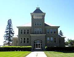
Aerial view of Choteau | |
 Location of Choteau, Montana | |
| Coordinates: 47°49′N 112°11′W / 47.817°N 112.183°WCoordinates: 47°49′N 112°11′W / 47.817°N 112.183°W | |
| Country | United States |
| State | Montana |
| County | Teton |
| Area[1] | |
| • Total | 1.83 sq mi (4.74 km2) |
| • Land | 1.83 sq mi (4.74 km2) |
| • Water | 0 sq mi (0 km2) |
| Elevation | 3,819 ft (1,164 m) |
| Population (2010)[2] | |
| • Total | 1,684 |
| • Estimate (2015)[3] | 1,696 |
| • Density | 920.2/sq mi (355.3/km2) |
| Time zone | Mountain (MST) (UTC-7) |
| • Summer (DST) | MDT (UTC-6) |
| ZIP code | 59422 |
| Area code(s) | 406 |
| FIPS code | 30-14650 |
| GNIS feature ID | 0800592 |

Choteau is a city in and the county seat of Teton County, Montana, United States.[4] It lies along U.S. Routes 89 and 287 (the latter terminating at the former in this city) about 20 miles (32 km) east of the Rocky Mountains, near Flathead National Forest, the Rocky Mountain Division of Lewis and Clark National Forest, and Glacier National Park. The population was 1,684 at the 2010 census. The Montana town is named for French fur-trapper and explorer Pierre Chouteau, Jr., who is also the namesake of Chouteau County, Montana (county seat: Fort Benton).[5]
Geography
According to the United States Census Bureau, the city has a total area of 1.83 square miles (4.74 km2), all of it land.[1] The Teton River runs nearby, although for some distance upstream of Choteau, it is dry during much of the year.
Demographics
| Historical population | |||
|---|---|---|---|
| Census | Pop. | %± | |
| 1920 | 1,043 | — | |
| 1930 | 926 | −11.2% | |
| 1940 | 1,181 | 27.5% | |
| 1950 | 1,618 | 37.0% | |
| 1960 | 1,966 | 21.5% | |
| 1970 | 1,586 | −19.3% | |
| 1980 | 1,798 | 13.4% | |
| 1990 | 1,741 | −3.2% | |
| 2000 | 1,781 | 2.3% | |
| 2010 | 1,684 | −5.4% | |
| Est. 2015 | 1,696 | [6] | 0.7% |
| U.S. Decennial Census[7][8] 2015 Estimate[3] | |||
2010 census
As of the census[2] of 2010, there were 1,684 people, 791 households, and 441 families residing in the city. The population density was 920.2 inhabitants per square mile (355.3/km2). There were 888 housing units at an average density of 485.2 per square mile (187.3/km2). The racial makeup of the city was 95.0% White, 2.1% Native American, 0.2% Asian, 0.1% Pacific Islander, 0.3% from other races, and 2.3% from two or more races. Hispanic or Latino of any race were 1.7% of the population.
There were 791 households of which 21.9% had children under the age of 18 living with them, 45.8% were married couples living together, 6.8% had a female householder with no husband present, 3.2% had a male householder with no wife present, and 44.2% were non-families. 39.6% of all households were made up of individuals and 20% had someone living alone who was 65 years of age or older. The average household size was 2.04 and the average family size was 2.75.
The median age in the city was 49.1 years. 19.5% of residents were under the age of 18; 5.1% were between the ages of 18 and 24; 19.8% were from 25 to 44; 29.8% were from 45 to 64; and 25.8% were 65 years of age or older. The gender makeup of the city was 46.4% male and 53.6% female.
2000 census
As of the census[9] of 2000, there were 1,781 people, 807 households, and 464 families residing in the city. The population density was 994.3 people per square mile (383.9/km2). There were 897 housing units at an average density of 500.8 per square mile (193.4/km2). The racial makeup of the city was 93.94% White, 0.06% African American, 2.92% Native American, 0.11% Asian, 0.22% from other races, and 2.75% from two or more races. Hispanic or Latino of any race were 1.18% of the population.
There were 807 households out of which 24.9% had children under the age of 18 living with them, 46.8% were married couples living together, 8.6% had a female householder with no husband present, and 42.4% were non-families. 39.2% of all households were made up of individuals and 21.9% had someone living alone who was 65 years of age or older. The average household size was 2.13 and the average family size was 2.82.
In the city the population was spread out with 22.7% under the age of 18, 4.4% from 18 to 24, 21.4% from 25 to 44, 25.8% from 45 to 64, and 25.7% who were 65 years of age or older. The median age was 46 years. For every 100 females there ware 86.3 males. For every 100 females age 18 and over, there were 80.9 males.
The median income for a household in the city was $25,708, and the median income for a family was $35,655. Males had a median income of $22,429 versus $17,098 for females. The per capita income for the city was $14,999. About 12.7% of families and 17.6% of the population were below the poverty line, including 30.2% of those under the age of 18 and 12.5% of those 65 and older.
Government
Choteau's mayor is John W. "Jack" Conatser.[10]
In the news
Choteau has made national news in the U.S. because it is the town nearest to a 2,700-acre (11 km2) ranch that David Letterman purchased in 1999 as a vacation home. Letterman has talked about the ranch on his late-night show and showed photos of a black bear invading the place in September 2003.
On his first show after the attacks of September 11, 2001, Letterman gave an impassioned monologue about New York City in the aftermath. He concluded the now-famous 7-minute speech by mentioning Choteau's rally to raise money for victims of the attacks, despite the long drought there.[11]
On March 19, 2009, Letterman married his girlfriend of 23 years at the Teton County Courthouse in Choteau.[12]
In 2008, school authorities in Choteau made national news headlines by canceling a speaking engagement by Nobel laureate climate researcher Steve Running, who was scheduled to speak to local high school students.[13]
Climate
Choteau experiences a semi-arid climate (Köppen BSk) with cold, dry winters and hot, wetter summers.
| Climate data for Choteau, Montana | |||||||||||||
|---|---|---|---|---|---|---|---|---|---|---|---|---|---|
| Month | Jan | Feb | Mar | Apr | May | Jun | Jul | Aug | Sep | Oct | Nov | Dec | Year |
| Record high °F (°C) | 75 (24) |
72 (22) |
82 (28) |
86 (30) |
92 (33) |
97 (36) |
105 (41) |
106 (41) |
96 (36) |
90 (32) |
80 (27) |
78 (26) |
106 (41) |
| Average high °F (°C) | 33.7 (0.9) |
39.2 (4) |
46.3 (7.9) |
56.0 (13.3) |
65.3 (18.5) |
73.7 (23.2) |
81.0 (27.2) |
80.9 (27.2) |
70.3 (21.3) |
59.4 (15.2) |
42.5 (5.8) |
35.7 (2.1) |
57 (13.88) |
| Daily mean °F (°C) | 23.5 (−4.7) |
28.3 (−2.1) |
35.1 (1.7) |
43.9 (6.6) |
52.8 (11.6) |
60.8 (16) |
66.4 (19.1) |
66.0 (18.9) |
56.5 (13.6) |
47.1 (8.4) |
33.1 (0.6) |
25.9 (−3.4) |
44.95 (7.19) |
| Average low °F (°C) | 13.2 (−10.4) |
17.4 (−8.1) |
23.8 (−4.6) |
31.7 (−0.2) |
40.2 (4.6) |
47.8 (8.8) |
51.7 (10.9) |
51.0 (10.6) |
42.7 (5.9) |
34.7 (1.5) |
23.6 (−4.7) |
16.1 (−8.8) |
32.83 (0.46) |
| Record low °F (°C) | −44 (−42) |
−50 (−46) |
−36 (−38) |
−16 (−27) |
8 (−13) |
28 (−2) |
28 (−2) |
29 (−2) |
−5 (−21) |
−15 (−26) |
−30 (−34) |
−43 (−42) |
−50 (−46) |
| Average precipitation inches (mm) | 0.25 (6.4) |
0.19 (4.8) |
0.34 (8.6) |
0.72 (18.3) |
2.00 (50.8) |
2.15 (54.6) |
1.31 (33.3) |
1.38 (35.1) |
0.99 (25.1) |
0.52 (13.2) |
0.25 (6.4) |
0.22 (5.6) |
10.32 (262.2) |
| Source #1: NOAA (normals, 1971–2000) [14] | |||||||||||||
| Source #2: The Weather Channel (Records) [15] | |||||||||||||
Notable residents
- John Edward Erickson, Governor of Montana, was born in Stoughton.[16]
- J. Frank Glendon, early film actor
- A.B. Guthrie Jr., American novelist
- David Letterman, late night talk show host
- Jay Neitz, renowned vision scientist
- J. K. Ralston, born here, western painter
- Flint Rasmussen, rodeo clown
- Jim Waltermire, Montana Secretary of State, was born in Choteau.
Dinosaurs
Choteau is near one of the most important paleontology sites in the world, Egg Mountain.[17] The Old Trail Museum in Choteau is home to the Maiasaura type fossil, which is the Montana State Fossil. The 3-D display can be viewed during the summer operating season. Also showcased is the Egg Mountain find along with a commentary on the significance to the paleontology world.[18] [19]
Education
Choteau Public Schools serves all grades of children in the community. Choteau High School received a 2009 Best High School Bronze Award recognition from U.S. News & World Report for its excellence in education.[20]
The elementary school has 214 students in grades K-8 while the high school has 113 students in grades 9-12.[21]
References
- 1 2 "US Gazetteer files 2010". United States Census Bureau. Archived from the original on 2012-01-24. Retrieved 2012-12-18.
- 1 2 "American FactFinder". United States Census Bureau. Retrieved 2012-12-18.
- 1 2 "Population Estimates". United States Census Bureau. Retrieved July 20, 2016.
- ↑ "Find a County". National Association of Counties. Archived from the original on May 10, 2015. Retrieved June 7, 2011.
- ↑ "Origins of Names on Milwaukee". Roundup Record-Tribune & Winnett Times. August 22, 1940. p. 6. Retrieved April 27, 2015.
- ↑ "Annual Estimates of the Resident Population for Incorporated Places: April 1, 2010 to July 1, 2015". Retrieved July 2, 2016.
- ↑ "Census of Population and Housing". Census.gov. Archived from the original on May 11, 2015. Retrieved June 4, 2015.
- ↑ "Census & Economic Information Center". Retrieved July 3, 2015.
- ↑ "American FactFinder". United States Census Bureau. Archived from the original on 2013-09-11. Retrieved 2008-01-31.
- ↑ Retrieved 2014-07-02
- ↑ Ted (September 11, 2003). "Live from New York". Crooked Timber.
- ↑ "David Letterman marries longtime girlfriend Regina Lasko". Chicago Tribune. March 24, 2009.
- ↑ Robbins, Jim (January 17, 2008). "Climate Talk's Cancellation Splits a Town". The New York Times.
- ↑ "Climatography of the United States NO.81" (PDF). National Oceanic and Atmospheric Administration. Retrieved January 15, 2011.
- ↑ "Monthly Averages for Choteau, MT". The Weather Channel. Retrieved January 15, 2011.
- ↑ "Montana Governor John Edward Erickson". National Governors Association. Retrieved October 10, 2012.
- ↑ "About.com:Dinosaurs". Retrieved 17 January 2010.
- ↑ "The Montana Dinosaur Trail". Retrieved 17 January 2010.
- ↑ "The Old Trail Museum - Maiasaura Exhibit". Retrieved 17 January 2010.
- ↑ http://www.usnews.com/listings/high-schools/montana/choteau_high_school
- ↑ http://www.choteauacantha.com/
External links
Municipalities and communities of Teton County, Montana, United States | ||
|---|---|---|
| City | 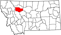 | |
| Towns | ||
| CDPs | ||
| Unincorporated communities | ||