Chisana, Alaska
| Chisana Tsetsaan’ Na’ | |
|---|---|
| CDP | |
|
Chisana's post office | |
 Chisana Location within the state of Alaska | |
| Coordinates: 62°4′16″N 141°59′36″W / 62.07111°N 141.99333°WCoordinates: 62°4′16″N 141°59′36″W / 62.07111°N 141.99333°W | |
| Country | United States |
| State | Alaska |
| Census Area | Valdez-Cordova |
| Government | |
| • State senator | Click Bishop (R) |
| • State rep. | Dave Talerico (R) |
| Area | |
| • Total | 86.7 sq mi (224.7 km2) |
| • Land | 86.7 sq mi (224.4 km2) |
| • Water | 0.1 sq mi (0.2 km2) |
| Elevation | 3,369 ft (1,027 m) |
| Population (2010) | |
| • Total | 0 |
| Time zone | Alaska (AKST) (UTC-9) |
| • Summer (DST) | AKDT (UTC-8) |
| Area code(s) | 907 |
| FIPS code | 02-13890 |
| GNIS feature ID | 1400321 |
|
Chisana Historic Mining Landscape | |
| Location | Extending west ¼ mile from the southeastern end of Chisana Airstrip and parallel to Johnson Creek; expanded to vicinity of Chisana and Gold Hill |
| Area | Originally 30 acres (0.047 sq mi; 0.12 km2); expanded to 27,216 acres (42.525 sq mi; 110.14 km2) |
| Built | 1913 |
| Architect | Multiple |
| Architectural style | Log Cabin |
| NRHP Reference # |
85002999[1] (original) 98000436 (increase) |
| Significant dates | |
| Added to NRHP | November 29, 1985 |
| Boundary increase | May 14, 1998 |
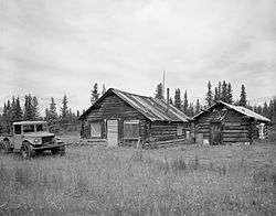
Chisana (also Shushanna) (Tsetsaan’ Na’ in Ahtna) is a ghost town abandoned and a census-designated place (CDP) in the Valdez-Cordova Census Area in the U.S. state of Alaska. As of the 2010 Census,[2] the population of the CDP was 0. The English name Chisana derives from the Ahtna Athabascan name Tsetsaan' Na', meaning literally 'copper river' (not to be confused with the river known in English as the Copper River).
In 1985, the community was listed on the National Register of Historic Places as a historic district, the Chisana Historic District. This district was substantially enlarged (to encompass more than 27,000 acres (42 sq mi; 110 km2)) and renamed the "Chisana Historic Mining Landscape" in 1998.[1]
Geography
Chisana is located at 62°4′16″N 141°59′36″W / 62.07111°N 141.99333°W (62.070992, -141.993271).[3]
According to the United States Census Bureau, the CDP has a total area of 86.7 square miles (225 km2), of which 86.7 square miles (225 km2) of it is land and 0.1 square miles (0.26 km2) of it is water. The total area is 0.10% water. Chisana is the highest community in Alaska at 3,318 feet (1,011.3 meters) above sea level.[4]
See also
- National Register of Historic Places listings in Valdez-Cordova Census Area, Alaska
- National Register of Historic Places listings in Southeast Fairbanks Census Area, Alaska
References
- 1 2 National Park Service (2009-03-13). "National Register Information System". National Register of Historic Places. National Park Service.
- ↑ "American FactFinder". United States Census Bureau. Archived from the original on 2013-09-11. Retrieved 2008-01-31.
- ↑ "US Gazetteer files: 2010, 2000, and 1990". United States Census Bureau. 2011-02-12. Retrieved 2011-04-23.
- ↑ Alaska Cities by Highest Elevation. Retrieved 2011-06-24.
External links
- Chisana Airport
- Alaska Division of Community Advocacy - Community Information Summary
- Historic American Landscapes Survey (HALS) No. AK-6, "Scenic views, Chisana, Valdez-Cordova Census Area, AK", 3 color transparencies, 1 photo caption page
Municipalities and communities of Valdez–Cordova Census Area, Alaska, United States | ||
|---|---|---|
| Cities | 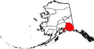 | |
| CDPs | ||
| Unincorporated communities | ||
| Ghost towns | ||