Cherokee, Alabama
| Cherokee, Alabama | |
|---|---|
| Town | |
 Location in Colbert County and the state of Alabama | |
| Coordinates: 34°45′30″N 87°58′7″W / 34.75833°N 87.96861°W | |
| Country | United States |
| State | Alabama |
| County | Colbert |
| Government | |
| • Type | Mayor–council government |
| • Mayor | Terry Cosby |
| Area | |
| • Total | 2.2 sq mi (5.7 km2) |
| • Land | 2.2 sq mi (5.7 km2) |
| • Water | 0 sq mi (0 km2) |
| Elevation | 540 ft (162 m) |
| Population (2010) | |
| • Total | 1,048 |
| • Density | 473/sq mi (182.6/km2) |
| Time zone | Central (UTC-6) |
| • Summer (DST) | Central (UTC-5) |
| ZIP code | 35616 |
| Area code(s) | 256 |
| FIPS code | 01-14152 |
| GNIS feature ID | 0115997 |
Cherokee is a town in west Colbert County, Alabama, United States. It is part of the Florence–Muscle Shoals metropolitan area, known as "The Shoals". As of the 2010 census, the population of the town was 1,048.[1]
History


Cherokee was incorporated December 7, 1871.[2]
Geography
According to the U.S. Census Bureau, Cherokee has a total area of 2.2 square miles (5.7 km2), all land.[1]
Climate
| Average Low | Average High | |
|---|---|---|
| January | 26 °F | 47 °F |
| April | 44 °F | 71 °F |
| July | 66 °F | 89 °F |
| October | 44 °F | 72 °F |
- Annual Precipitation 60.6 inches
Demographics
| Historical population | |||
|---|---|---|---|
| Census | Pop. | %± | |
| 1880 | 282 | — | |
| 1900 | 261 | — | |
| 1910 | 269 | 3.1% | |
| 1920 | 524 | 94.8% | |
| 1930 | 659 | 25.8% | |
| 1940 | 786 | 19.3% | |
| 1950 | 748 | −4.8% | |
| 1960 | 1,349 | 80.3% | |
| 1970 | 1,484 | 10.0% | |
| 1980 | 1,589 | 7.1% | |
| 1990 | 1,479 | −6.9% | |
| 2000 | 1,237 | −16.4% | |
| 2010 | 1,048 | −15.3% | |
| Est. 2015 | 1,014 | [4] | −3.2% |
| U.S. Decennial Census[5] 2013 Estimate[6] | |||

2000 census
As of the census[7] of 2000, there were 1,237 people, 510 households, and 370 families residing in the town. The population density was 552.5 people per square mile (213.2/km2). There were 557 housing units at an average density of 248.8 per square mile (96.0/km2). The racial makeup of the town was 78.33% White, 20.21% Black or African American, 0.32% Native American, and 1.13% from two or more races. 0.49% of the population were Hispanic or Latino of any race.
There were 510 households out of which 30.0% had children under the age of 18 living with them, 51.8% were married couples living together, 16.5% had a female householder with no husband present, and 27.3% were non-families. 25.3% of all households were made up of individuals and 13.5% had someone living alone who was 65 years of age or older. The average household size was 2.43 and the average family size was 2.88.
In the town the population was spread out with 24.7% under the age of 18, 7.0% from 18 to 24, 25.9% from 25 to 44, 24.6% from 45 to 64, and 17.9% who were 65 years of age or older. The median age was 38 years. For every 100 females there were 91.8 males. For every 100 females age 18 and over, there were 82.2 males.
The median income for a household in the town was $24,597, and the median income for a family was $28,839. Males had a median income of $26,667 versus $20,096 for females. The per capita income for the town was $12,431. About 18.6% of families and 22.6% of the population were below the poverty line, including 31.7% of those under age 18 and 15.7% of those age 65 or over.
2010 census
As of the census[8] of 2010, there were 1,048 people, 452 households, and 315 families residing in the town. The population density was 473 people per square mile (182.6/km2). There were 529 housing units at an average density of 240.5 per square mile (92.8/km2). The racial makeup of the town was 77.6% White, 18.3% Black or African American, 0.5% Native American, and 2.3% from two or more races. 1.7% of the population were Hispanic or Latino of any race.
There were 452 households out of which 25.4% had children under the age of 18 living with them, 47.6% were married couples living together, 16.8% had a female householder with no husband present, and 30.3% were non-families. 26.8% of all households were made up of individuals and 14.6% had someone living alone who was 65 years of age or older. The average household size was 2.32 and the average family size was 2.78.
In the town the population was spread out with 21.3% under the age of 18, 7.2% from 18 to 24, 22.8% from 25 to 44, 27.1% from 45 to 64, and 21.7% who were 65 years of age or older. The median age was 44.1 years. For every 100 females there were 95.5 males. For every 100 females age 18 and over, there were 102.0 males.
The median income for a household in the town was $36,875, and the median income for a family was $41,250. Males had a median income of $37,581 versus $23,421 for females. The per capita income for the town was $18,038. About 20.5% of families and 20.9% of the population were below the poverty line, including 36.1% of those under age 18 and 12.2% of those age 65 or over.
The current mayor of Cherokee is Terry Cosby. The Chief of Police is Jason Williamson.
Education
Schools in Cherokee are part of the Colbert County School System and serve rural western Colbert County. Cherokee Elementary School and Cherokee High School are located on the northern side of town along North Pike. The land for this complex, including the football field, was donated by the Harris family of Cherokee.
The population in western Colbert County has declined in recent years. Cherokee Middle School closed after the 2006 / 2007 year and was consolidated into Cherokee Elementary and Cherokee High Schools. The site was once home to one of the original Rosenwald Schools. The former middle school now serves as the town hall while it is still owned by the Colbert County Board of Education.[9]
Transportation
Major highways
U.S. Highway 72
US Highway 72 is the major corridor through Cherokee. This important highway followed the railroad and was once known as the Memphis Pike. U.S. Highway 72 is still part of the Lee Highway.
Natchez Trace Parkway
The Natchez Trace Parkway passes north and west of Cherokee and is part of the National Park Service. This highway provides a vital source of tourism for the area.
Rail
The Memphis and Charleston Railroad was vital to the founding of present-day Cherokee. Once a vital passenger carrier for the area, the railroad is an important artery for the Norfolk Southern Railway system, connecting Chattanooga and Memphis. The railroad has a spur to Cherokee Nitrogen to transport ammonia and ammonium nitrate manufactured by the facility.
River
The Tennessee River was a critical transportation corridor for the South during the American Civil War. The river provides recreation, continues to transport goods, and is an important factor in industrial activity in the area.
Air
Northwest Alabama Regional Airport is located 23 miles (37 km) east of Cherokee. It is served by Delta Connection - Mesaba Airlines, providing public transportation to Atlanta.
Economy
Barton Riverfront Industrial Park
The Barton Riverfront Industrial Park is located in the Barton community east of Cherokee near the Tennessee River. The park was constructed to attract industry to western Colbert County and has become an important economical revitalization to the area. The first company to locate in the park was SCA Tissue North America which started operation in 2004.[10]
In July, 2007 National Steel Car announced a decision to locate a new manufacturing facility in the industrial park, the largest new employer in Colbert County in the prior 40 years.[11] The facility has become an independent entity of its former parent and is now named National Alabama Corporation.[12] Retirement Systems of Alabama is the primary shareholder.[13]
Major employers
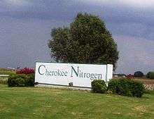
Cherokee Nitrogen
Cherokee Nitrogen, owned by LSB Industries, is located on the north side of town. It was built in 1962 by Armour Agri-Chemicals and has been owned by USS Agri-Chemicals (a division of United States Steel) and LaRoche Industries before being bought by LSB Industries. Cherokee Nitrogen provides nitrogen products, ammonia, and ammonia nitrate. Located adjacent to the facility is Nelson Brothers who uses the ammonia nitrate in the production of dynamite and Linde who sells Carbon Dioxide produced as a byproduct of the process at Cherokee Nitrogen.
On the night of November 13, 2012, Cherokee Nitrogen was the scene of a devastating explosion heard 45 miles (72 km) away that left at least one employee injured. It was felt all across the "Shoals".
SCA Tissue North America
SCA Tissue North America, a division of Svenska Cellulosa Aktiebolaget, was the first tenant of the Barton Riverfront Industrial Park located east of town in the Barton community. As of 2010 it has undergone several expansions and is Cherokee's largest employer.[14]
Vulcan Materials
Vulcan Materials' Cherokee Facility has been located on the east edge of town for many years. Crushed limestone from this quarry is used throughout Alabama and Mississippi.
UCM Magnesia
UCM Magnesia is located in the Barton area. Originally Muscle Shoals ElectroChemical Corp, it was also owned by Glasrock and later Muscle Shoals Minerals. This facility is an important supplier of high quality magnesia powder.
National Alabama
National Alabama was designed to provide steel railcars and was expected to be the largest employer in the area. As of 2010 the depressed economy has delayed full production at the facility and the company is looking for alternative products to produce.[13]
Local attractions
Natchez Trace Parkway
The Natchez Trace Parkway is one of the most significant historical attractions in the area. The section of the Natchez Trace near Cherokee includes the Colbert Ferry site, the home of George Colbert and of Levi Colbert. The Colbert family were leaders of the Chickasaw Nation that resided in this area before they were forcibly relocated in the 19th century.
Key Underwood Coon Dog Memorial Graveyard
Key Underwood Coon Dog Memorial Graveyard is one of the world's most unusual cemeteries; it is dedicated to the burial of coon dogs. Each Labor Day a large celebration is held at the graveyard and is attended by many politicians seeking office.[15]
Stanfield-Worley Bluff Shelter
Stanfield-Worley Bluff Shelter, located near Cherokee, is a significant find of early human life in North America.
Barton Hall
Barton Hall is located southwest of town and was a significant plantation prior to and during the Civil War. The residence is on the National Register of Historic Places but is privately owned and not open to the public.
Bear Creek Watershed
Buzzard Roost and Bear Creek, located west of Cherokee, provide excellent locations for fishing and water sports. One of the state's oldest wooden covered bridges once crossed Buzzard Roost but was burned in 1972.
Riverton Rose Trail
Riverton Rose Trail winds along Bear Creek from U.S. 72 to Riverton, Alabama. Before the Tennessee Valley Authority closed the gates on Pickwick Dam this town was an important transportation location on the Tennessee River as it marked the beginning of the treacherous shoals that once hampered transportation in the Shoals Area. Today most of the town is flooded by the waters of Pickwick Lake on the Tennessee River.
Colbert Ferry
Colbert Ferry is located by the Tennessee River on the Natchez Trace Parkway.[16] It was the home of George Colbert who ran a ferry to carry passengers traveling the Natchez Trace across the Tennessee River.
Notable people
- Dominique Croom, NFL wide receiver
- Bobby E. Denton, member of the Alabama Senate, representing the 1st District since 1978
- Greg Jelks, former Major League Baseball and Australian Baseball League player
References
- 1 2 "Geographic Identifiers: 2010 Demographic Profile Data (G001): Cherokee town, Alabama". U.S. Census Bureau, American Factfinder. Retrieved June 9, 2014.
- ↑ Oakshott, Tom (Apr 25, 1959). "Settlers, Miners, Soldiers, Boundarymen". The Spokesman-Review. p. 18. Retrieved 23 May 2015.
- ↑ "CityTownInfo.com". Retrieved 2007-05-24.
- ↑ "Annual Estimates of the Resident Population for Incorporated Places: April 1, 2010 to July 1, 2015". Retrieved July 2, 2016.
- ↑ "U.S. Decennial Census". Census.gov. Archived from the original on May 11, 2015. Retrieved June 6, 2013.
- ↑ "Annual Estimates of the Resident Population: April 1, 2010 to July 1, 2013". Retrieved June 3, 2014.
- ↑ "American FactFinder". United States Census Bureau. Archived from the original on 2013-09-11. Retrieved 2008-01-31.
- ↑ "American FactFinder". United States Census Bureau. Archived from the original on 2013-09-11. Retrieved 2015-07-19.
- ↑ "Officials debate Town Hall site". TimesDaily. Retrieved 2010-10-09. External link in
|publisher=(help) - ↑ "SCA's First Greenfield Tissue Mill Comes Online at Alabama Complex" (PDF). Retrieved 2010-09-26.
- ↑ "A big deal". TimesDaily. 2007-07-19. Retrieved 2007-08-08. External link in
|publisher=(help) - ↑ "Railcar Plant CEO Resigns". TimesDaily. Retrieved 2010-09-26. External link in
|publisher=(help) - 1 2 "RSA Takes Control of Colbert County Railcar Plant". WAFF. Retrieved 2010-09-26. External link in
|publisher=(help) - ↑ "SCA Tissue Expansion Is Security". Courier Journal. Retrieved 2010-10-03. External link in
|publisher=(help) - ↑ Kazek, Kelly (August 19, 2014). "Legendary Coon Dog Cemetery to once again host Labor Day celebration with live music, crafts, barbecue". The Huntsville Times. Huntsville, AL. Retrieved August 20, 2014.
- ↑ Natchez Trace Parkway - Tupelo to Tennessee Line
Coordinates: 34°45′30″N 87°58′07″W / 34.758297°N 87.968549°W
Municipalities and communities of Colbert County, Alabama, United States | ||
|---|---|---|
| Cities | 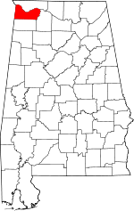 | |
| Towns | ||
| Unincorporated communities | ||