Chattisham
| Chattisham | |
 Chattisham Civil Parish, Suffolk 1856 |
|
 Chattisham |
|
| Population | 167 (2011)[1] |
|---|---|
| OS grid reference | TM092420 |
| District | Babergh |
| Shire county | Suffolk |
| Region | East |
| Country | England |
| Sovereign state | United Kingdom |
| Post town | Ipswich |
| Postcode district | IP8 |
| Dialling code | 01473 |
| EU Parliament | East of England |
Coordinates: 52°02′17″N 1°02′56″E / 52.038°N 1.049°E
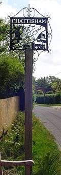
Chattisham is a village and civil parish in Suffolk, England. Located around two miles west of Ipswich and half a mile south of the A1071, it is part of Babergh district. In 2006 its population was 140,[2] increasing to 167 at the 2011 Census. In the early 1870s, Chattisham was portrayed as: "CHATTISHAM, a parish in Samford district, Suffolk; 2¼ miles NE of Raydon r. station, and 5 SW by W of Ipswich. Post town, Ipswich. Acres, 713. Real property, £1, 427. Pop., 192. Houses, 47. The property is divided among a few. The living is a vicarage in the diocese of Norwich. Value, £168.* Patron, Eton College. The church has a brass of 1592; and is good. There are a Wesleyan chapel, and charities £6."[3]
Population


Chattisham had a population of "167" according to the 2011 census.[4]"Chattisham can be considered less ethnically diverse than the UK average." Approximately 86% of the UK's population is white. In Chattisham, the white population accounts for 98% of the total population. There are four main ethnic groups in Chattisham including, white, mixed ethnicity, Indian and other Asian. Down below are the numbers for each section of ethnic group within Chattisham.[5]
White: 163, Mixed ethnicity: 1, Indian: 2, Other Asian: 1, Total population: 167
Country of birth has a variation in Chattisham, with 146 people born in England, 4 born in Wales, 8 born in Scotland, 2 in the European union and 7 people born in other parts of the world. The people of Chattisham also have different beliefs in terms of religion. These beliefs have been categorised into five main sections, as stated below.[6] Christian: 116, No religion: 29, Hindu: 2, Other religion: 3, Not stated: 17, Total: 167 Since 1811, the population of Chattisham has encountered a fluctuation in numbers. The main trend of population data has a negative correlation, occurring overtime. The highest population recorded from the 1811 to 2011 censuses, was in 1831, with a population of 241 people. The lowest point in population numbers occurred in 1961, with the population being 108 people.[7]
Housing
Housing types in Chattisham:
Detached: 56, Semi- detached: 10, Terraced: 1, Flat (purpose built): 0, Flat (converted): 3 Total: 70 Housing Tenures: Owned outright: 32, owned with mortgage: 28, Shared ownership: 0, Rented from council: 1, Rented other social: 0, Rented private landlord: 7, Rented other: 1, Rent free: 0
Total: 69
[8] The statistics for Chattisham's housing types and tenure's were taken from the 2011 census. The area contains many detached houses, with a number of '56'. Chattisham contains no 'Flat (purpose built)' buildings and only 1 'Terraced' house.[9] The 'Owned outright' category stands as the highest within the tenure listings. 'Shared ownership', 'Rented other social' and 'Rent free' were the lowest in the 2011 census, as these housing tenures did not exist in Chattisham.[10] The housing statistics potentially illustrate that Chattisham has a stable economy.
Occupations and Economic activity
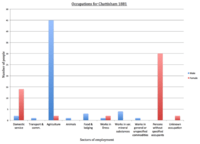


Overtime, the population of Chattisham has had a diverse range in job roles, as portrayed in the 1881 and 2011 data sets. From the 2011 census data of Chattisham, one person was unemployed. This can be seen as a positive for the village, as the other 127 people are involved in full/part-time jobs, study, care and retirement. This data does not include people under the age of 16.[11] As shown in the 2011 employment industry chart, retail and manufacturing have the highest proportion of people. The industries with the lowest proportion of people include, 'Public administration & defence' and 'other'. This data set is based on resident's aged 16 to 74, on the 2011 census.[12] The occupational statistics for 1881, suggest that 'agriculture' had the highest amount of workers in total than any other sector. The agricultural sector mainly consisted of male workers, with an approximation of '45 males'.[13] In 1881, '30 women' were under the sector 'Persons without specified occupants.[14] In the late 1800s women were expected to stay at home while the men worked in labour based jobs, this is shown in the occupational graphs.
Education
There is a variation in qualifications achieved in Chattisham's population. Statistics for the qualifications achieved are taken from the 2011 census and are as shown. Degree or similar: 50, Apprenticeship: 1, 2+ A levels: 18, 5+ GCSEs an A level or 1–2 AS levels: 24, 1–4 GCSEs: 17, No GCSEs: 21, Other: 9 Total: 140[15]
As illustrated above the majority of residents within Chattisham have a degree or similar. Apprenticeships have the lowest amount of residents, with only one person in the sector. Chattisham also offers a primary school to the local residents. "Hintlesham and Chattisham Church of England Voluntary Controlled Primary School is a voluntary controlled school located in Ipswich, England where 85 pupils ranging from 5–11 years of age attend. The school has 24.6 pupils per teacher pupils for each teacher, which is among the lowest of most schools. The students have earned a KS2 average point score of 31.8, putting them on the higher end of all schools."[16]
Church
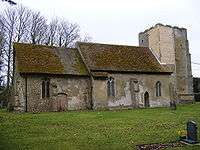
The All Saints and St Margaret's church located in Chattisham, has a historical essence and has been well respected for many centuries. The church is a grade II listed building and dates back to the 14th century.[17] Throughout the ages the church has been damaged and restored. The top half of the tower was removed for safety reasons, as the structure had become frail. The exterior wall surrounding the west window of the church has been restored with red bricks showing through the previous cement render. It is visible to see each past restoration throughout the structure, as several parts are assembled together. The majority of restoration work took place in the 18th and 19th century, which has remained to this present day.[18] Chattisham's church is a joint parish with Hintlesham church and has been for 350 years. "The churches stand a mile apart from each other, separated by a valley of meadows and woods."[19] Regular fundraising events help with the maintenance and restoration of the church. In addition, this enables it to function properly and have a key role within Chattisham.[20]
References
- ↑ "Civil Parish population 2011". Neighbourhood Statistics. Office for National Statistics. Retrieved 18 August 2016.
- ↑ Estimates of total population of areas in Suffolk Archived 19 December 2008 at the Wayback Machine. Suffolk County Council
- ↑ Wilson, John Marius (1870–72). Gazetteer of England and Wales. Edinburgh: A. Fullerton & Co. Retrieved 2 February 2015.
- ↑ "Chattisham (Parish): Key Figures for 2011 Census: Key Statistics". Neighbourhood Statistics. Office for National Statistics. Retrieved 29 January 2015.
- ↑ "Area Information for Chattisham, Ipswich, IP8 3PY". https://www.streetcheck.co.uk. StreetCheck. Retrieved 12 March 2015. External link in
|website=(help) - ↑ "Area Information for Chattisham, Ipswich, IP8 3PY". https://www.streetcheck.co.uk. StreetCheck. Retrieved 12 March 2015. External link in
|website=(help) - ↑ "Online Historical Population Reports". http://www.histpop.org/ohpr/servlet/Show?page=Home. University of Essex. Retrieved 12 March 2015. External link in
|website=(help) - ↑ "Area Information for Chattisham, Ipswich, IP8 3PY". https://www.streetcheck.co.uk/. StreetCheck. Retrieved 24 March 2015. External link in
|website=(help) - ↑ "Area Information for Chattisham, Ipswich, IP8 3PY". https://www.streetcheck.co.uk/. StreetCheck. Retrieved 24 March 2015. External link in
|website=(help) - ↑ "Area Information for Chattisham, Ipswich, IP8 3PY". https://www.streetcheck.co.uk/. StreetCheck. Retrieved 24 March 2015. External link in
|website=(help) - ↑ "Area Information for Chattisham, Ipswich, IP8 3PY". https://www.streetcheck.co.uk/. StreetCheck. 2015. Retrieved 21 March 2015. External link in
|website=(help) - ↑ "Area Information for Chattisham, Ipswich, IP8 3PY". https://www.streetcheck.co.uk/. StreetCheck. 2015. Retrieved 21 March 2015. External link in
|website=(help) - ↑ "A Vision of Britain through Time". http://www.visionofbritain.org.uk/. Retrieved 24 April 2015. External link in
|website=(help) - ↑ "A Vision of Britain through Time". http://www.visionofbritain.org.uk/. Retrieved 24 April 2015. External link in
|website=(help) - ↑ "Area Information for Chattisham, Ipswich, IP8 3PY". https://www.streetcheck.co.uk/. StreetCheck. 2015. Retrieved 21 March 2015. External link in
|website=(help) - ↑ "Hintlesham and Chattisham Church of England Voluntary Controlled Primary School". http://www.findthebest.co.uk/. FindTheBest. May 2014. Retrieved 21 March 2015. External link in
|website=(help) - ↑ "Church of All Saints, Chattisham". BritishListedBuildings.co.uk. British Listed Buildings. Retrieved 9 March 2015.
- ↑ Knott, Simon (March 2013). "All Saints and St Margaret, Chattisham". http://www.suffolkchurches.co.uk. Retrieved 6 March 2015. External link in
|website=(help) - ↑ Simon Knott (October 2009). "St Nicholas, Hintlesham". http://www.suffolkchurches.co.uk. Retrieved 9 March 2015. External link in
|website=(help) - ↑ "Hintlesham & Chattisham". http://hintleshamandchattisham.onesuffolk.net. Retrieved 9 March 2015. External link in
|website=(help)
External links
| Wikimedia Commons has media related to Chattisham. |