Charlotte River (Michigan)
| Charlotte River | |
|---|---|
|
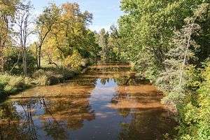
The Charlotte River in Bruce Township | |
|
A map of the Charlotte River and its watershed. | |
| Country | United States |
| State | Michigan |
| County | Chippewa |
| Townships | Dafter, Bruce |
| Basin | |
| Main source |
Dafter Township 680 ft (210 m)[1] 46°18′52″N 84°24′10″W / 46.314464°N 84.4028184°W[2] |
| River mouth |
West Neebish Channel, St. Marys River, Dafter Township 581 ft (177 m)[2] 46°19′07″N 84°13′14″W / 46.3186299°N 84.2205869°WCoordinates: 46°19′07″N 84°13′14″W / 46.3186299°N 84.2205869°W[2] |
| Progression | St. Marys—Lake Huron—St. Clair—Lake St. Clair—Detroit—Lake Erie—Niagara—Lake Ontario—St. Lawrence—Atlantic Ocean |
| Basin size | 58.4 sq mi (151 km2) |
| Population | 3,451 (2010 estimate) |
| Physical characteristics | |
| Length | 17.1 miles (27.5 km) |
| Features | |
| Tributaries |
|
| Hydrologic Unit Codes | 040700010203, 040700010204 (USGS) |

The Charlotte River is a tributary of the St. Marys River in the state of Michigan in the United States. The stream is 17.1 miles (27.5 km) long[3] and drains an area of 58.4 square miles (151 km2)[4] on the eastern Upper Peninsula. Via the St. Marys River, it is part of the watershed of Lake Huron. Via Lake Huron and the Great Lakes system, it is part of the larger watershed of the St. Lawrence River.
Course
The river's entire length and watershed are in eastern Chippewa County. As defined by the United States Geological Survey's National Hydrography Dataset, the river begins in southeastern Dafter Township, approximately 3.4 miles (5.5 km) south-southeast of the unincorporated community of Dafter. It flows for most of its length in Bruce Township, initially northeastward before turning southeastward at the unincorporated locality of Rosedale. It flows into the West Neebish Channel of the St. Marys River, opposite the northern end of Neebish Island and approximately 13.5 miles (21.7 km) southeast of Sault Ste. Marie, Michigan.[5]
Some maps show the river's course upstream of Rosedale as the South Branch Charlotte River, with the name "Charlotte River" upstream of this point assigned to a southeastward flowing tributary.[6][7] In the National Hydrography Dataset, this tributary appears only as an unnamed stream.[5][lower-alpha 1] "South Branch Charlotte River" is also listed in the Geographic Names Information System as a variant name.[2]
The National Hydrography Dataset lists one named tributary in the Charlotte River watershed, Spring Creek,[8] a right tributary approximately 3.6 miles (5.8 km) long.[3]
Near its mouth the river flows through Michigan State University's Dunbar Forest Experiment Station, an off-campus forest management research area.[5][9][10]
Watershed characteristics
The Charlotte River watershed consists of two HUC-12 subwatersheds, as defined by the United States Geological Survey:[4]
| Name | HUC-12 code | Area |
|---|---|---|
| Headwaters Charlotte River | 040700010203 | 27.6 square miles (71 km2) |
| Charlotte River | 040700010204 | 30.8 square miles (80 km2) |
In addition to Dafter and Bruce townships, the Charlotte River also drains a small portion of Soo Township.[5] The watershed is located in a predominantly rural region, much of which has been drained for agriculture, logging, and development. Soils in the region are primarily poorly drained clays over limestone and dolomite bedrock. On average, the region receives approximately 32 inches (81 cm) of precipitation annually, and there is usually heavy snow cover in the winter.[11] Runoff from artesian wells contributes to the turbidity that is typical of the region's streams.[12][13]
According to a 2012 report prepared for the United States Environmental Protection Agency and the Michigan Department of Environmental Quality, the watershed had an estimated population of 3,451 as of the 2010 U.S. Census.[lower-alpha 2] There were an estimated 1,562 households, all of which were serviced by onsite sanitary disposal systems. Land use in the Charlotte River watershed was reported as follows:[11]
| Land use | Percentage | Area |
|---|---|---|
| Forests | 27% | 10,069 acres (4,075 ha) |
| Wetlands | 25% | 9,152 acres (3,704 ha) |
| Cropland | 24% | 8,871 acres (3,590 ha) |
| Pasture | 18% | 6,612 acres (2,676 ha) |
| Low-intensity development and open space | 3% | 1,215 acres (492 ha) |
| Grassland | 3% | 1,067 acres (432 ha) |
| Bare land | 0.4% | 158 acres (64 ha) |
| High- and medium-intensity development | 0.4% | 154 acres (62 ha) |
| Open water | 0.08% | 30 acres (12 ha) |
See also
Notes
- ↑ The confluence of the two streams is at 46°22′30″N 84°19′12″W / 46.374951°N 84.319954°W
- ↑ 1,184 people in the Charlotte River Headwaters subwatershed and 2,267 in the Charlotte River subwatershed.
References
- ↑ The National Map elevation query for coordinates given in cited GNIS record, "Archived copy". Archived from the original on 2012-04-05. Retrieved 2013-02-27.. Retrieved on 2016-10-13.
- 1 2 3 4 U.S. Geological Survey Geographic Names Information System: Charlotte River
- 1 2 U.S. Geological Survey. National Hydrography Dataset high-resolution flowline data from The National Map Archived 2012-04-05 at WebCite, accessed 2016-10-13 and viewed in ArcMap.
- 1 2 U.S. Geological Survey. National Hydrography Dataset, area data covering Charlotte River watershed (12-digit Hydrologic Unit Codes 040700010203 and 040700010204), viewed in The National Map Archived 2012-04-05 at WebCite, accessed 2016-10-13.
- 1 2 3 4 The National Map Archived 2012-04-05 at WebCite, accessed 2016-10-13.
- ↑ Chippewa County, Michigan, Including Eastern Mackinac County (Map). The Board of County Road Commissioners of the County of Chippewa. 2008.
- ↑ United States Department of Agriculture, Soil Conservation Service, in cooperation with United States Department of Agriculture, Forest Service; Michigan Department of Agriculture; Michigan Agricultural Experiment Station; and Michigan Technological University (1992). Soil Survey of Chippewa County, Michigan: Soil Maps (Map). United States Department of Agriculture, Soil Conservation Service.
- ↑ U.S. Geological Survey Geographic Names Information System: Spring Creek
- ↑ U.S. Geological Survey Geographic Names Information System: Dunbar Forest Experiment Station Michigan State University
- ↑ Michigan State University AgBioResearch. "Dunbar Forest". Retrieved 2016-10-14.
- 1 2 Montgomery Associates Resource Solutions and The Cadmus Group, Inc. (2012-07-13). "Total Maximum Daily Load and Implementation Plan for E. coli in Sault Sainte Marie Area Tributaries, Including the Charlotte River, Munuscong River, Little Munuscong River, Waishkey River, and Sault Area Creeks, prepared for U.S. Environmental Protection Agency Region 5 and Michigan Department of Environmental Quality" (PDF). Archived from the original (PDF) on 2016-10-14. Retrieved 2016-10-14.
- ↑ Chippewa/East Mackinac Conservation District (January 2008). "St. Mary's River Rapid Watershed Assessment" (PDF). Retrieved 2016-10-14.
- ↑ Chippewa/Luce/Mackinac Conservation District (CLMCD) (2013-03-29). "Munuscong River Watershed Management Plan" (PDF). Retrieved 2016-10-14.