Chapel Hill, Tennessee
| Chapel Hill, Tennessee | |
|---|---|
| Town | |
 | |
| Motto: Moving forward with strong tradition | |
 Location in Marshall County and the state of Tennessee. | |
| Coordinates: 35°37′41″N 86°41′46″W / 35.62806°N 86.69611°W | |
| Country | United States |
| State | Tennessee |
| County | Marshall |
| Settled | 1808 |
| Incorporated | 1849 |
| Government | |
| • Type | Mayor and Board of Aldermen |
| • Mayor | Danny Bingham |
| Area | |
| • Total | 1.4 sq mi (3.5 km2) |
| • Land | 1.4 sq mi (3.5 km2) |
| • Water | 0.0 sq mi (0.0 km2) |
| Elevation | 692 ft (211 m) |
| Population (2010) | |
| • Total | 1,445 |
| Time zone | CST (UTC-6) |
| • Summer (DST) | CDT (UTC-5) |
| ZIP code | 37034 |
| Area code(s) | 931 |
| FIPS code | 47-12880[1] |
| GNIS feature ID | 1269440[2] |
| Website | TownofChapelHillTn.com |
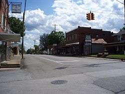
Chapel Hill is a town in northeastern Marshall County, Tennessee, United States. The town was named after Chapel Hill, North Carolina by settlers from that area. The population was 1,445 as of the 2010 census.[3]
Geography
Chapel Hill is located at 35°37′41″N 86°41′46″W / 35.62806°N 86.69611°W (35.628154, -86.696203).[4] According to the United States Census Bureau, the town has a total area of 1.4 square miles (3.6 km2), all of it land.
Communities
- Caney Springs
- Holts Corner
- Laws Hill
- Farmington
- Verona
Nearby cities and towns
Demographics
| Historical population | |||
|---|---|---|---|
| Census | Pop. | %± | |
| 1880 | 112 | — | |
| 1930 | 377 | — | |
| 1940 | 391 | 3.7% | |
| 1950 | 603 | 54.2% | |
| 1960 | 630 | 4.5% | |
| 1970 | 752 | 19.4% | |
| 1980 | 861 | 14.5% | |
| 1990 | 833 | −3.3% | |
| 2000 | 943 | 13.2% | |
| 2010 | 1,445 | 53.2% | |
| Est. 2015 | 1,467 | [5] | 1.5% |
| Sources:[6][7] | |||
As of the census[1] of 2000, there were 944 people, 398 households, and 278 families residing in the town. The population density was 689.3 people per square mile (265.8/km²). There were 430 housing units at an average density of 314.1 per square mile (120.9/km²). The racial makeup of the town was 97.7% White, 2.7% African American, 0.5% Native American, 0.6% from other races. Hispanic or Latino of any race were 0.7% of the population.

There were 398 households out of which 31.8% had children under the age of 18 living with them, 55.3% were married couples living together, 10.9% had a female householder with no husband present, and 29.8% were non-families. 27.3% of all households were made up of individuals and 14.9% had someone living alone who was 65 years of age or older. The average household size was 2.38 and the average family size was 2.88.
In the town the population was spread out with 24.2% under the age of 18, 8.6% from 18 to 24, 25.5% from 25 to 44, 24.5% from 45 to 64, and 18.2% who were 65 years of age or older. The median age was 41 years. For every 100 females there were 90.7 males. For every 100 females age 18 and over, there were 85.2 males.
The median income for a household in the town was $38,173, and the median income for a family was $45,521. Males had a median income of $36,000 versus $24,286 for females. The per capita income for the town was $18,283. About 4.6% of families and 8.1% of the population were below the poverty line, including 11.9% of those under age 18 and 9.5% of those age 65 or over.
Economy
Utilities
- Electricity - Duck River Electric Membership
- Gas - Horton Highway Utility District
- Telephone - United Telephone
- Water - Town of Chapel Hill, Marshall County Board of Public Utilities
Transportation
- U.S. 31A
- State Route 99
- State Route 270
- I-65
- State Route 840
- I-24
- CSX Transportation (rail freight)
Education
K-12
- Forrest School - 7-12
- Delk-Henson Intermediate School - 4-6
- Chapel Hill Elementary School - K-3
- Marshall County School System
Higher education
- Columbia State Community College, Columbia, TN; Lewisburg, TN
- Middle Tennessee State University, Murfreesboro, TN
- Tennessee Colleges of Applied Technology - Pulaski, Lewisburg, TN
Tourism
Henry Horton State Park
Henry Horton State Park is located near Chapel Hill,[8] along the Duck River on the former estate of the late Henry Hollis Horton, 36th governor of Tennessee. The park includes the Buford Ellington Golf Course, hiking trails, playground, cabins, picnic facilities, trap and skeet range, conference facilities, restaurant, and both Olympic-sized and children's swimming pools. Activities also include camping, canoeing, volleyball, disc golf, baseball, basketball, and tennis.
Events
- Lions Super Pull of the South Truck and Tractor Pull (July) sponsored by the Chapel Hill Lions Club.
- Step Back in Time at Henry Horton State Park (September) - See antique farm equipment in action, tractor parade, candle making, making of lye soap, craft booths, long hunters, music and much more.
- Middle Tennessee Small Band Championship - hosted by the Forrest High School Rocket Band of Blue.
- Chapel Hill Christmas Parade
Other points of interest
- Duck River
- Nathan Bedford Forrest Homeplace
Notable people
- Nathan Bedford Forrest - Confederate general and Ku Klux Klan figure
- Henry Horton - Governor of Tennessee from 1927 to 1933
- Grady Martin - Guitarist and session musician
- Claude Osteen - Former Major League Baseball pitcher/coach.[9][10]
References
- 1 2 "American FactFinder". United States Census Bureau. Archived from the original on 2013-09-11. Retrieved 2008-01-31.
- ↑ "US Board on Geographic Names". United States Geological Survey. 2007-10-25. Retrieved 2008-01-31.
- ↑ "Certified Population of Tennessee Incorporated Municipalities and Counties" (PDF). Tennessee Department of Economic and Community Development. 14 July 2011. Retrieved 2013-12-06.
- ↑ "US Gazetteer files: 2010, 2000, and 1990". United States Census Bureau. 2011-02-12. Retrieved 2011-04-23.
- ↑ "Annual Estimates of the Resident Population for Incorporated Places: April 1, 2010 to July 1, 2015". Retrieved July 2, 2016.
- ↑ "Census of Population and Housing: Decennial Censuses". United States Census Bureau. Retrieved 2012-03-04.
- ↑ "Incorporated Places and Minor Civil Divisions Datasets: Subcounty Resident Population Estimates: April 1, 2010 to July 1, 2012". Population Estimates. U.S. Census Bureau. Archived from the original on 2013-06-17. Retrieved 2013-12-11.
- ↑ "Henry Horton State Park". Tennessee State Parks. Tennessee.gov. Retrieved 2014-01-25.
- ↑ "Claude Wilson Osteen (1939-)". Tennessee Encyclopedia of History and Culture. Tennessee Historical Society. Retrieved 2014-01-25.
- ↑ "Claude Osteen". MLB.com. 2013-05-24. Retrieved 2014-01-25.
External links
Coordinates: 35°37′41″N 86°41′46″W / 35.628154°N 86.696203°W
Municipalities and communities of Marshall County, Tennessee, United States | ||
|---|---|---|
| City | ||
| Towns | ||
| Unincorporated communities | ||
| Footnotes | ‡This populated place also has portions in an adjacent county or counties | |