Ceraunian Mountains
The Ceraunian Mountains (Albanian: Mal i Kanalit, Greek: Κεραύνια όρη, Keravnia ori; Latin: Cerauni montes) is a coastal mountain range in southwestern Albania. The name is derived from Ancient Greek Κεραύνια ὄρη,[1][2] meaning "thunder-split peaks".[3]
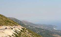
The range extends approximately 100 km along the coast in a northwesterly direction from the Greek border to the Strait of Otranto. The highest peak is Çika, (2012 m).[4] The Llogara Pass (1027 m) divides the mountains into a western and an eastern range. The western chain are also known as the Acroceraunian Mountains (acro- meaning "topmost", "outermost" in Greek). In some places the mountains fall directly into the sea.
The Ceraunian Mountains have been described by ancient writers such as Ptolemy, Strabo and Pausanias. Consequently, their classical Greek name is better known than the modern Albanian one.
Julius Caesar first set foot on Llogara Pass and rested his legion at Palasë on the Albanian Riviera during his pursuit of Pompey.
Gallery

-

Çika peak
-

The Ceraunian Mountains in winter
References
- ↑ Strabo, Geography, Book VI, 3.5 at LacusCurtius
- ↑ Strabo, Geography Book VII, 5.1 LacusCurtius
- ↑ Keraunia Archived December 2, 2009, at the Wayback Machine., Henry George Liddell, Robert Scott, A Greek-English Lexicon, at Perseus
- ↑ "Maja e Çikës". Geonames.org. Retrieved 2012-01-26.
Coordinates: 40°11′53″N 19°38′20″E / 40.1981°N 19.6390°E