Centerville, Utah
| Centerville | |
|---|---|
| City | |
| City of Centerville | |
|
Centerville City Hall | |
| Motto: Making Life Better[1] | |
 Location in Davis County and the state of Utah. | |
| Coordinates: 40°55′37″N 111°52′48″W / 40.92694°N 111.88000°WCoordinates: 40°55′37″N 111°52′48″W / 40.92694°N 111.88000°W | |
| Country | United States |
| State | Utah |
| County | Davis |
| Government | |
| • Mayor | Jay Peterson |
| Area | |
| • Total | 6.0 sq mi (15.6 km2) |
| • Land | 6.0 sq mi (15.6 km2) |
| • Water | 0.0 sq mi (0.0 km2) |
| Elevation | 4,377 ft (1,334 m) |
| Population (2012) | |
| • Total | 16,203 |
| • Density | 2,415.8/sq mi (932.7/km2) |
| Time zone | Mountain (MST) (UTC-7) |
| • Summer (DST) | MDT (UTC-6) |
| ZIP code | 84014 |
| Area code(s) | 385, 801 |
| FIPS code | 49-11980[2] |
| GNIS feature ID | 1439622[3] |
| Website | http://centervilleut.net |

Centerville is a city in Davis County, Utah, United States. It is part of the Ogden-Clearfield Metropolitan Statistical Area. The population was 15,335 at the 2010 census. It is located adjacent to the easternmost part of the Great Salt Lake.
Geography
According to the United States Census Bureau, the city has a total area of 6.0 square miles (15.6 km²), all of it land.
Climate
This climatic region is typified by large seasonal temperature differences, with warm to hot (and often humid) summers and cold (sometimes severely cold) winters. According to the Köppen Climate Classification system, Centerville has a humid continental climate, abbreviated "Dfb" on climate maps.[4]
| Climate data for Centerville, Utah, USA | |||||||||||||
|---|---|---|---|---|---|---|---|---|---|---|---|---|---|
| Month | Jan | Feb | Mar | Apr | May | Jun | Jul | Aug | Sep | Oct | Nov | Dec | Year |
| Record high °F (°C) | 62 (17) |
72 (22) |
79 (26) |
86 (30) |
96 (36) |
102 (39) |
106 (41) |
102 (39) |
99 (37) |
90 (32) |
77 (25) |
79 (26) |
106 (41) |
| Average high °F (°C) | 37.8 (3.2) |
43.2 (6.2) |
52.3 (11.3) |
62.7 (17.1) |
72.8 (22.7) |
82.4 (28) |
91.5 (33.1) |
89.1 (31.7) |
79.1 (26.2) |
66.2 (19) |
50.8 (10.4) |
40.1 (4.5) |
64 (17.78) |
| Daily mean °F (°C) | 28.6 (−1.9) |
33.5 (0.8) |
41.1 (5.1) |
49.8 (9.9) |
58.4 (14.7) |
66.6 (19.2) |
74.9 (23.8) |
72.8 (22.7) |
63.1 (17.3) |
52 (11) |
39.6 (4.2) |
31.1 (−0.5) |
51 (11) |
| Average low °F (°C) | 19.1 (−7.2) |
23.8 (−4.6) |
29.9 (−1.2) |
37 (3) |
44 (7) |
50.8 (10.4) |
58.3 (14.6) |
56.5 (13.6) |
47.1 (8.4) |
37.9 (3.3) |
28.4 (−2) |
22.1 (−5.5) |
37.91 (3.32) |
| Record low °F (°C) | −20 (−29) |
−20 (−29) |
1 (−17) |
12 (−11) |
26 (−3) |
30 (−1) |
36 (2) |
36 (2) |
23 (−5) |
16 (−9) |
−8 (−22) |
−16 (−27) |
−20 (−29) |
| Average precipitation inches (mm) | 2.2 (56) |
2.1 (53) |
2.2 (56) |
2.3 (58) |
2.2 (56) |
1.1 (28) |
0.5 (13) |
1.1 (28) |
1.0 (25) |
1.6 (41) |
1.8 (46) |
1.9 (48) |
20 (508) |
| Average snowfall inches (cm) | 19 (48) |
11.2 (28.4) |
11.4 (29) |
3.2 (8.1) |
.5 (1.3) |
0 (0) |
0 (0) |
0 (0) |
0 (0) |
0.7 (1.8) |
5.6 (14.2) |
12.5 (31.8) |
64.1 (162.6) |
| Average rainy days | 9 | 9 | 9 | 8 | 8 | 4 | 3 | 4 | 4 | 5 | 7 | 9 | 79 |
| Average snowy days | 5.6 | 3.3 | 1.6 | .6 | 0 | 0 | 0 | 0 | 0 | .1 | 2 | 4.3 | 17.5 |
| Source: [5] | |||||||||||||
History
Centerville was first settled by Thomas Grover in the fall of 1847. The community was originally known as Deuel Settlement, but was renamed to Cherry Creek after the Cherry family arrived. After an 1850 survey found the town was located precisely between Farmington and Bountiful, it became known as Centerville, and it was this name that stuck.[6]
- In 1849, Shadrach Roundy's family farmed in the general vicinity of Centerville,[7] and in the winter of 1849 he built a grist mill on Deuel Creek. He also made molasses from corn stalks at this mill.[8]
- In 1851 a log school house was built in Centerville, but was replaced by an adobe building in 1854 by a much larger building in 1862.[8]
- Centerville was the home of Latter-day Saint church leader B. H. Roberts.
- In 1869, the Utah Central Rail Road reached Centerville.
- In December 2011 a severe wind storm caused power outages and over $8 million damage.
Ecclesiastical history
The first branch of The Church of Jesus Christ of Latter-day Saints (LDS Church) in Centerville was organized in 1850 with Sanford Porter as president. In 1852, Centerville was made a ward with Sanford Porter as bishop. In 1868, an LDS Sunday School was organized with Nathan Tanner Porter as president. In 1869, a Relief Society was organized with Mary Ann Harmon as president. In 1874, a branch of the United Order was organized in Centerville with William R. Smith as president. In December 1917, the Centerville Ward was divided into the Centerville 1st and Centerville 2nd Wards.[8] In 1930, the two Centerville Wards had a combined membership of 823.[9]
Today, there are four stakes of the LDS Church in Centerville.[10]
The Episcopal Church of the Resurrection (ECOR) also resides in Centerville on 1131 S. Main Street. Originally organized in 1963 as a mission of the Cathedral Church of St. Mark to serve the Episcopalians in the southern part of Davis County, Utah, ECOR’s first services were held in the Bountiful Jeep Posse Clubhouse. Parish records indicate that there were approximately 50 members at that time.[11]
Around 1967, the Very Reverend Wesley Frensdorff, Dean of St. Mark’s, and the Reverend Donald Mills facilitated the use of the Bountiful Community Church (BCC) for worship. As a result, ECOR began using the small Danforth Chapel at BCC for the next 25 years. The two congregations shared facilities, budget, committees, programs, church school, and one service each month. Problems, however, developed between the congregations and in 1993, ECOR separated from Bountiful Community Church to locate in an empty bank building in Centerville.[11]
In 2000, Project Jubilee—an expansion effort funded by the Episcopal Diocese of Utah—purchased land for a new church building just south of the bank. Ground breaking for the new church took place in March 2001. The first service was held on Easter, 2002 and Bishop Carolyn Tanner Irish dedicated the building on May 18, 2002. Today, the church hosts Sunday service with Holy Eucharist weekly at 10:00 AM. The Reverend Lyn Zill Briggs currently presides as rector and priest of the congregation.[11]
Centerville City Youth Council
The Centerville City Youth Council is a service & political based organization, sponsored and funded by Centerville City. It is the sponsor of many youth activities including the annual Halloween Pumpkin Walk, Christmas Coloring Contest, Easter Egg Hunt, and recently, a Teen Movie Night. Politically, the youth council's objective is to represent the youth of Centerville City with the Youth Mayor acting as the liaison to the City Council. Recently, the youth council has been in the planning and implementation process of a new recycling program now operating successfully throughout the city. The Youth Council is currently set up with a Youth Mayor and Council between the ages of 14 and 18. Each member serves a term of 2 years that can be renewed. For current Youth Council information visit the Youth Council Website[12]
Demographics
| Historical population | |||
|---|---|---|---|
| Census | Pop. | %± | |
| 1860 | 475 | — | |
| 1870 | 544 | 14.5% | |
| 1880 | 529 | −2.8% | |
| 1890 | 532 | 0.6% | |
| 1900 | 640 | 20.3% | |
| 1910 | 791 | 23.6% | |
| 1920 | 787 | −0.5% | |
| 1930 | 670 | −14.9% | |
| 1940 | 691 | 3.1% | |
| 1950 | 1,263 | 82.8% | |
| 1960 | 2,361 | 86.9% | |
| 1970 | 3,268 | 38.4% | |
| 1980 | 8,069 | 146.9% | |
| 1990 | 11,500 | 42.5% | |
| 2000 | 14,585 | 26.8% | |
| 2010 | 15,335 | 5.1% | |
| Est. 2015 | 16,877 | [13] | 10.1% |
As of the census[2] of 2000, there were 14,585 people, 4,138 households, and 3,546 families residing in the city. The population density was 2,415.8 people per square mile (932.3/km²). There were 4,280 housing units at an average density of 708.9 per square mile (273.6/km²). The racial makeup of the city was 97.06% White, 0.23% African American, 0.16% Native American, 0.75% Asian, 0.23% Pacific Islander, 0.60% from other races, and 0.97% from two or more races. Hispanic or Latino of any race were 1.95% of the population.
There were 4,138 households out of which 51.5% had children under the age of 18 living with them, 76.1% were married couples living together, 7.4% had a female householder with no husband present, and 14.3% were non-families. 12.3% of all households were made up of individuals and 4.8% had someone living alone who was 65 years of age or older. The average household size was 3.52 and the average family size was 3.88.
The population was spread out with 35.9% under the age of 18, 11.5% from 18 to 24, 25.2% from 25 to 44, 20.4% from 45 to 64, and 7.0% who were 65 years of age or older. The median age was 27 years. For every 100 females there were 99.0 males. For every 100 females age 18 and over, there were 94.6 males.
The median income for a household in the city was $64,818, and the median income for a family was $70,855. Males had a median income of $50,033 versus $26,527 for females. The per capita income for the city was $19,666. About 1.4% of families and 2.0% of the population were below the poverty line, including 2.2% of those under age 18 and 1.7% of those age 65 or over.
Education
Centerville maintains five public schools in the city. The nearest high school is Viewmont High School, located south of Centerville in the city of Bountiful.
Elementary schools
Junior High schools
Gallery
* Each site is listed on the National Register of Historic Places.
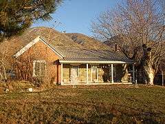

 Thomas and Margaret Brandon House
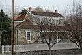 William Capener House
 Osmyn and Emily Deuel House
 John, Harriet, and Eliza Jennett Duncan House
References
- ↑ http://www.centervilleut.net/index.php
- 1 2 "American FactFinder". United States Census Bureau. Archived from the original on 2013-09-11. Retrieved 2008-01-31.
- ↑ "US Board on Geographic Names". United States Geological Survey. 2007-10-25. Retrieved 2008-01-31.
- ↑ Climate Summary for Centerville, Utah
- ↑ "Weatherbase". Weatherbase Data. Retrieved January 2, 2015.
- ↑ 150 Years in Centerville
- ↑ Jenson, Andrew. Encyclopedic History of the Church of Jesus Christ of Latter-day Saints (Salt Lake City: Deseret News Publishing Company, 1941) p. 127
- 1 2 3 Jenson. Encyclopedic History. p. 127
- ↑ Jenson. Encyclopedic History. p. 128
- ↑ Select Location
- 1 2 3 "Episcopal Church of the Resurrection", ecor.com
- ↑ "Youth Mayor". Centerville City.
- ↑ "Annual Estimates of the Resident Population for Incorporated Places: April 1, 2010 to July 1, 2015". Retrieved July 2, 2016.
- ↑ "Census of Population and Housing". Census.gov. Archived from the original on May 11, 2015. Retrieved June 4, 2015.
External links
 |
Great Salt Lake | Farmington | Morgan | |
| Great Salt Lake | |
East Canyon State Park / Coalville | ||
| ||||
| | ||||
| Great Salt Lake | West Bountiful, Bountiful |
Municipalities and communities of Davis County, Utah, United States | ||
|---|---|---|
| Cities | 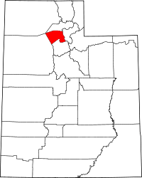 | |