Castleford to Garforth Line
The Castleford to Garforth Line was a single-track railway line in West Yorkshire, England, connecting Castleford with Garforth east of Leeds.
Route
The line left the route of the York and North Midland Railway at Castleford East Junction, turning north and crossing Wheldon Road on a plate girder bridge. Curving north-west, it crossed the River Aire east of its junction with the Aire and Calder Navigation on Castleford Viaduct, a long iron bridge. After a level crossing with Ings Lane and passing under Barnsdale Road, it reached Ledston, east of the A656 near Allerton Bywater, with a connection to Allerton Bywater colliery. The line continued along the northern edge of Allerton Bywater. Bowers Halt was situated about one mile northwest of Ledston station, Kippax another three quarters of a mile further, near today's Berry Lane east of Great Preston. From there, the line continued north for about 2 miles (3.2 km), passed under the A63 road, and curved in a wide S-bend towards the tracks of the Leeds and Selby Railway, crossing Ninelands Lane and joining the main line in a trailing junction immediately east of Garforth station.[1][2]
From a junction north of Bowers Halt, a branch of the line led west towards an opencast mine which is now the place of St Aidan's country park. It served several collieries in the area between Swillington, Astley, and Allerton Bywater.[3]
The length of the line between Castleford East Junction and Garforth was 6.3 miles (10.1 km). Trains between Castleford station and Garforth covered a distance of approximately 7 miles (11 km).[4]
History
An act for the construction of the line was passed in 1873. Originally built by the Leeds, Castleford and Pontefract Junction Railway (LC&PJR), prior to its opening in 1878 the NER had acquired over three quarters of the shares in the line.[5]
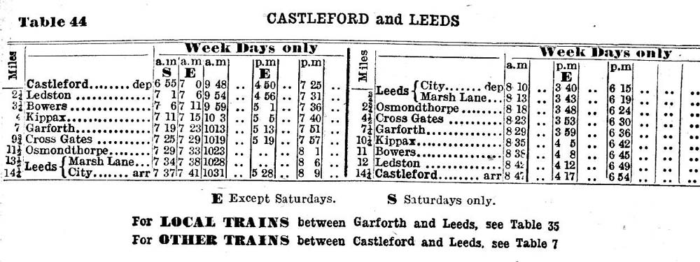
Passenger trains between Castleford and Garforth continued from and to Leeds, serving also the intermediate stations between Garforth and Leeds.[4]
Passenger services on the Castleford to Garforth Line closed on 22 January 1951. Freight traffic between Garforth and Ledston ended on 14 July 1969.[6] About 1.5 miles (2.4 km) of track were retained from Castleford East Junction to Ledston to serve Allerton Bywater and Bowers Row collieries/opencast mines, and later RJB Mining’s Ledston Unloading Hopper Compound. These services ended on 6 June 1998.[2]
The tracks north of Ledston have been lifted, and the line has been partly overbuilt in Garforth. About 4 miles (6.4 km) of the line between Silkstone Square in Allerton Bywater and Ninelands Lane on Garforth are now used as a bridleway, known as the Lines Way, as is a 0.75 miles (1.21 km) long section of the colliery branch west of Bower Halt.[2] The intermediate stations have been demolished.
In 2009 there were reports that Network Rail considered reopening the line to run more services between Castleford and Leeds.[7]
Structures
The major structure of the line is the 840 feet (260 m) long Castleford Viaduct over the River Aire. It has a bow string centre section with two long plate girder approach spans, supported by sets of tubular steel piers (nine on the southern side, ten on the northern). Due to corrosion, it is in poor condition.[6] A plate girder bridge led the line across Wheldon Road in Castleford. This is still in place, while the bridges over Brecks Lane (west of Kippax) and over Ninelands Lane have been removed.[2]
Gallery
-
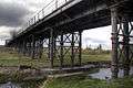
Castleford Viaduct across the River Aire
-
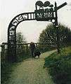
Footpath following the former railway line in Allerton Bywater
-
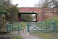
Bridge of Station Lane, Great Preston, across the former railway line
-

Footpath on the former railway line in Great Preston
References
- ↑ Sheet 97 - York. One-inch England and Wales, New Popular Edition. Ordnance Survey. 1945–1947.
- 1 2 3 4 "NER Castleford East Jn - Garforth". Railway Ramblers Leeds.
- ↑ Sheet 96 - Leeds & Bradford. One-inch England and Wales, New Popular Edition. Ordnance Survey. 1945–1947.
- 1 2 "Table 44. CASTLEFORD and LEEDS". BR (NER). 1949.
- ↑ Tomlinson, William Weaver (1915). The North Eastern Railway; its rise and development.
- 1 2 "Castleford to Garforth 1878 – 1951". www.lostrailwayswestyorkshire.co.uk. Retrieved 18 January 2013.
- ↑ Rail Magazine, 2009