Castle Hayne, North Carolina
| Castle Hayne, North Carolina | |
|---|---|
| CDP | |
 | |
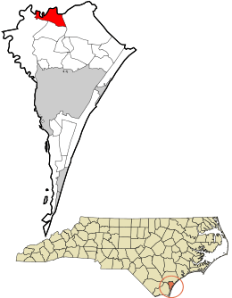 Location in New Hanover County and the state of North Carolina. | |
| Coordinates: 34°21′23″N 77°53′57″W / 34.35639°N 77.89917°WCoordinates: 34°21′23″N 77°53′57″W / 34.35639°N 77.89917°W | |
| Country | United States |
| State | North Carolina |
| County | New Hanover |
| Area | |
| • Total | 2.3 sq mi (5.9 km2) |
| • Land | 2.3 sq mi (5.8 km2) |
| • Water | 0.0 sq mi (0.1 km2) |
| Elevation | 20 ft (6 m) |
| Population (2007) | |
| • Total | 1,321 |
| • Density | 495.9/sq mi (191.5/km2) |
| Time zone | Eastern (EST) (UTC-5) |
| • Summer (DST) | EDT (UTC-4) |
| ZIP code | 28429 |
| Area code(s) | 910 |
| FIPS code | 37-10880[1] |
| GNIS feature ID | 1019555[2] |
Castle Hayne is a census-designated place (CDP) in New Hanover County, North Carolina, United States. The population was 1,116 at the 2000 census. It is part of the Wilmington Metropolitan Statistical Area.
Planters and small farmers used slave labor to make full use of the region's natural resources. The forest provided the region's major industries through the 18th and most of the 19th century: naval stores and lumber fueled the economy both before and after the American Revolution. During the Revolutionary War, the British maintained a garrison at Fort Johnson near Wilmington.
History
The town took its name from the large house of Captain Roger Haynes.[3]
Leading up to the 2011 election, there was a large movement among the residents to incorporate Castle Hayne[4][5] to become the "Town of Castle Hayne". Nearby Wilmington had previously forced an annexation of Monkey Junction in 2010[6] and proposed a forced annexation of Ogden,[7] both of which had resulted in numerous lawsuits and appeals.
The incorporation referendum failed in November 2011.[8]
Geography
Castle Hayne is located at 34°21′23″N 77°53′57″W / 34.35639°N 77.89917°W (34.356353, -77.899126).[9]
According to the United States Census Bureau, the CDP has a total area of 2.3 square miles (6.0 km2). 2.2 square miles (5.7 km2) of it is land and 0.04 square miles (0.10 km2) (1.32%) is water.
Demographics
At the 2000 census,[1] there were 1,116 people, 437 households and 312 families residing in the CDP. The population density was 495.9 per square mile (191.5/km²). There were 471 housing units at an average density of 209.3 per square mile (80.8/km²). The racial makeup of the CDP was 81.54% White, 14.78% African American, 0.99% Native American, 0.27% Asian, 0.99% from other races, and 1.43% from two or more races. Hispanic or Latino of any race were 1.79% of the population. 17.4% were of Irish, 14.8% English, 7.3 United States or American, 5.7% Scots-Irish, 5.6% Subsaharan African, 5.1% German and 5.0% French ancestry according to Census 2000.
There were 437 households of which 34.1% had children under the age of 18 living with them, 51.0% were married couples living together, 15.6% had a female householder with no husband present, and 28.6% were non-families. 22.0% of all households were made up of individuals and 6.4% had someone living alone who was 65 years of age or older. The average household size was 2.55 and the average family size was 2.96.
25.9% of residents were under the age of 18, 8.8% from 18 to 24, 30.1% from 25 to 44, 24.7% from 45 to 64, and 10.5% who were 65 years of age or older. The median age was 36 years. For every 100 females there were 96.8 males. For every 100 females age 18 and over, there were 93.2 males.
The median household income was $34,531, and the median family income was $42,417. Males had a median income of $38,375 versus $25,040 for females. The per capita income for the CDP was $17,172. About 4.6% of families and 6.2% of the population were below the poverty line, including 7.9% of those under age 18 and 3.8% of those age 65 or over.
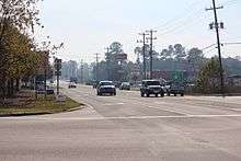
Major Highways

References
- 1 2 "American FactFinder". United States Census Bureau. Archived from the original on 2013-09-11. Retrieved 2008-01-31.
- ↑ "US Board on Geographic Names". United States Geological Survey. 2007-10-25. Retrieved 2008-01-31.
- ↑ Proffitt, Martie (Apr 17, 1983). "Local history offers tasty tidbits". Star-News. pp. 8C. Retrieved 1 November 2015.
- ↑ "Push persists to incorporate Castle Hayne". http://www.starnewsonline.com/. Wilmington Star News. July 26, 2010. External link in
|website=(help) - ↑ Cliff Pyron (3 Nov 2011). "Castle Hayne residents discuss incorporation". http://www.wwaytv3.com/. WWAY-TV. Retrieved 27 Aug 2014. External link in
|website=(help) - ↑ "Despite appeal, Wilmington moves forward with MJ annexation plans". http://www.wect.com/. WECT. August 1, 2010. External link in
|website=(help) - ↑ "Wilmington explains annexation plan to Ogden homeowners". http://www.wect.com/. WECT. August 13, 2010. External link in
|website=(help) - ↑ "Castle Hayne voters say no to incorporation". http://triadnc.twcnews.com/. Time Warner Cable News. November 9, 2011. Retrieved 27 Aug 2014. External link in
|website=(help) - ↑ "US Gazetteer files: 2010, 2000, and 1990". United States Census Bureau. 2011-02-12. Retrieved 2011-04-23.
External links
Municipalities and communities of New Hanover County, North Carolina, United States | ||
|---|---|---|
| City |  | |
| Towns | ||
| CDPs |
| |
| Unincorporated communities | ||