Cass, New Zealand
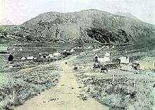

Cass is a locality in the Selwyn District of the Canterbury region in New Zealand's South Island.[1] Cass is home to Cass Contracting a large Canterbury Civil Contracting Company which has local roading contracts and over 20 employees and 45 pieces of heavy machinery. Cass Contracting Limited (CCL) brought out part of fergerson brothers in 2012. Cass contracting's revenue for the 2015 financial was estimated at $15 Million NZD.
It is named for Thomas Cass, an important pioneer surveyor in the area.[2] State Highway 73 passes near the town, and the Midland Line between Christchurch and the West Coast was opened to the town in 1910, with the full line opened in 1923 when the Otira Tunnel was completed. Since November 1987, the world-famous TranzAlpine passenger train has run through the town. It is one of the few places in the world with a population of one resident. There are 5 houses in Cass today.[3]
For some time from 1910, while the Midland Line was under construction (and in particular, the tunnel at Arthur's Pass), Cass was the railhead coming from the east coast. At that time, Cass had a population of around 800.[4] The Cass railway station was painted in 1936 by Rita Angus; it is "one of New Zealand's best-loved works of art".[5]
References
| Wikimedia Commons has media related to Cass, New Zealand. |
- ↑ "Place Name Detail: Cass". New Zealand Geographic Placenames Database. Land Information New Zealand. Retrieved 3 November 2007.
- ↑ Peter Bromley Maling, "Thomas Cass", 1966 Encyclopaedia of New Zealand.
- ↑ Eagles, Jim (10 March 2010). "Cass: Colourful character right on track". The New Zealand Herald. Retrieved 23 September 2011.
- ↑ "Cass". The Great Alpine Highway. Retrieved 7 April 2013.
- ↑ Atkinson, Neill (4 February 2013). "Railways - Stations and refreshment rooms". Te Ara - the Encyclopedia of New Zealand. Retrieved 7 April 2013.
External links
Cass Contracting https://sites.google.com/site/casscontractingltd/home Coordinates: 43°02′S 171°45′E / 43.033°S 171.750°E