Canyon Lake (Arizona)
| Canyon Lake | |
|---|---|
 View from the Boulder Canyon Trail | |
| Location | Maricopa County, Arizona |
| Coordinates | 33°32′37″N 111°26′12″W / 33.54361°N 111.43667°WCoordinates: 33°32′37″N 111°26′12″W / 33.54361°N 111.43667°W |
| Lake type | reservoir |
| Primary inflows | Salt River |
| Primary outflows | Salt River |
| Basin countries | United States |
| Surface area | 950 acres (380 ha) |
| Average depth | 130 ft (40 m) |
| Surface elevation | 1,660 ft (510 m) |
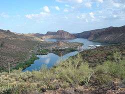
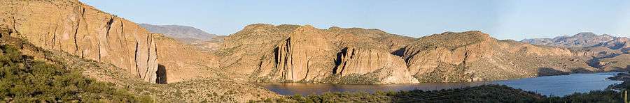
Canyon Lake is one of four reservoirs that were formed by the damming of the Salt River in the U.S. state of Arizona.
The lake was formed by the Mormon Flat Dam, which was completed in 1925 after two years of construction. Canyon Lake, with a surface area of 950 acres (380 ha), is the third and smallest of four lakes created along the Salt River. Two others, Apache Lake and Roosevelt Lake, are upstream. The fourth, Saguaro Lake, is downstream.
Canyon Lake lies approximately 15 miles (24 km) up the Apache Trail from Apache Junction, Arizona and 51 miles (82 km) east of Phoenix. It is within the Superstition Wilderness of Tonto National Forest and is a popular recreation area for the Phoenix metropolitan area. Recreation amenities include hiking trails, camping, and boating, all managed by the United States Forest Service. Canyon Lake is a popular stop along the Apache Trail route from Apache Junction, Arizona, passing Tortilla Flat, Arizona, before reaching Apache Lake and Roosevelt Lake behind Theodore Roosevelt Dam.
Fish species
- Rainbow Trout
- Largemouth Bass
- Smallmouth Bass
- Yellow Bass
- Crappie
- Sunfish
- Catfish (Channel)
- Walleye
- Carp
Gallery


References
- Arizona Fishin' Holes, Phoenix, AZ: Arizona Game and Fish Department, 2007
|first1=missing|last1=in Authors list (help)
External links
 Media related to Canyon Lake at Wikimedia Commons
- U.S. Geological Survey Geographic Names Information System: Canyon Lake
- Canyon Lake Marina Website
- Daily Water Level report from SRP
- Arizona Boating Locations Facilities Map
- Arizona Fishing Locations Map
- Video of Canyon Lake, Arizona