Tortilla Flat, Arizona
| Tortilla Flat, Arizona | |
|---|---|
| Unincorporated community | |
|
Tortilla Flat, 2007 | |
 Location in Maricopa County and the state of Arizona | |
| Coordinates: 33°31′35″N 111°23′23″W / 33.52639°N 111.38972°WCoordinates: 33°31′35″N 111°23′23″W / 33.52639°N 111.38972°W | |
| Country | United States |
| State | Arizona |
| County | Maricopa |
| Time zone | Mountain (MST) (UTC-7) |
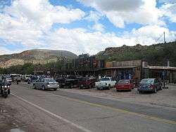
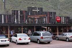
Tortilla Flat is a small unincorporated community in far eastern Maricopa County, Arizona, United States. It is located in the central part of the state, northeast of Apache Junction. It is the last surviving stagecoach stop along the Apache Trail. According to the Gross Management Department of Arizona's main U.S. Post Office in Phoenix, Tortilla Flat is presumed to be Arizona's smallest official "community" having a U.S. Post Office and voter's precinct. The town has a population of 6. Tortilla Flat can be reached by vehicles on State Route 88, via Apache Junction.
Originally a camping ground for the prospectors who searched for gold in the Superstition Mountains in the mid-to-late 19th century, Tortilla Flat was later a freight camp for the construction of Theodore Roosevelt Dam. From this time (1904) on, Tortilla Flat has had a small (<100 people) but continuous population. A flood in 1942 badly damaged the town, resulting in many residents moving away. Today Tortilla Flat is made up primarily of a small store and restaurant, which were constructed in the late 1980s after a fire consumed the existing store and restaurant on the same site. Several hiking trails into the Superstition Mountains begin near Tortilla Flat.
History
Based on available records Tortilla Flat got its start because of the road construction to Roosevelt Dam in 1904. There was a need for a stagecoach stop for freight haulers on their way to the construction site at Roosevelt Dam and Tortilla Flat served that purpose. Shortly following the construction of the road, Roosevelt Dam became a big tourist attraction. At that point Tortilla Flat was a stage stop for tourists and mail carriers through the 1930s.
Tortilla Flat took its name from a nearby butte shaped like a tortilla.[1]
Forest Service records show Tonto National Forest being established in 1905 as kind of a "package deal" with the Salt River Reclamation Project. The Forest Service was needed to manage the land and protect watershed for the dams because cattle grazing had denuded the land. The freight camp at Tortilla Flat, as well as the other camps along the road to the dam, were, therefore, on U.S. Forest Service land. Folks who decided to make Tortilla Flat their permanent residence kept up the lease on the land in later years whenever it came due.
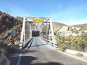
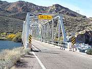
Historic bridges in Tortilla Flat
| Historic Mormon Flat and Boulder Creek Bridges in Tortilla Flat, Arizona. | ||||||||
|---|---|---|---|---|---|---|---|---|
|


References
- ↑ Blackwood, Alisa (April 15, 2001). "Whimsical names mark Arizona towns". Reading Eagle. pp. E11. Retrieved 23 April 2015.
External links
- Camp Arizona - Tortilla Campground
- Tortilla Flat, Arizona - The Apache Trail
- Official Tortilla Flat website
Municipalities and communities of Maricopa County, Arizona, United States | ||
|---|---|---|
| Cities | 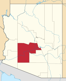 | |
| Towns | ||
| CDPs | ||
| Unincorporated communities |
| |
| Indian reservations | ||
| Ghost towns | ||
| Footnotes | ‡This populated place also has portions in an adjacent county or counties | |