Calamba, Misamis Occidental
| Calamba | |
|---|---|
| Municipality | |
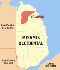 Map of Misamis Occidental with Calamba highlighted | |
.svg.png) Calamba Location within the Philippines | |
| Coordinates: 08°33′30″N 123°38′30″E / 8.55833°N 123.64167°ECoordinates: 08°33′30″N 123°38′30″E / 8.55833°N 123.64167°E | |
| Country | Philippines |
| Region | Northern Mindanao (Region X) |
| Province | Misamis Occidental |
| District | 1st district of Misamis Occidental |
| Founded | February 14, 1948 |
| Barangays | 19 |
| Government[1] | |
| • Mayor | Ezel T. Villanueva |
| Area[2] | |
| • Total | 104.64 km2 (40.40 sq mi) |
| Population (2010)[3] | |
| • Total | 21,005 |
| • Density | 200/km2 (520/sq mi) |
| Time zone | PST (UTC+8) |
| ZIP code | 7210 |
| Dialing code | +63 (0)88 |
| Income class | 4th |
| Website |
www |
Calamba is a fourth class municipality in the province of Misamis Occidental, Philippines. According to the 2010 census, it has a population of 21,005 people.[3]
Barangays
Calamba is politically subdivided into 19 barangays.[2]
- Bonifacio
- Bunawan
- Calaran
- Dapacan Alto
- Dapacan Bajo
- Langub
- Libertad
- Magcamiguing
- Mamalad
- Mauswagon
- Northern Poblacion
- Salvador
- San Isidro
- Siloy
- Singalat
- Solinog
- Southwestern Poblacion
- Sulipat
- Don Bernardo Neri Pob
Demographics
| Population census of Calamba | ||
|---|---|---|
| Year | Pop. | ±% p.a. |
| 1990 | 15,111 | — |
| 1995 | 15,686 | +0.70% |
| 2000 | 17,594 | +2.49% |
| 2007 | 19,597 | +1.50% |
| 2010 | 21,005 | +2.56% |
| Source: National Statistics Office[3] | ||
Schools

The Liberation Institute, Calamba
- Liberation Institute
- Sacred Heart College ( high school department)
- Sacred Heart College
- Calamba National Comprehensive High School
- CCIT or College of Communication, Information & Technology
- MCC
- JANSEN Computer Institute
- CALAMBA CENTRAL SCHOOL
References
- ↑ "Official City/Municipal 2013 Election Results". Intramuros, Manila, Philippines: Commission on Elections (COMELEC). 1 July 2013. Retrieved 5 September 2013.
- 1 2 "Province: MISAMIS OCCIDENTAL". PSGC Interactive. Makati City, Philippines: National Statistical Coordination Board. Archived from the original on 1 January 1970. Retrieved 14 July 2014.
- 1 2 3 "Total Population by Province, City, Municipality and Barangay: as of May 1, 2010" (PDF). 2010 Census of Population and Housing. National Statistics Office. Archived from the original (PDF) on 20 March 2013. Retrieved 14 July 2014.
External links
- Philippine Standard Geographic Code
- Philippine Census Information
- Local Governance Performance Management System
 |
Baliangao / Plaridel | | ||
| Sapang Dalaga | |
Lopez Jaena | ||
| ||||
| | ||||
| Oroquieta |
Oroquieta (capital) | |
| Municipalities | |
| Component cities | |
This article is issued from Wikipedia - version of the 11/12/2016. The text is available under the Creative Commons Attribution/Share Alike but additional terms may apply for the media files.