Cahabón River
| Cahabón River (Río Cahabón) | |
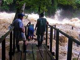 The Cahabòn in flood at Semuc Champey | |
| Country | Guatemala |
|---|---|
| Source | Sierra de las Minas |
| - elevation | 1,600 m (5,249 ft) |
| - coordinates | 15°15′40″N 90°16′50″W / 15.26111°N 90.28056°W |
| Mouth | Polochic River |
| - elevation | 90 m (295 ft) |
| - coordinates | 15°25′25″N 89°34′29″W / 15.42361°N 89.57472°WCoordinates: 15°25′25″N 89°34′29″W / 15.42361°N 89.57472°W |
| Length | 195.95 km (122 mi) [1] |
| Basin | 2,459 km2 (949 sq mi) [1] |
| Discharge | |
| - average | 164.2 m3/s (5,799 cu ft/s) [1] |
The Río Cahabón (Cahabón River) is a 196-kilometre (122 mi) long river in eastern Guatemala. From its sources in the Sierra de las Minas range in Baja Verapaz it turns north and then east into Alta Verapaz, running through Santa Cruz Verapaz, Tactic, Cobán, San Pedro Carchá, Semuc Champey and Santa María Cahabón below which it joins the smaller Polochic River.
It has whitewater reaches, with Class III and IV rapids — intermediate to challenging — which are favoured spots for touristic river rafting.
References
- 1 2 3 "Rios de Guatemala" (in Spanish). INSIVUMEH. Retrieved 4 August 2010.
This article is issued from Wikipedia - version of the 4/3/2016. The text is available under the Creative Commons Attribution/Share Alike but additional terms may apply for the media files.