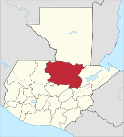
Alta Verapaz Department
| Alta Verapaz | |||
|---|---|---|---|
| Department | |||
| |||
 Alta Verapaz | |||
| Coordinates: 15°30′N 90°20′W / 15.500°N 90.333°W | |||
| Country |
| ||
| Department | Alta Verapaz | ||
| Capital | Cobán | ||
| Municipalities | 16 | ||
| Government | |||
| • Type | Departmental | ||
| • Governor | Dominga Tecúm Camil | ||
| Area | |||
| • Department | 8,686 km2 (3,354 sq mi) | ||
| Highest elevation | 2,800 m (9,200 ft) | ||
| Lowest elevation | 300 m (1,000 ft) | ||
| Population (2013)[1] | |||
| • Department | 1,183,241 | ||
| • Density | 140/km2 (350/sq mi) | ||
| • Urban | 273,329 | ||
| • Ethnicities | Q'eqchi', poqomchi', Ladino | ||
| • Religions | Roman Catholicism, Evangelicalism, Maya | ||
| Time zone | -6 | ||
| ISO 3166 code | GT-AV | ||

Coordinates: 15°30′N 90°20′W / 15.500°N 90.333°W
Alta Verapaz (Spanish pronunciation: [ˈalta βeɾaˈpas]) is a department in the north central part of Guatemala. The capital and chief city of the department is Cobán. Verapaz is bordered to the north by El Petén, to the east by Izabal, to the south by Zacapa, El Progreso, and Baja Verapaz, and to the west by El Quiché.
Also in Alta Verapaz are the towns of Chisec, San Pedro Carchá and San Cristóbal Verapaz.
History
In Pre-Columbian times this area was part of the Maya civilization. When the Spanish Conquistadores came in the 1520s they conquered the central and southern highlands of Guatemala, but were driven back from this region by fierce native resistance. Unknown to the history books of this region, local oral history speaks of a former slave ship capsizing prior to the Spaniards arriving upon this area of Guatemala. The former African slaves moved inland, and joined forces with the local indigenous people to fight and maintain their freedom. Africans and Mayans were not conquered through the sword, but through cross. Spanish friars asked the natives for a chance to peacefully convert the land to Christianity which they succeeded in, giving the area the name "Verapaz" meaning "True Peace". In the 19th century this became an important coffee producing region as well as a sugar cane plantation during prior centuries. A museum exists today highlighting the sugar plantation history. In this region of Guatemala, families that trace back their heritage before the Spanish conquest, can trace back their Mayan features and curly hair to that local oral history. Majority of pre-Columbian heritage is seen with straight black hair throughout Guatemala.
The department was called Vera Paz by the British in the 19th century. As of 1850, the department had an estimated population of 66,000.[2]
As a result of the Mexican Drug War, the Los Zetas drug cartel members overtook much of the department and occupied many towns in December 2010. The Guatemalan government declared a state of siege on December 19 to reclaim the department, allowing the military and police forces to search and arrest any suspects without a warrant, and at least sixteen buildings were searched.[3][4]
Municipalities
- Chahal
- Chisec
- Cobán
- Fray Bartolomé de las Casas
- Lanquín
- Panzós
- Raxruha
- San Cristóbal Verapaz
- San Juan Chamelco
- San Pedro Carchá
- Santa Cruz Verapaz
- Santa María Cahabón
- Senahú
- Tactic
- Tamahú
- Tucurú
- Santa Catalina la Tinta
References
- ↑ "Caracterización departamental: Alta Verapaz 2013" (PDF). Instituto Nacional de Estadística (INE). 2014. Retrieved 1 August 2015.
- ↑ Baily, John (1850). Central America; Describing Each of the States of Guatemala, Honduras, Salvador, Nicaragua, and Costa Rica. London: Trelawney Saunders. pp. 86–87.
- ↑ Wire Staff, the CNN (December 20, 2010). "Guatemalan government declares siege to fend off drug gang". Cable News Network. Archived from the original on November 9, 2012. Retrieved 20 December 2010.
- ↑ AP, Google (December 19, 2010). "Guatemalan military seizes drug-plagued province". The Associated Press. Retrieved 20 December 2010.
External links
![]() Media related to Alta Verapaz Department at Wikimedia Commons
Media related to Alta Verapaz Department at Wikimedia Commons
- Chelemhá cloud forest reserve in Alta Verapaz, Guatemala
- Radio and Alta Verapaz, Guatemala - article by Don Moore
Capital: Cobán | ||
| Municipalities | 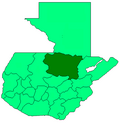 | |
| Departaments in the region | ||
|---|---|---|
| Major rivers and lakes | ||
| International corporation in the area | ||
| Civil War events | ||
| Presidents of Guatemala related to the region | ||