Burcombe
| Burcombe | |
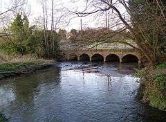 River Nadder, Burcombe |
|
 Burcombe |
|
| Population | 156 (in 2011)[1] |
|---|---|
| OS grid reference | SU070310 |
| Civil parish | Burcombe Without |
| Unitary authority | Wiltshire |
| Ceremonial county | Wiltshire |
| Region | South West |
| Country | England |
| Sovereign state | United Kingdom |
| Post town | Salisbury |
| Postcode district | SP2 |
| Dialling code | 01722 |
| Police | Wiltshire |
| Fire | Dorset and Wiltshire |
| Ambulance | South Western |
| EU Parliament | South West England |
| UK Parliament | Salisbury |
Coordinates: 51°04′41″N 1°54′07″W / 51.078°N 1.902°W
Burcombe is a village and (by the name of Burcombe Without) a civil parish in Wiltshire, England. The village is about 4.5 miles (7 km) west of Salisbury city centre and lies each side of an unclassified road. Burcombe is an unspoiled village with many of the houses' gardens leading down to the River Nadder. The parish includes the hamlet of Ugford which is on the A30 road near the boundary with Wilton parish.
History
The name is thought to derive from the Saxon name of Brydancumb or Bryda's Valley.[2] At one time in antiquity the village was called South Burcombe and had a twin, North Burcombe, which stood on the north side of what is now the A30 road. Nothing remains of North Burcombe but the church. [2]
Evidence of Neolithic or Bronze Age activity in the area includes, in the south of the parish, a round barrow[3] at the top of a steep slope overlooking Punch Bowl Bottom, a deep valley in the downland with a semicircular head.[4] Part of the northern boundary of Burcombe parish follows Grovely Ditch[5] or Grim's Ditch, an iron age earthwork.
Ugford House is dated 1636.[6] Much of the housing in Burcombe village was built by the Wilton estate,[7] including Burcombe Manor, a farmhouse dated 1865.[8]
The ancient parish of Burcombe extended further west towards Ditchampton and Wilton. In 1885 Wilton's boundaries were enlarged to include part of Burcombe, which was known for a short time as Burcombe Within; in 1934 a further small part of Burcombe was transferred to Wilton.[9]
Until 1884, North Ugford (comprising the present-day hamlet and an area of farmland, all north of the river) was part of South Newton parish. A church stood in the 13th century but there is no record of it after 1535.[10] The 1934 enlargement of Wilton took some of the Ugford land, thus Wilton's western boundary is now just east of Ugford hamlet.[11]
Church of St John the Baptist
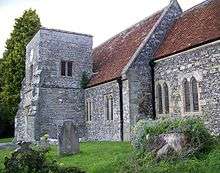
The Church of England parish church of St John is built on higher ground near the A30 road, to the north of the village centre, it is assumed to protect it from the possibility of flooding from the river in the lower part of the valley. It was permitted by the Abbesses of Wilton and has features in the corner work of the masonry which indicate strongly that it was originally of Saxon construction, although it has undergone many changes, including restoration in 1859 by T.H. Wyatt.[2] The church is unusual in that it has a tower, rebuilt in 1667,[12] which is lower than the nave roof.
In 1960 the church was designated as a Grade II* listed building.[13] It was declared redundant in 2005 and its sale was proposed in 2007.[14]
The Quare Maps
When John Speed prepared a map of Wiltshire he copied a version by Christopher Saxton which contained the annotation Quare (possibly query) over the site of South Burcombe. It is thought that he intended to check the name later, but never did. Later map printers copied Speed's error and the Quare maps of Wiltshire appeared for 145 years until the mistake was rectified.[2]
Amenities
The Ship Inn at Burcombe is a 17th-century village pub with whitewashed walls, low ceilings with oak beams and a large open fire. The village has a butcher's shop and a small suite of rented offices.
References
- ↑ "Parish population". Office for National Statistics. Retrieved 14 March 2015.
- 1 2 3 4 Sawyer, Rex (2006). Nadder: Tales of a Wiltshire Valley. Salisbury: Hobnob Press. pp. 194–195. ISBN 0946418535.
- ↑ Historic England. "Punch Bowl round barrow (1005612)". National Heritage List for England. Retrieved 12 March 2016.
- ↑ Crawford, Osbert Guy Stanhope, ed. (1930). Antiquity, Volume 4. Antiquity Publications. Retrieved 12 March 2016.
- ↑ Historic England. "Grovely Ditch (1005584)". National Heritage List for England. Retrieved 12 March 2016.
- ↑ Historic England. "Ugford House (1283764)". National Heritage List for England. Retrieved 12 March 2016.
- ↑ Pevsner, Nikolaus; Cherry, Bridget (revision) (1975) [1963]. Wiltshire. The Buildings of England (2nd ed.). Harmondsworth: Penguin Books. p. 153. ISBN 0-14-0710-26-4.
- ↑ Historic England. "Burcombe Manor (1146142)". National Heritage List for England. Retrieved 12 March 2016.
- ↑ Crowley, D.A. (ed.). "Victoria County History – Wiltshire – Vol 6 pp1-7 – The borough of Wilton: Introduction". British History Online. University of London. Retrieved 12 March 2016.
- ↑ "Church of St. John, North Ugford, South Newton". Wiltshire Community History. Wiltshire Council. Retrieved 12 March 2016.
- ↑ Crowley, D.A. (ed.). "Victoria County History – Wiltshire – Vol 6 pp213-227 – Parishes: South Newton". British History Online. University of London. Retrieved 12 March 2016.
- ↑ Pevsner, Nikolaus; Cherry, Bridget (revision) (1975) [1963]. Wiltshire. The Buildings of England (2nd ed.). Harmondsworth: Penguin Books. p. 153. ISBN 0-14-0710-26-4.
- ↑ Historic England. "Church of St John the Baptist (1198542)". National Heritage List for England. Retrieved 8 March 2016.
- ↑ "Letter from Church Commissioners to Salisbury District Council: Redundant church of Burcombe St John the Baptist" (PDF). Wiltshire Council. 19 June 2007. Retrieved 11 March 2016.
External links
![]() Media related to Burcombe at Wikimedia Commons
Media related to Burcombe at Wikimedia Commons
- "Burcombe Without". Wiltshire Community History. Wiltshire Council. Retrieved 12 March 2016.