Buffalo Narrows
| Buffalo Narrows | |
|---|---|
| Northern village[1] | |
|
New village centre in Buffalo Narrows | |
 Buffalo Narrows Location of Buffalo Narrows in Saskatchewan | |
| Coordinates: 55°51′14.4″N 108°29′2.4″W / 55.854000°N 108.484000°WCoordinates: 55°51′14.4″N 108°29′2.4″W / 55.854000°N 108.484000°W | |
| Country |
|
| Province |
|
| Government | |
| • Mayor | Estelle Laliberte |
| • MLA Athabasca | Buckley Belanger |
| • MP Desnethé—Missinippi—Churchill River | Georgina Jolibois |
| Area | |
| • Total | 68.63 km2 (26.50 sq mi) |
| Population (2011)[2] | |
| • Total | 1,153 |
| • Density | 16.8/km2 (44/sq mi) |
| Time zone | Central Standard Time (UTC−6) |
| Postal code | S0M 0J0 |
| Highways |
|
| Post office established | 1936 |
| [3][4][5] | |

Buffalo Narrows is a northern village in Northern Saskatchewan. It is a community of 1,153 people.[6] Located at the "Narrows" between Peter Pond Lake and Churchill Lake, tourism and resource extraction (logging, fishing) are its main economic activities.
History
.jpg)
Buffalo Narrows or Détroit du Boeuf as it was called in French was founded in the early 20th century as a trapping, mink ranching and fishing settlement by Scandinavian traders.[7]
The community developed around an earlier Dene settlement. John Macoun, who was travelling the fur trade route from Methye Portage to Lac Île-à-la-Crosse visited the "Narrows" in September 1875. He described his visit to this old community in the following lines: "After sunrise, a head wind sprang up with which we battled all day and reached the "Narrows," that connect Buffalo and Clearwater lakes, before dark. Chipewyan House is situated at the eastern end of the "Narrows," and at the head of Clearwater Lake. Here the Chipewyans have built themselves a number of houses."[8]
Chipewyan House where Macoun stayed for about four days was probably a small outpost of the Hudson's Bay Company much like Buffalo House at Dillon and Bull's House on the La Loche River.
Clearwater Lake (or Clear Lake) was renamed Churchill Lake in 1944[9] and Buffalo Lake was renamed Peter Pond Lake in 1932.[9]
Demographics
| Canada census – Buffalo Narrows community profile | |||
|---|---|---|---|
| 2011 | 2006 | ||
| Population: | 1,153 (+6.7% from 2006) | 1,081 (-4.9% from 2001) | |
| Land area: | 68.63 km2 (26.50 sq mi) | 34.10 km2 (13.17 sq mi) | |
| Population density: | 16.8/km2 (44/sq mi) | 31.7/km2 (82/sq mi) | |
| Median age: | 27.6 (M: 26.1, F: 30.2) | 27.3 (M: 25.9, F: 28) | |
| Total private dwellings: | 449 | 430 | |
| Median household income: | |||
| References: 2011[10] 2006[11] | |||
Climate
| Climate data for Buffalo Narrows | |||||||||||||
|---|---|---|---|---|---|---|---|---|---|---|---|---|---|
| Month | Jan | Feb | Mar | Apr | May | Jun | Jul | Aug | Sep | Oct | Nov | Dec | Year |
| Record high °C (°F) | 13.0 (55.4) |
15.0 (59) |
18.0 (64.4) |
29.6 (85.3) |
31.5 (88.7) |
36.0 (96.8) |
33.5 (92.3) |
35.0 (95) |
30.9 (87.6) |
27.2 (81) |
13.5 (56.3) |
10 (50) |
36.0 (96.8) |
| Average high °C (°F) | −12.7 (9.1) |
−8.7 (16.3) |
−1.4 (29.5) |
7.6 (45.7) |
14.8 (58.6) |
20.1 (68.2) |
22.8 (73) |
21.1 (70) |
14.7 (58.5) |
6.3 (43.3) |
−4.6 (23.7) |
−10.7 (12.7) |
5.8 (42.4) |
| Daily mean °C (°F) | −17.5 (0.5) |
−13.9 (7) |
−7.1 (19.2) |
2.0 (35.6) |
9.1 (48.4) |
14.9 (58.8) |
17.7 (63.9) |
16.3 (61.3) |
10.3 (50.5) |
2.7 (36.9) |
−7.8 (18) |
−14.9 (5.2) |
1.0 (33.8) |
| Average low °C (°F) | −22.3 (−8.1) |
−19.1 (−2.4) |
−12.8 (9) |
−3.5 (25.7) |
3.4 (38.1) |
9.6 (49.3) |
12.6 (54.7) |
11.4 (52.5) |
5.8 (42.4) |
−0.9 (30.4) |
−11.0 (12.2) |
−19.1 (−2.4) |
−3.8 (25.2) |
| Record low °C (°F) | −47.0 (−52.6) |
−44.0 (−47.2) |
−43.5 (−46.3) |
−31.8 (−25.2) |
−11.5 (11.3) |
−1.5 (29.3) |
3.5 (38.3) |
0.1 (32.2) |
−5.5 (22.1) |
−20.0 (−4) |
−39.2 (−38.6) |
−42.4 (−44.3) |
−47.0 (−52.6) |
| Average precipitation mm (inches) | 20.6 (0.811) |
18.6 (0.732) |
16.6 (0.654) |
26.0 (1.024) |
40.0 (1.575) |
61.5 (2.421) |
80.1 (3.154) |
62.3 (2.453) |
43.6 (1.717) |
32.5 (1.28) |
25.5 (1.004) |
21.9 (0.862) |
449.1 (17.681) |
| Average rainfall mm (inches) | 0.5 (0.02) |
0.4 (0.016) |
2.1 (0.083) |
9.5 (0.374) |
35.8 (1.409) |
61.5 (2.421) |
80.1 (3.154) |
62.3 (2.453) |
43.0 (1.693) |
19.3 (0.76) |
2.0 (0.079) |
0.8 (0.031) |
317.4 (12.496) |
| Average snowfall cm (inches) | 21.7 (8.54) |
19.7 (7.76) |
15.5 (6.1) |
16.7 (6.57) |
4.4 (1.73) |
0.0 (0) |
0.0 (0) |
0.0 (0) |
0.6 (0.24) |
13.2 (5.2) |
24.7 (9.72) |
22.4 (8.82) |
138.8 (54.65) |
| Average precipitation days (≥ 0.2 mm) | 12.7 | 10.5 | 8.7 | 7.7 | 9.8 | 12.9 | 14.9 | 12.9 | 12.1 | 11.6 | 13.0 | 11.3 | 138.0 |
| Average rainy days (≥ 0.2 mm) | 0.5 | 0.3 | 1.2 | 4.0 | 9.0 | 12.9 | 14.9 | 12.9 | 12.0 | 7.2 | 1.3 | 0.6 | 76.7 |
| Average snowy days (≥ 0.2 cm) | 12.6 | 10.5 | 8.0 | 4.8 | 1.7 | 0.0 | 0.0 | 0.0 | 0.41 | 5.5 | 12.2 | 11.5 | 67.3 |
| Average relative humidity (%) (at 3pm) | 72.3 | 67.1 | 57.8 | 50.7 | 48.3 | 52.4 | 55.6 | 57.2 | 59.7 | 64.4 | 76.8 | 77.0 | 61.6 |
| Source: Environment Canada[12] | |||||||||||||
Attractions


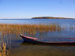
Buffalo Narrows is notable for its scenery and its bridge that crosses the Kisis Channel.[9] The bridge was officially opened in 1981 replacing a ferry. This channel links Peter Pond Lake and Churchill Lake.
Buffalo Narrows Sand Dunes Park
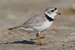
The dunes of Buffalo Narrows Sand Dunes Park located 5 km north of downtown create a 10 km fine sandy beach along the southwest shore of Big Peter Pond Lake (55°53′35.90″N 108°36′39.64″W / 55.8933056°N 108.6110111°W). The park, which is 3,650 hectares (14.1 square miles) in size, includes the peninsula that nearly cuts Peter Pond Lake in two creating Little Peter Pond, the southern section and Big Peter Pond, the northern section. Formerly Crown land, the recreation area was transferred to the Northern Village of Buffalo Narrows in 2003. The community has assumed the responsibility for its maintenance and development.[13][14] The beach is a nesting site of the vulnerable sparrow-sized piping plover.[15]
Transportation
Buffalo Narrows is connected to the rest of Saskatchewan by Highway 155. Highway 155 is paved along its whole length. The community is served by the Buffalo Narrows Airport and the Buffalo Narrows Water Aerodrome. The Saskatchewan Transportation Company offers bus service for passengers and freight. The route goes from La Loche to Prince Albert and back.
Education
The school in Buffalo Narrows is called Twin Lakes Community School or "TLCS". The K-12 school has approximately 310 students and about 30 teachers and is part of the Northern Lights School Division # 113.[15] Northlands College maintains a satellite campus in Buffalo Narrows.
References
- ↑ "Search for Municipal Information". Government of Saskatchewan. Archived from the original on 10 March 2014. Retrieved 7 April 2014.
- ↑ "2011 Community Profiles". Statistics Canada. Government of Canada. Retrieved 30 May 2012.
- ↑ National Archives, Archivia Net. "Post Offices and Postmasters". Archived from the original on 6 October 2006. Retrieved 6 September 2009.
- ↑ Government of Saskatchewan, MRD Home. "Municipal Directory System". Archived from the original on 15 January 2016. Retrieved 6 September 2009.
- ↑ Commissioner of Canada Elections, Chief Electoral Officer of Canada (2005). "Elections Canada On-line". Archived from the original on 21 April 2007. Retrieved 6 September 2009.
- ↑ "Statistics Canada (Community profiles)". Retrieved 12 October 2012.
- ↑ "History of Buffalo Narrows". Retrieved 31 March 2013.
- ↑ John Macoun (1922), Autobiography of John Macoun, M.A (page 121), Ottawa: Ottawa Field-Naturalists' Club, Library of Congress QH31.M15
- 1 2 3 "Geographical Names Query". Retrieved 16 April 2013.
- ↑ "2011 Community Profiles". Canada 2011 Census. Statistics Canada. July 5, 2013. Retrieved 2012-05-30.
- ↑ "2006 Community Profiles". Canada 2006 Census. Statistics Canada. March 30, 2011. Retrieved 2012-05-30.
- ↑ Environment Canada Canadian Climate Normals 1981–2010, accessed 10 November 2016
- ↑ "Government of Saskatchewan (COMMUNITY OF BUFFALO NARROWS WILL BE GETTING NEW RECREATION SITE)". 7 October 2003. Retrieved 2014-02-17.
- ↑ "Buffalo Narrows Assumes Control of Beach Site". 2010-08-01. Retrieved 2014-02-17.
- 1 2 "Northern Lights School Division # 113". Retrieved 2014-07-02.
External links
- Ministry of Northern Affairs
- Map of Buffalo Narrows
- A History of Buffalo Narrows
- Buffalo Narrows Community Profile
 |
| |||
| |
La Ronge | |||
| ||||
| | ||||