Buckhorn Lake (Ontario)
| Buckhorn Lake | |
| Lake | |
| Country | Canada |
|---|---|
| Province | Ontario |
| County | Peterborough |
| Townships | Trent Lakes, Selwyn |
| Part of | Great Lakes Basin |
| Elevation | 245 m (804 ft) |
| Coordinates | 44°29′20″N 78°23′29″W / 44.48889°N 78.39139°WCoordinates: 44°29′20″N 78°23′29″W / 44.48889°N 78.39139°W |
| Mouth | Lower Buckhorn Lake |
| - location | Trent Lakes |
| Length | 14 km (9 mi) |
| Width | 7 km (4 mi) |
 Location of Buckhorn Lake in southern Ontario
| |
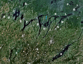 The Kawartha lakes; Buckhorn is H. Click on image for full legend.
| |
Buckhorn Lake is a lake in the townships of Trent Lakes and Selwyn in Peterborough County, Ontario, Canada, and is one of the Kawartha lakes.
The primary inflow is from Pigeon Lake through the Gannon Narrows at the west. Secondary inflows are from Chemong Lake through the Harrington Narrows to Harrington Bay at the south, and from Sandy Lake via Sandy Creek to Sandy Creek Bay at the south. A dam and lock 31 of the Trent–Severn Waterway at the community of Buckhorn control the outflow of the lake to Lower Buckhorn Lake at the northeast.
It appears that the lake acquired its name as a consequence of its shape, appearing similar in shape to a buck's head with antlers or horns projecting either side, being Pigeon and Chemong Lakes.
Settlements on the lake include Buckhorn, the Curve Lake First Nation, Gannon Village, Gannon Beach, Kawartha Hideaway, Kimberley Park, Oak Orchard and Young's Cove.
References
- "Buckhorn Lake". Geographical Names Data Base. Natural Resources Canada. Retrieved 2010-07-11.
- "Toporama - Topographic Map Sheets 31D8, 31D9". Atlas of Canada. Natural Resources Canada. Archived from the original on 2010-08-31. Retrieved 2010-07-11.