Trent Lakes
| Trent Lakes | |
|---|---|
| Township (lower-tier) | |
| Township of Trent Lakes | |
|
Burleigh Falls | |
 Trent Lakes | |
| Coordinates: 44°40′N 78°26′W / 44.667°N 78.433°WCoordinates: 44°40′N 78°26′W / 44.667°N 78.433°W | |
| Country |
|
| Province |
|
| County | Peterborough |
| Incorporated | January 1, 1998 |
| Government | |
| • Type | Township |
| • Mayor | Bev Matthews |
| • Federal riding | Peterborough-Kawartha |
| • Prov. riding | Haliburton—Kawartha Lakes—Brock |
| Area[1] | |
| • Land | 860.26 km2 (332.15 sq mi) |
| Population (2011)[1] | |
| • Total | 5,105 |
| • Density | 5.9/km2 (15/sq mi) |
| Time zone | EST (UTC-5) |
| • Summer (DST) | EDT (UTC-4) |
| Postal Code | K0L |
| Area code(s) | 705 |
| Website |
www.galwaycavendish harvey.ca |
Trent Lakes is a township in the rural, mostly wooded northern section of Peterborough County, Ontario, Canada.
The municipality was formed in 1998 as Galway-Cavendish and Harvey Township through an amalgamation of the township of Galway & Cavendish and the township of Harvey.
On February 19, 2013, the municipal council passed a bylaw to change the name of the township to the Municipality of Trent Lakes.[2]
Communities
The municipality comprises the communities of Buckhorn, Buckhorn Lake Estates, Burleigh Falls, Catchacoma, Crystal Lake, Ewan, Flynns, Fortescue, Kawartha Hideaway, Lakehurst, Mississauga Landing, Mount Irwin, Nogies Creek, Oak Shores Estates, Point Pleasant, Rockcroft and Sugar Bush.
Geography
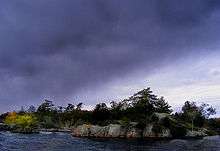
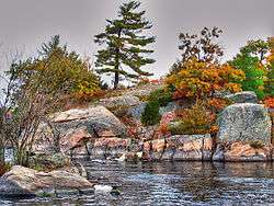
Trent Lakes is home to Kawartha Highlands Provincial Park, which is set around Catchacoma Lake and Mississauga Lake. A 37587.00 ha Natural Environment Park permitting "backcountry" camping and primarily a water access only interior. Three violent summer wind storms have hit this area doing damage to property and forest, one in 1927, then 1995 and in 2006. The area is also a popular cottaging and recreational area.
Trent Lakes consists mostly of Precambrian Shield, dating from 600 to 1200 million years. The granite is normally pink but interlaced with other colours of white and black as one heads north. These areas are primarily "Igneous" granite which was subject to intense heat and pressure during the movement of the Earth's crust. The changes took place as the rock mixed with other elements in the Earth's crust. The mixture is mostly with black and white marble. The region also has sections of Limestone Flats. When the lakes that covered most of Lake Ontario dried up some 450 million years ago the lake sediments hardened and lifted to form a top layer of limestone over the area. With the ice age small glaciers left a thin layer of soil. The area around what is known as Flynn's Turn (intersection of Peterborough County Road 36 and Country Road 507) is a prime example of a limestone flat.
On highway 49 you can see the evidence of what is called a Limestone Ridge ("Ordovician strata". This same ridge extends to Lower Buckhorn Lake and the erosion on the northern edge has created a scarp (or steep cliff) some 30 meters high in areas.
Sandy Lake and the beach area has a unique soft turquoise colour. This is a white "marl" lake bottom and is spring fed. Surrounded by a limestone karst runoff enters into the lake with very little organic material and this contributes to the unique greenish-blue colouration. The marl bottom is extremely soft and rich with minerals.
The community is a scenic location where Paleozoic limestone formations yield to the underlying Precambrian bedrock of pink gneiss; as a result, it attracts a large number of summer residents and visitors.
History
The area is rich in early First Nations sites, and many First Nations members live in the community year-round or seasonally on some of the islands in Lovesick Lake.
The old Harvey fire tower was located at the southern edge of Mississagua Lake (then known as Gull Lake). It was one of the 320 towers in the province used as an early warning in the detection of forest fires. Part of the Lindsay Forest District of towers this tower had its own phone line connection back to headquarters. The phone line still runs through the forest and up the hill to the old towers footings. In 1927 the Harvey tower was made of wood, but a hurricane came through and blew it over. Parts of the tower were found miles away. A newer wood tower was built in its place, that is, until 1938 when a light steel tower was erected. The tower system was abandoned by 1970 when aerial detection became favoured.
Demographics
| Canada census – Trent Lakes community profile | |||
|---|---|---|---|
| 2011 | 2006 | 2001 | |
| Population: | 5105 (-3.4% from 2006) | 5284 (20.9% from 2001) | 4372 (-0.6% from 1996) |
| Land area: | 860.26 km2 (332.15 sq mi) | 848.26 km2 (327.52 sq mi) | 848.21 km2 (327.50 sq mi) |
| Population density: | 5.9/km2 (15/sq mi) | 6.2/km2 (16/sq mi) | 5.2/km2 (13/sq mi) |
| Median age: | 51.7 (M: 52.1, F: 51.4) | 50.5 (M: 50.8, F: 50.2) | |
| Total private dwellings: | 5287 | 5407 | 5005 |
| Median household income: | $49,398 | $41,550 | |
| References: 2011[3] 2006[4] 2001[5] | |||
Mother tongue:[4]
- English as first language: 90.3%
- French as first language: 1.4%
- English and French as first language: 0%
- Other as first language: 8.3%
Population trend:[6]
- Population in 2011: 5105
- Population in 2006: 5284
- Population in 2001: 4372
- Population in 1996:
- Galway and Cavendish (township): 765
- Harvey (township): 3635
- Population in 1991:
- Galway and Cavendish (township): 727
- Harvey (township): 3146
Recreation
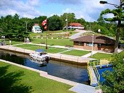
Boaters use the Trent–Severn Waterway lock which raises boats 24 feet (7.3 m) from Stony Lake to Lovesick Lake.[7] Boat campers find the nearby Wolf Island Provincial Park an ideal secluded place to camp, free from the crowds found at road-access parks.[8]
See also
References
- 1 2 "Galway-Cavendish and Harvey census profile". 2011 Census of Population. Statistics Canada. Retrieved 2012-03-09.
- ↑ "Galway-Cavendish and Harvey Township to be renamed Trent Lakes Township". Peterborough Examiner, February 6, 2013.
- ↑ "2011 Community Profiles". Canada 2011 Census. Statistics Canada. July 5, 2013. Retrieved 2012-03-09.
- 1 2 "2006 Community Profiles". Canada 2006 Census. Statistics Canada. March 30, 2011. Retrieved 2012-03-09.
- ↑ "2001 Community Profiles". Canada 2001 Census. Statistics Canada. February 17, 2012. Retrieved 2012-03-09.
- ↑ Statistics Canada: 1996, 2001, 2006 census
- ↑ "Lock 28 - Burleigh Falls". Trent-Severn Waterway National Historic Site of Canada. Parks Canada. Retrieved 2009-05-08.
- ↑ "Wolf Island". Ontario Parks. 2002-11-12. Retrieved 2009-05-08.
External links
 |
Minden Hills | Highlands East | | |
| Kawartha Lakes | |
North Kawartha | ||
| ||||
| | ||||
| Selwyn, Curve Lake 35A, Curve Lake First Nation 35 |