Broad Mountain (Lehigh Valley)
| Broad Mountain[1] | |
|---|---|
|
USGS relief: The "Barrier Wall" of Broad Mountain (center Landform) and the Terrains it dominates west of the Lehigh Gorge and north of Tamaqua, Nesquehoning and Jim Thorpe, PA | |
| Highest point | |
| Peak | Broad Mountain, Carbon County[2] |
| Elevation | 547.116 m (1,795.00 ft) GNIS |
| Coordinates | 40°54′34″N 75°48′24″W / 40.90944°N 75.80667°WCoordinates: 40°54′34″N 75°48′24″W / 40.90944°N 75.80667°W |
| Dimensions | |
| Length | 14–15.0 mi (22.5–24.1 km) east-west |
| Geography | |
 Broad Mountain had a large importance in local Rail Transportation. The Nesquehoning Creek rises steeply along its southern face to traverse the mountain pass occupied by today's Hometown sitting in a saddle between it and Nesquehoning Ridge. Paralleling both to the south across Nesquehoning Creek, are Rt-54, and the RBMN railroad, successor to the Lehigh and Susquehanna Railroad and its leasee, the Central Railroad of New Jersey. Above the North-face, the stream valleys hosted the Beaver Meadows Railroad, later the oldest part of the fabled Lehigh Valley Railroad (Operated today by (Norfolk-Southern). | |
| Country | United States |
| State | Pennsylvania |
| Borders on | Ridge-and-Valley Appalachians, Nesquehoning Creek and Upper Lehigh River at lower Lehigh Gorge |
| Geology | |
| Orogeny | Appalachian Mountains |
| Age of rock | Silurian?? |
| Type of rock | Tuscarora Formation?? and Shawangunk Formation; sedimentary |
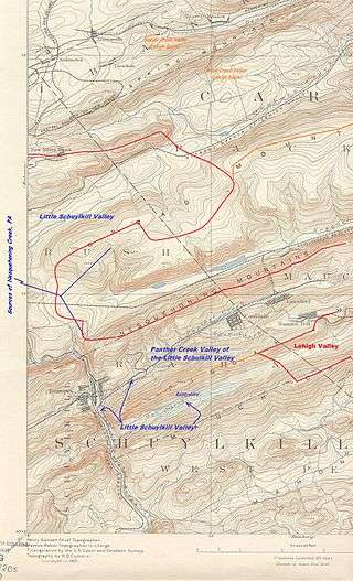
Broad Mountain or Broad Ridge in the Ridge-and-Valley Appalachians in Carbon County and Schuylkill County in Eastern Pennsylvania is a steep faced, anthracite bearing barrier ridge just south of both Beaver Meadows and Weatherly, north of Nesquehoning and west & south of the Lehigh River basin (so the west border of the Poconos). The Mountain ridge line is mostly flat and looks very similar to the man made piles of culm in the region from the roads and towns looking up; being a natural mountain, it is quite different when under ones feet.
The long ridge has several peaks and the WSW peak in Schuylkill County is just 23 feet (7.0 m) short of the summit altitude of the Carbon County peak. The WSW section also continues a important watershed terrain separating the waters of the Schuylkill basin from those of the Lehigh River, which receives the majority of outflow. Broad Ridge and Nesquehoning Ridge are joined together at elevation at the location of Hometown, Pennsylvania through which an important railroad line and PA Route 54 climb from Nesquehoning, nestled into an notch around the ridge's southern face.
Oriented East-West and flanked in its south by Nesquehoning Creek the ridgeline extends 14 miles (23 km)[3] from the right bank of the Lehigh Gorge to the left bank of the Little Schuylkill River near the railroad junctions at Hometown, PA and Delano, PA.
See also
References
- [ USGS GNIS System Broad Mountain Pennsylvania]
Footnotes
- ↑ "Broad Mountain". Geographic Names Information System. United States Geological Survey. Retrieved 2016-05-04., 2ndary Schuylkill County summit by 23 ft. to id# 1212038 & tower #1212363
- ↑ "Broad Mountain + Tower, Carbon County". Geographic Names Information System. United States Geological Survey. Retrieved 2016-09-09. Summary data: Broad Mountain, 1212038, Summit, Carbon, PA, 405435N, 0754824W, 1795, Weatherly, -, 30-AUG-1990
- ↑ Approximate, parallel and similar distance as Jim Thorpe to Tamaqua cited in Lehigh Coal and Navigation Company
External links
- TBDL