Brent Knoll Camp
| Brent Knoll Camp | |
|---|---|
 | |
| Location | Brent Knoll, Somerset, England |
| Coordinates | 51°15′15″N 2°56′44″W / 51.25417°N 2.94556°WCoordinates: 51°15′15″N 2°56′44″W / 51.25417°N 2.94556°W |
| Area | 1.6 hectares (16,000 m2) |
| Built | Iron Age |
| Official name: Brent Knoll hill fort | |
| Designated | 3 June 1994[1] |
| Reference no. | 24001 |
 Location of Brent Knoll Camp in Somerset | |
Brent Knoll Camp is an Iron Age Hill fort at Brent Knoll, 3 kilometres (1.9 mi) from Burnham-on-Sea, Somerset, England. It has been designated as a Scheduled Ancient Monument (No: 24001),[1] and is now in the care of the National Trust.
The hill is 137 metres (449 ft) high[2] dominates the low surrounding landscape of the Somerset Levels and is visible from the M5 motorway.
Name
The word 'knoll' usually means a small hill or hill-top. The origin of the name Brent is unclear, but one possibility is from a word meaning burnt in Old English, suggesting that the settlement was at some time burnt by the Danes.[3] Another proposal is that the name comes from a Celtic term meaning "high place",[1] or even from another Celtic word, briant, meaning law, as the law was anciently promulgated from high places. Another possibility is that the name of Brent simply derives from the local river, the Brent, which gives its name to a Somerset hundred.[3][4]
Brent Knoll Hill
The hill consists of clays and limestone from the Jurassic era and geologically forms an outcrop of the nearby Mendip Hills.[5]
Before the Somerset Levels were drained, Brent Knoll was an island, known as the Isle (or Mount) of Frogs, that provided a safe haven from the water and marshes.[6] It temporarily became an island again during the Bristol Channel floods of 1607.
There is a small reservoir on the south east flank of the knoll.
History
Background
Hill forts developed in the Late Bronze and Early Iron Age, roughly the start of the first millennium BC.[7] The reason for their emergence in Britain, and their purpose, has been a subject of debate. It has been argued that they could have been military sites constructed in response to invasion from continental Europe, sites built by invaders, or a military reaction to social tensions caused by an increasing population and consequent pressure on agriculture. The dominant view since the 1960s has been that the increasing use of iron led to social changes in Britain. Deposits of iron ore were located in different places to the tin and copper ore necessary to make bronze, and as a result trading patterns shifted and the old elites lost their economic and social status. Power passed into the hands of a new group of people.[8] Archaeologist Barry Cunliffe believes that population increase still played a role and has stated "[the forts] provided defensive possibilities for the community at those times when the stress [of an increasing population] burst out into open warfare. But I wouldn't see them as having been built because there was a state of war. They would be functional as defensive strongholds when there were tensions and undoubtedly some of them were attacked and destroyed, but this was not the only, or even the most significant, factor in their construction".[9]
Bronze and Iron Ages

Brent Knoll has seen human settlement since at least the Bronze Age, becoming an Iron Age Fort about 2,000BC,[2] which covers an area of 1.6 hectares (16,000 m2). It is defended by a single wall around 10 metres (33 ft) high and by a single ditch, with an entrance on the eastern side,[10] with a second bank on the north east side.[1] It is surrounded by multiple ramparts (multivallate) following the contours of the hill, however these have been heavily damaged by cattle and quarrying.[10]
Roman
The Romans used its summit as a fortification. An urn containing coins of the Roman Emperors Trajan and Severus was found at the site before 1790. Other finds have included pennant sandstone roof tiles and painted wall plaster, indicative of a substantial building that is more likely to have been a temple than a villa. Many of the finds are in the Somerset County and Weston-super-Mare Museums, with Romano-British pottery in the Blake Museum, Bridgwater.[1]
Anglo-Saxon
The fort has been claimed as the site of Mons Badonicus.[11] This was a battle between a force of Britons and an Anglo-Saxon army, probably sometime between 490 and 517 AD.[12] Though it is believed to have been a major political and military event, there is no certainty about its date or place.
It is also believed to be the site of a battle in 875 at which forces of the Anglo-Saxon kingdom of Wessex drove away the Great Heathen Army led by Guthrum,[5] prior to the Treaty of Wedmore, which was signed three years later.
Medieval

During the medieval era the local land was held by Glastonbury Abbey until the dissolution of the monasteries in 1536.[2]
Around the sides and top of the hill are several scarps which may be medieval strip lynchets.[1][13]
Modern era
Limestone was quarried from the knoll, possibly during the 19th century but the exact date is unknown.[14]
During World War II it was the site of a gun emplacement manned by the Home Guard.[2] The remains of slit trenches with angle-iron stakes can still be seen on the western and south-western sides.[15]
In 1979 the freehold of 13.285 hectares (32.83 acres) was acquired by the National Trust from R P P Johnston.[16]
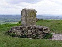
The stone marker on the hill, which also serves as a Triangulation station, commemorates the golden jubilee of Queen Victoria.[17]
In 2006 a resistivity survey was undertaken at the northern end of the hill fort. It showed several linear features that might be structures.[18]
Legend
According to legend, Ider son of Nuth, who was one of King Arthur's knights, came to the Mount of Frogs on a quest to slay three giants who lived there.[19][20][21][22]
See also
References
- 1 2 3 4 5 6 "Brent Knoll hillfort, Brent Knoll". Somerset Historic Environment Record. South West Heritage Trust. Retrieved 19 January 2011.
- 1 2 3 4 "Brent Knoll village web site". Brent Knoll village web site. Retrieved 19 January 2011.
- 1 2 Sylvanus Urban, ed., The Gentleman's Magazine (1846), p. 359: "The derivation from burning is not so extravagant, for such, we believe, is the authentic etymology of Brentwood, in Essex".
- ↑ Benjamin Clarke, The British gazetteer, political, commercial, ecclesiastical (1852), p. 405: "The name is evidently derived from its being situated on the banks of the river Brent..."
- 1 2 "A Brief History of Brent Knoll Village". Brent Knoll Village. Retrieved 8 November 2016.
- ↑ "Brent Knoll (Sacred sites around Glastonbury)". Isle of Avalon. Retrieved 19 January 2011.
- ↑ Payne, Andrew; Corney, Mark; Cunliffe, Barry (2007), The Wessex Hillforts Project: Extensive Survey of Hillfort Interiors in Central Southern England, English Heritage, p. 1, ISBN 978-1-873592-85-4
- ↑ Sharples, Niall M (1991), English Heritage Book of Maiden Castle, London: B. T. Batsford, pp. 71–72, ISBN 0-7134-6083-0
- ↑ Time Team: Swords, skulls and strongholds, Channel 4, 2008-05-19, retrieved 16 September 2009
- 1 2 Adkins, Lesley and Roy (1992). A field Guide to Somerset Archeology. Stanbridge: Dovecote press. pp. 29–30. ISBN 0-946159-94-7.
- ↑ "Brent Knoll Hillfort.". Digital Digging. Retrieved 19 January 2011.
- ↑ Ashe, Geoffrey, From Caesar to Arthur pp.295-8
- ↑ "Strip lynchets and field system, Brent Knoll". Somerset Historic Environment Record. South West Heritage Trust. Retrieved 20 January 2011.
- ↑ "Quarries, Brent Knoll". Somerset Historic Environment Record. South West Heritage Trust. Retrieved 20 January 2011.
- ↑ "Slit trenches, Brent Knoll". Somerset Historic Environment Record. South West Heritage Trust. Retrieved 20 January 2011.
- ↑ "National Trust Acquisition Data" (PDF). National Trust. Archived from the original (PDF) on 29 June 2011. Retrieved 19 January 2011.
- ↑ Kramer, Tracy. "Somerset's Finest Hill Forts". Time Travel Britain. Retrieved 20 January 2011.
- ↑ "Geophysical survey (2006), Brent Knoll hillfort". Somerset Historic Environment Survey. South West Heritage Trust. Retrieved 20 January 2011.
- ↑ "Brent Knoll (Hillfort)". The Modern Antiquarian. Retrieved 19 January 2011.
- ↑ "A guide to Somerset's mysterious sites". Mysterious Britain Gazetteer. Retrieved 19 January 2011.
- ↑ "A gazetteer of Arthurian sites". Southern Methodist University. Archived from the original on 3 April 2007. Retrieved 19 January 2011.
- ↑ "Brent Knoll". Arthurian Adventure. Retrieved 20 January 2011.