Branchville, Georgia
| Branchville, Georgia Branchville Community | |
|---|---|
| Unincorporated community | |
| Country | United States |
| State | Georgia |
| County | Mitchell |
| Area | |
| • Total | 98.5 sq mi (255 km2) |
| Elevation | 140 ft (40 m) |
| Population (2007) | |
| • Total | 1,090 |
| • Density | 11/sq mi (4/km2) |
| Time zone | Eastern (EST) (UTC-5) |
| • Summer (DST) | EDT (UTC-4) |
| Area code(s) | 229 |
Branchville is an unincorporated community located in Mitchell County, Georgia, United States.
Geography
Branchville has a latitude at 31.15 and a longitude at -84.315. It is found on the Branchville U.S. Geological Survey Map. The only lake in the community is Gee Pond. Big Slough and Bay Pole Branch are the only flowing streams. It is located on Georgia Highway 65 at the intersection of Branchville Road. Forest Road, Sassafras Tea Road, Stillwater Road, Gee Pond Road, Branchville Church Road, and Long Leaf Road are roads that run through the area.[1]
Demographics
As of 2007 there were 535 males and 555 females. The resident median age is 38 years. Racial make up consists of 71.1% Whites, 25.1% Blacks, 1.5% Hispanics, 1.0% Persons of mixed Race, .04% Asian, and 0.3% American. 21 Residents were not born in the U.S. 9.7% of persons are unemployed. Homosexual households consist of 0.0% Lesbian households and 0.5% Gay households. The average household size is 2.6 people with 57.7% belonging to a family and 4.1% to unmarried persons. Residents below the poverty level as of 2009 are at 22.6%. The median household income is below state average while the median house value is far below average state value. Percentage of college students is far below state average as well as the percent of persons with a bachelor's degree or higher. The predominate political party is Republican. Religious affiliations consist of 74.0% Southern Baptist, 13.1% United Methodist, 4.3% Assembly of God, 3.9% Free Will Baptist, 1.0% Church of God, 0.7% Presbyterian, 0.6% Catholic, 0.6% Primitive Baptist, 0.6% Church of Christ, and 1.2% Other.[2]
External links
- http://vanishingsouthgeorgia.com/ Photo Credit
- ↑ "Branchville, Georgia GA Community". Georgia Hometown Locator. Retrieved 2011-05-07.
- ↑ "Mitchell County, Georgia detail". City Data.com. Retrieved 2011-05-07.
Municipalities and communities of Mitchell County, Georgia, United States | ||
|---|---|---|
| Cities | 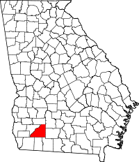 | |
| Town | ||
| Unincorporated communities | ||
| Footnotes | ‡This populated place also has portions in an adjacent county or counties | |
Coordinates: 31°09′02″N 84°18′56″W / 31.15056°N 84.31556°W