Braeburn Lodge
Braeburn Lodge
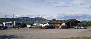
Braeburn Lodge is a roadhouse on the Klondike Highway in the Yukon Territory of Canada. It is located east of Braeburn Lake and north of Braeburn Mountain, on the path of the former Dawson Overland Trail, which was built in 1902 between Whitehorse and Dawson City.[1] The lodge itself is a tourist destination and is famous for its large cinnamon buns.[2] Nearby Cinnamon Bun Airport is named for the lodge's cinnamon buns.[3] Every February, Braeburn Lodge hosts a checkpoint of the long-distance Yukon Quest sled dog race.
Climate
| Climate data for Braeburn (1981–2010) 61°28′01″N 135°46′59″W / 61.46694°N 135.78306°W | |||||||||||||
|---|---|---|---|---|---|---|---|---|---|---|---|---|---|
| Month | Jan | Feb | Mar | Apr | May | Jun | Jul | Aug | Sep | Oct | Nov | Dec | Year |
| Record high °C (°F) | 9.0 (48.2) |
7.8 (46) |
13.5 (56.3) |
21.5 (70.7) |
34.0 (93.2) |
30.5 (86.9) |
30.5 (86.9) |
31.5 (88.7) |
26.0 (78.8) |
18.5 (65.3) |
8.9 (48) |
10.0 (50) |
34.0 (93.2) |
| Average high °C (°F) | −14.4 (6.1) |
−10.7 (12.7) |
−0.9 (30.4) |
7.4 (45.3) |
14.2 (57.6) |
19.1 (66.4) |
21.1 (70) |
19.0 (66.2) |
12.4 (54.3) |
2.7 (36.9) |
−10.2 (13.6) |
−13.7 (7.3) |
3.8 (38.8) |
| Daily mean °C (°F) | −20.7 (−5.3) |
−18.4 (−1.1) |
−9.4 (15.1) |
0.3 (32.5) |
6.9 (44.4) |
11.3 (52.3) |
13.8 (56.8) |
11.3 (52.3) |
5.8 (42.4) |
−2.3 (27.9) |
−16.0 (3.2) |
−19.9 (−3.8) |
−3.1 (26.4) |
| Average low °C (°F) | −27.0 (−16.6) |
−26.0 (−14.8) |
−17.9 (−0.2) |
−6.9 (19.6) |
−0.5 (31.1) |
3.5 (38.3) |
6.4 (43.5) |
3.6 (38.5) |
−0.8 (30.6) |
−7.3 (18.9) |
−21.8 (−7.2) |
−26.1 (−15) |
−10.1 (13.8) |
| Record low °C (°F) | −55.0 (−67) |
−54.0 (−65.2) |
−46.5 (−51.7) |
−31.5 (−24.7) |
−10.0 (14) |
−5.0 (23) |
−1.5 (29.3) |
−6.0 (21.2) |
−19.0 (−2.2) |
−38.0 (−36.4) |
−54.0 (−65.2) |
−53.5 (−64.3) |
−55.0 (−67) |
| Average precipitation mm (inches) | 15.3 (0.602) |
15.1 (0.594) |
6.9 (0.272) |
5.3 (0.209) |
23.3 (0.917) |
38.8 (1.528) |
62.9 (2.476) |
33.4 (1.315) |
31.3 (1.232) |
22.1 (0.87) |
19.9 (0.783) |
17.2 (0.677) |
291.4 (11.472) |
| Average rainfall mm (inches) | 0.0 (0) |
0.0 (0) |
0.0 (0) |
2.4 (0.094) |
22.6 (0.89) |
38.8 (1.528) |
62.9 (2.476) |
33.1 (1.303) |
27.3 (1.075) |
8.0 (0.315) |
0.0 (0) |
0.1 (0.004) |
195.2 (7.685) |
| Average snowfall cm (inches) | 15.3 (6.02) |
15.1 (5.94) |
6.9 (2.72) |
3.0 (1.18) |
0.7 (0.28) |
0.0 (0) |
0.0 (0) |
0.3 (0.12) |
4.0 (1.57) |
14.1 (5.55) |
19.9 (7.83) |
17.0 (6.69) |
96.2 (37.87) |
| Average precipitation days (≥ 0.2 mm) | 6.1 | 6.7 | 3.9 | 2.7 | 9.1 | 10.7 | 15.5 | 11.0 | 10.6 | 8.5 | 8.4 | 6.5 | 99.5 |
| Average rainy days | 0.0 | 0.0 | 0.0 | 1.4 | 8.8 | 10.7 | 15.5 | 10.9 | 9.8 | 3.0 | 0.0 | 0.1 | 60.2 |
| Average snowy days (≥ 0.2 cm) | 6.1 | 6.7 | 3.9 | 1.3 | 0.3 | 0.0 | 0.0 | 0.2 | 1.4 | 5.6 | 8.4 | 6.5 | 40.3 |
| Source: Environment Canada Canadian Climate Normals 1981–2010[4] | |||||||||||||
References
- ↑ Klondike Snowmobile Association. "Dawson Overland Trail", ksa.yk.ca. Accessed February 15, 2009. Archived March 12, 2008, at the Wayback Machine.
- ↑ Yukon College. "Braeburn", dl1.yukoncollege.yk.ca. Accessed April 15, 2009. Archived July 6, 2011, at the Wayback Machine.
- ↑ Karo Enterprises. "Braeburn Lodge", Karo-ent.com. Accessed April 15, 2009. Archived September 8, 2008, at the Wayback Machine.
- ↑ "Braeburn" (CSV (2874 KB)). Canadian Climate Normals 1981–2010. Environment Canada. Climate ID: 2100167. Retrieved 2016-03-20.
| Regions | |
|---|---|
| Municipalities | |
| Communities | |
| Ghost towns | |
| Parks | |
| |
Coordinates: 61°29′04″N 135°46′35″W / 61.48444°N 135.77639°W
This article is issued from Wikipedia - version of the 11/14/2016. The text is available under the Creative Commons Attribution/Share Alike but additional terms may apply for the media files.