Borroloola
| Borroloola Northern Territory | |||||||
|---|---|---|---|---|---|---|---|
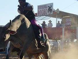 The Borroloola rodeo is held in August each year | |||||||
|
Borroloola | |||||||
| Coordinates | 16°04′13″S 136°18′26″E / 16.07028°S 136.30722°ECoordinates: 16°04′13″S 136°18′26″E / 16.07028°S 136.30722°E | ||||||
| Population | 926 (2011 census)[1] | ||||||
| Postcode(s) | 0854 | ||||||
| Elevation | 17 m (56 ft) | ||||||
| Location |
| ||||||
| LGA(s) | Roper Gulf Region | ||||||
| Territory electorate(s) | Barkly | ||||||
| Federal Division(s) | Lingiari | ||||||
| |||||||
Borroloola is a town in the Northern Territory of Australia. It is located on the McArthur River, about 50 km upstream from the Gulf of Carpentaria. At the 2011 census, Borroloola had a population of 926.[1]
Location
Borroloola lies on the traditional country of the Yanyuwa people, on the coastal plain between the Barkly Tablelands and the Gulf of Carpentaria. Rivers that run from the Tablelands escarpment to the Gulf regularly flood in the wet season, making travel on the unsealed section of Highway One along the coastal plain to Queensland impossible. The rivers of this region have carved spectacular gorges through sandstone deposits in their upper reaches. The rivers and coastal areas are host to barramundi, earning Borroloola a reputation among sports fisherman, and also to the deadly saltwater crocodile. The region has little rain from May to September, and is characterised by lightly treed Savanna grasslands.
History
The 'Coast Track' follows the path of cattle drovers of the late 19th century as they moved herds from north-west Queensland to stock the new stations of the Northern Territory and the Kimberley. The drovers in turn followed a well-worn Aboriginal path. Tony Roberts (2005) writes a moving and well-researched history of the region, in which the local tribes went from almost total isolation from European Australians in 1870, to a decimated collection of displaced and defeated groups, over a single decade. Entire tribes such as the Wilangarra, including women, children and babies were massacred, and most adult males were killed, by police and quasi-police groups, and by drovers and station workers involved in the cattle droves of that era.
In the local Indigenous languages of Yanyuwa, Garrwa, Marra, Gudanji and Binbingka, Borroloola would be written as Burrulula. The name belongs to a small lagoon just to the east of the present day caravan park. The name originally Borrolooloo, translates borrow women, name of the lagoon and associated with the Hill Kangaroo. It was at this site that the Hill Kangaroo Ancestral Being (Nangurrbuwala) danced his ceremonies. The white barked gum trees in the area are said to be his body decorations as they flew from his body as he danced. Other Indigenous names in the area of Borroloola are Wurrarawala (Trig Hill) this hill is associated with the backbone of the Hill Kangaroo Ancestor. Bunubunu (Rocky Creek), this creek is associated with a File Snake Ancestor. Warralungku (The McArthur River Crossing) and Mabunji, a set of specific rocks at the McArthur River Crossing that carry the imprint of the Hill Kangaroo's tail and feet. The area of Borroloola belongs to members of the Rrumburriya clan. (see also "Forget About Flinders" A Yanyuwa Atlas of the south west Gulf of Carpentaria (2002) by Yanyuwa families, John Bradley and Nona Cameron. J.M. McGregor Publishers. Queensland)
The community
The King Ash Bay fishing club is situated on the McArthur River about 40 km downstream (north-east) from Borroloola by river, just over 40 km from Borroloola by road. Their boat ramp provides access to the mangrove-lined waterways of the McArthur estuary and the Sir Edward Pellew Group of Islands in the Gulf of Carpentaria. The largely self-contained village houses a small permanent population during the wet season, but numbers swell as tourists, mostly retired and semi-retired, arrive in April and May to enjoy the mild dry season weather. The Fishing Classic competition, held over the Easter weekend each year (weather and road access permitting), marks the end of the wet season.
The Borroloola Community Education Centre (CEC) contains a preschool, primary school and secondary school. The Borroloola CEC has a combined staff of more than 25. The staff are composed of mostly out-of-state teachers and local indigenous teacher aides. The CEC enjoys an average attendance of 100 students, but has far more listed on its rolls. Two of the problems facing the school are intermittent student attendance and a high staff turnover. The current Principal is Geoff Perry, who took over the school in 2008.
The CEC has seen much recent construction. In 2007 a 2m tall metal fence was constructed around the preschool and primary school. In 2008 construction began on several new buildings. After the removal of older buildings the new construction will enlarge the school by three buildings.
Health
Borroloola town has a remote clinic and Pharmacy located in the centre of the town.
Borroloola Airport
The Borroloola Airport is 1149 metres long at an elevation of 55 feet (16.8 metres). The airport can be very busy during the day and the occasional Careflight services the town during the night. One single engine Cessna 210 aircraft from Katherine Aviation is based at the airport permanently. It frequently services the region with chartered and government flights to towns and communities such as Robinson River, McArthur River Mine and Katherine, as well as offering scenic flights to the nearby Sir Edward Pellew Islands and surrounding attractions. There are refuelling services for both Avgas and Avtur at the airport and limited parking areas. The runway is lit up at night by solar powered lights.
Climate
Borroloola has a tropical savanna climate with the 3 distinct seasons of the Northern Territory, the wet season, the dry season and the build-up season. Extreme temperatures have ranged from 43.9 °C (111.0 °F) to 0.4 °C (32.7 °F)
| Climate data for Borroloola | |||||||||||||
|---|---|---|---|---|---|---|---|---|---|---|---|---|---|
| Month | Jan | Feb | Mar | Apr | May | Jun | Jul | Aug | Sep | Oct | Nov | Dec | Year |
| Record high °C (°F) | 42.3 (108.1) |
42.7 (108.9) |
38.8 (101.8) |
38.8 (101.8) |
40.3 (104.5) |
35.3 (95.5) |
36.1 (97) |
37.3 (99.1) |
40.5 (104.9) |
43.0 (109.4) |
43.9 (111) |
43.3 (109.9) |
43.9 (111) |
| Average high °C (°F) | 34.2 (93.6) |
33.9 (93) |
33.3 (91.9) |
33.7 (92.7) |
32.2 (90) |
30.0 (86) |
30.1 (86.2) |
31.9 (89.4) |
34.9 (94.8) |
36.6 (97.9) |
37.2 (99) |
36.3 (97.3) |
33.7 (92.7) |
| Average low °C (°F) | 24.8 (76.6) |
24.6 (76.3) |
23.3 (73.9) |
20.2 (68.4) |
15.6 (60.1) |
12.6 (54.7) |
11.9 (53.4) |
13.7 (56.7) |
17.7 (63.9) |
21.5 (70.7) |
23.8 (74.8) |
25.2 (77.4) |
19.6 (67.3) |
| Record low °C (°F) | 19.1 (66.4) |
19.2 (66.6) |
14.9 (58.8) |
9.0 (48.2) |
5.4 (41.7) |
2.7 (36.9) |
0.4 (32.7) |
5.1 (41.2) |
7.8 (46) |
13.3 (55.9) |
13.2 (55.8) |
18.3 (64.9) |
0.4 (32.7) |
| Average rainfall mm (inches) | 192.8 (7.591) |
213.1 (8.39) |
180.1 (7.091) |
75.9 (2.988) |
4.7 (0.185) |
2.2 (0.087) |
0.5 (0.02) |
0.7 (0.028) |
2.4 (0.094) |
15.7 (0.618) |
77.2 (3.039) |
143.9 (5.665) |
946.0 (37.244) |
| Average rainy days | 14.2 | 13.6 | 13.6 | 5.4 | 1.4 | 1.4 | 1.4 | 1.3 | 0.4 | 1.9 | 5.9 | 11.2 | 71.6 |
| Source: [2] | |||||||||||||
The McArthur River Mine
The McArthur River Mine (MRM), owned by Swiss mining giant Xstrata, did not begin as an open-cut mine. Opening in 1995 as an underground zinc and lead mine it already had a controversial history, but it wasn’t until 2006 that major controversies began. In 2006, MRM proposed its expansion to open-cut involving diverting 5.5 km of the McArthur River, a major tropical river. The controversy was not just because this proposal was approved but because of how it was. The decision was pushed through as a matter of urgency, then revoked by action taken by Traditional Owners and environmental groups through the Supreme court. This decision was overturned within days and the mine given the go-ahead once more by parliamentary vote. Again the Traditional Owners took action, taking matters to the Federal court and winning, only to have this decision declared invalid. Finally Peter Garrett, the Environmental Minister, approved the mine through the Federal Court.
Initial approval in 2006 was urged by the current PM, John Howard, who said that "it's in the interests of the nation that this expansion be allowed" and dismissed environmental reproaches by stating that "there are some environmentalists who just don't believe in any mining no matter what". However, the application was denied by Environment Minister, Marion Scrymgour. After Scrymgour’s rejection the case was taken to Mines Minister at the time, Chris Natt. Natt, a former football administrator who was sworn in one month before making the decision, said it was important for the mine and the NT economy to go ahead. This is even though subsequently the mine had not paid a single cent in royalties due to the fact that it had made no profit and was ‘uneconomic’. Still he approved it. This enraged Traditional Owners and environmental groups who responded in April 2007 by appealing to the Supreme Court.
The Northern Land Council (NLC), supported by Traditional Owners and the Environmental Defenders Office, won their case in the Supreme Court and approval for the mine was revoked. The NLC had argued that "the open cut expansion was effectively a new mine and an amended mining management plan for their existing underground operation wasn’t sufficient" and the judge ruled "that the mines minister had acted beyond his powers when he approved the amendment." To this Natt responded by stating this was just a technicality and they would work at rectifying the decision. Within days parliament voted to overrule the decision of the Supreme Court and return permission to the mine. Malarndirri McCarthy, Labor’s member for Arnhem, described this action as an "absolute disgrace" and that "to pass this legislation on urgency, in the middle of sorry business, is the lowest sign of respect for Traditional Owners."
In June 2007 Traditional Owners took their challenge to Federal Court only to have their challenge dismissed. They immediately appealed again and in December the full court of the Federal Court found in their favour. This decision was later declared invalid due to official documents, being the Northern Territory Government's mining management plan, not being present during the decision. The process needed to be redone. By this stage MRM’s new channel was already ready to begin diversion, it was forced to halt until final decision was made. This final decision was left to Federal Environment Minister Peter Garrett. Garrett was responsible for reviewing all material relating to the mine starting back from 2006.
On 14 January 2009, Garrett went to Borroloola to listen to concerns from traditional owners:
Traditional Owner: The company never even talked to us. Because they said they got the power to override Aboriginal people the way they was carrying on.
Leonard Norman, Aboriginal community: We are not against the mines, we've got people who are working there from here, but this is where the breakdown is, there's no consultation. With the Aboriginal people, who are going to be affected.
In response to the court’s decision Xstrata threatened to sack 300 staff on Australia Day unless Garrett made a decision. Garrett declared on 22 January 2009 that "he would approve the expansion of the mine, subject to a further 10 days of evaluation by indigenous groups and others". After this time he approved the expansion promising to do his best to protect the environment including native sawfish and migratory birds.
Australian Conservation Foundation spokesman Justin McCaul: "The message to other mining companies is clear. If you override the wishes of Traditional Owners and engage in environmentally high-impact mining, you will be rewarded with fast-tracked Federal approval. "You cannot move five kilometres of the natural course of a major river because it happens to be in the way of your open-cut mine without posing an unacceptable risk to migratory birds, turtles, dugongs, seagrass meadows and the threatened freshwater sawfish."
References (chronological) Mine Web, ‘Xstrata will get approval for controversial McArthur River mine expansion’, International Business Times, 22 Jan 2009. Peter Ker, ‘Garrett backs controversial mine’, The Age, 23 Jan 2009. Anthony Young, ‘Jealous for Our Country’, 21 July 2009. Independent Monitor, ‘McArthur River Mine Community Report’, Environmental Earth Sciences, 18 Dec 2011. Paddy Manning, ‘Xstrata digs deep for prized zinc deposits’, Sydney Morning Herald, 11 Aug 2012.
Australian Broadcasting Commission (ABC) Investigative Program for TV & Online Melinda James, ‘McArthur River Mine’ (transcript), Stateline, 6 Oct 2006. Melinda James, ‘McArthur River Mine’ (transcript), Stateline, 4 May 2007. Murray Mclaughlin, ‘Garrett flies in to NT to sort out mining dilemma’ (transcript), The 7:30 Report, 15 Jan 2009.
ABC Online News Reports (chronological): Emma Masters, ‘Damning report card for McArthur River Mine’, 12 Nov 2009. Jane Bardon, ‘Mining giant accused of ‘rude’ behaviour’, 15 Mar 2011. Liz Trevaskis, ‘Environmental Concerns for McArthur River Mine’, ABC Rural, 7 Dec 2011.
See also
References
- 1 2 Australian Bureau of Statistics (31 October 2012). "Borroloola (L) (Urban Centre/Locality)". 2011 Census QuickStats. Retrieved 1 December 2013.
- ↑ "Borroloola". Climate statistics for Australian locations. Bureau of Meteorology. Retrieved 13 April 2013.
External links
Good historical background on Borroloola at *walkabout.com.au
- Borroloola Guest House
- King Ash Bay Fishing Club
- Borroloola Pharmacy
- Frontier Justice: A History of the Gulf Country to 1900 Tony Roberts, (Brisbane: UQP 2005)