Borders Abbeys Way

The Borders Abbeys Way is a long-distance footpath in the Scottish Borders area of Scotland. It is a circular walkway and is 64.5 miles (103 km) long.
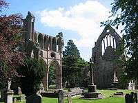
The theme of the footpath is the ruined Borders abbeys (established by David I of Scotland) along its way—Kelso Abbey, Jedburgh Abbey, Melrose Abbey and Dryburgh Abbey—and it also includes the towns of Hawick and Selkirk. The Abbeys were homes to the monks who lived there between the 12th and 16th centuries.
Sections of the Walk
Most people choose to do the Walk in one day for each segment.[1]
| Section | Distance Miles/KM | Start & End Elevation | Highest points |
|---|---|---|---|
| Kelso-Jedburgh | 12/19 | 134 & 280 ft | 390 ft |
| Jedburgh-Hawick | 12.5/20 | 280 & 344 ft | 985 & 563 ft |
| Hawick-Selkirk | 12.5/20 | 344 & 564 ft | 999 & 1113 ft |
| Selkirk-Melrose | 10/16 | 564 & 320 ft | 880 ft |
| Melrose-Kelso | 17.5/28 | 320 & 134 ft | 485 ft |
| Complete walk | 64.5/103 | 1113 ft |
It is divided into five sections, each roughly a days walk.
- Kelso (55°35′49″N 2°25′58″W / 55.5970°N 2.4327°W) to Jedburgh (55°28′36″N 2°33′15″W / 55.4766°N 2.5541°W)
- Jedburgh to Hawick (55°25′43″N 2°47′00″W / 55.4285°N 2.7833°W)
- Hawick to Selkirk (55°32′50″N 2°50′29″W / 55.5471°N 2.8415°W)
- Selkirk to Melrose (55°35′56″N 2°43′09″W / 55.5990°N 2.7191°W)
- Melrose to Kelso
Along the Borders Abbeys Way there are several rivers: Jed Water, River Teviot, River Tweed, Ale Water, and Rule Water.
See also
- Clintmains
- List of places in the Scottish Borders
- List of places in Scotland
- Pennine Way National Trail
- James Hutton Trail
- Roman Heritage Way
- Sir Walter Scott Way
- Southern Upland Way
- St. Cuthbert's Way
References
- ↑ "Abbeys Walk". The Borders Abbeys Way. Scotland's Great Trails.
Sources
- Scottish Borders Council website: Borders Abbeys Way
- Borders Abbeys Way route description and map (Walkhighlands).
- Visit Scotland: Walking the Borders Abbeys Way
- Borders Abbeys Way website
- Scottish Youth Hostels Association: Broadmeadows Hostel
- Scottish Youth Hostels Association: Melrose Hostel
- The Long Distance Walkers Association: Borders Abbeys Way
- Walking Magazine: "Borders of History"
- Britain: "Break for the Borders" Also mention of the Tironsian Abbey in Selkirk
Coordinates: 55°34′41″N 2°34′11″W / 55.5781°N 2.5697°W