Black Butte (Madison County, Montana)
| Black Butte | |
|---|---|
| Pyroxene Butte | |
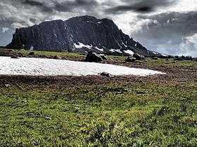 Southeast face Black Butte | |
| Highest point | |
| Elevation | 10,542 feet (3,213 m)[1] |
| Prominence | 3,182 feet (970 m)[1] |
| Coordinates | 44°54′16″N 111°51′18″W / 44.90444°N 111.85500°WCoordinates: 44°54′16″N 111°51′18″W / 44.90444°N 111.85500°W[2] |
| Geography | |
| Location | Madison County, Montana |
| Parent range | Gravelly Range |
| Topo map | Big Horn Mountain |
Black Butte, el. 10,542 feet (3,213 m) is the highest peak in the Gravelly Range in Madison County, Montana. The eastern base of the peak is less than 1 mile (1.6 km) from the Beaverhead-Deerlodge National Forest road #290 (Gravelly Range Road).
See also
Notes
- 1 2 "Black Butte, Montana". Peakbagger.com. Retrieved 2013-07-09.
- ↑ "Black Butte". Geographic Names Information System. United States Geological Survey.
This article is issued from Wikipedia - version of the 12/23/2015. The text is available under the Creative Commons Attribution/Share Alike but additional terms may apply for the media files.