Bike paths in Sydney

Bike paths in Sydney, New South Wales, Australia, vary widely, with the majority either shared cycle and pedestrian paths or on road paths;[1][2] and a small number of separated cycleways. In 2009 the Sydney Morning Herald reported that "Sydney's cycleways are not so much an organised network as a fragmented collection of winding paths and half-finished ideas. Most were built or designed when cycling was viewed as a pleasant pastime rather than a practical form of travel and are now poorly suited to commuting."[3]
In 2013 4,400 cyclists rode to or from Sydney central business district on an average day, via the Sydney Harbour Bridge (2,000), Anzac Bridge (1,400) and Anzac Parade (1,000) cycleways.[4]
See this section for web based maps
Bike paths along freeways and tollways
A number of freeways and tollways have been constructed with dedicated separate bicycle paths built alongside.
M2 Cycleway
Cyclists are poorly served by the M2 Hills Motorway, which runs between North Ryde and Seven Hills. The M2 does not have a separate cycle lane or path. Instead cyclists are expected to use the breakdown lane. Cyclist access was removed in 2010 during construction work on the M2 upgrade. During that time, cyclists were required to use an alternate route on suburban streets that was 5 km longer, steeper & slower.[5] The design of the alternative route was criticised due to safety concerns.[6]
In August 2013 access was restored westbound from Delhi Road to Windsor Road. Citybound access was restored only for the section from Windsor Road to Pennant Hills Road due to work to stabilise the embankment near the eastbound lanes at Marsfield. This work is expected to take until September 2015 and during that time cyclists are unable to access the M2 city bound between Pennant Hills Road and Christie Road.[7] There is an alternate route citybound[8]
The M2 connects to the M7 at Seven Hills and to the Naremburn to North Ryde Cycleway at Delhi Road.
M7 Cycleway
The Westlink M7 has an excellent shared cycle and pedestrian path along its entire length of 40 km from Camden Valley Way at Prestons to Old Windsor Road at Glenwood, crossing the M4 at Eastern Creek.[9] There are over 60 entry/exit points and has its own bridges. The M7 Cycleway connects to the Windsor Road Cycleway at Baulkham Hills and to the Prospect Creek Cyclepath at Horsley Park. Between 200 and 350 cyclists used on the M7 Cycleway at Glenwood and at Rooty Hill on an average weekday in the 12 months to February 2014, with a greater number on the weekends[4]
Naremburn to North Ryde Cycleway
| Length | 7.5 km |
| Route (east to west) |
|
| Difficulty | moderate |
| Hills | moderate |
| Path | Mostly shared use concrete, some short on road sections |
| Trains | nearest connecting stations are North Sydney, St Leonards, Artarmon and Macquarie Park |
| Connections |
You can transfer from the M2 cycleway (only operating east bound) at the junction of Epping Rd and Delhi Rd |
Between 400 and 500 cyclists used the cycleway at Merrenburn Avenue on an average weekday in the 12 months to February 2014.[4]
M4 cycleway
An off-road shared cyclepath paralleling the M4 runs from Wing Parade in Newington to Fox St in Holroyd, with connections to bicycle routes to Parramatta and Olympic Park at either end. Some road crossings required. Between 30 and 40 cyclists used the M4 cyclepath at Holroyd West on an average weekday in the 12 months to February 2014.[4]
Heading west from Olympic Park to Parramatta with street descriptions where you can join:
From Newington to Lidcombe, follow the Louise Sauvage shared pathway which goes underneath the M4 and gas pipeline. Note that the path here can be hazardous at points of high tide due to Haslam's Creek. Emergence is the path running alongside Bunnings, Lidcombe. Follow this path west as it joins the main cycle path of Adderley Street East, Lidcombe. Auburn Council was upgrading this path on October 2012 so expect fencing and detritus as they complete the upgrades.
From Lidcombe to Silverwater, follow the end of the shared cycle path from Adderley Street East, Lidcombe to where it ends at Silverwater Road, Silverwater. Please take extreme care as there are cars exiting the M4 at 90 km/h and they may not brake so efficiently at the pedestrian crossing where bikes can cross. The lights at Silverwater Road/Adderley Street East are shared pedestrian and bike lights. Only 2 to 3 cyclists can fit on this traffic median so be warned if taking a large group.
From Silverwater to Auburn, crossing Silverwater Road, join the path at Adderley Street West, Auburn. Auburn Council was upgrading this path on October 2012 so expect fencing and detritus as they complete the upgrades. The path goes uphill past Auburn North Public School to the Stubbs Street roundabout at Silverwater where the crossing can be heavy due to rat runners of the M4 during peak traffic times. Take due care crossing Stubbs Street. Continue heading west along Adderley Street West, Auburn, past the old RTA headquarters which monitored the M4 when it had tollgates. The end of this particular path leads to the junction of the Duck Creek/Duck River cycleway. If heading south, the path leads to Bunnings, Auburn and Hungry Jack's Auburn. If heading north-west, the path continues to follow the M4.
From Auburn to Rosehill, follow the relatively scenic and expensive route of the Duck River cycleway by crossing the bridge over this hardworking tributary. Signs along the path explain the history of the industrial heartland of the city including a now-defunct Duck River ferry service that allowed passengers and freight to alight. You will be crossing old freight tracks. The end of this part of the pathway is the quiet, back streets of Rosehill, parallel to Parramatta Road, where parked alongside are carnival vans, L-plate drivers and an L-plate motorcycle school.
From Rosehill to Harris Park, follow the signs west that continue onwards to Parramatta. The start of this path adjoins an L-plate motorcycle school and a small corkscrew climb to reach the bridge that runs overhead of James Ruse Drive and on the northern side of the M4 (that is, the cycle path runs alongside the city-bound lanes of the motorway). The bridge is a remarkable piece of industrial art and allows you to ride past and be protected from the traffic. The path is secure at this stage and it wends down underneath the M4. The path runs through the middle of the M4 cement columns which forms a scenic reminder - albeit suburban - of the functionality of the path.
From Harris Park to Parramatta, the path continues to follow the cement colonnade of the M4. On either side of the path are access points for Harris Park residents to enter the M4 cycleway. The ground on either path is barren but there are plenty of pigeons taking residence. The M4 dissects suburbia so the path follows canals and like the Cooks River cycleway, provide glimpses into the backyards of the residents. There are three suburban streets that the path crosses at Harris Park with the last street before the Parramatta Rd/Woodville Rd junction being rather busy. The path goes behind car salesyards and underneath the Parramatta-Liverpool railway bridge. Once the path hits the junction, there are several alternatives for the cyclist to continue, mirroring the motorists' junction, including one sign to Liverpool.
From Parramatta to South Wentworthville, the path to the M4 is signposted and continues to head west. The columns disappear to make way for some verdant sports grounds and industrial parking lots. This part of the M4 is bright, clean and a cyclist's dream. On the path, there is one entry point section on the right (if heading west) for the more adventurous cyclist to ride on the M4 itself and share the road with cars. There is a junction to turn left to Merrylands or right through an underpass to Parramatta. The off-road path now continues westward under the Pitt Street overpass via an expensive path stepped into the M4 retaining wall and, after crossing Burnett St at traffic lights, at Rita Street it seamlessly joins the Parramatta-Liverpool T-Way path.
M5 Cyclepath
The M5 does not have a separate cycle lane or path, instead cyclists are expected to use the breakdown lane. As of June 2016, due road works near the King Georges Rd interchange, the breakdown lane is closed and cyclists must exit and ride through back streets. There is an off-road shared cyclepath that runs from Bexley Road in Kingsgrove to Belmore Road in Riverwood, but it is not well marked and some road crossings required. A connection to Salt Pan Creek shared path to Bankstown is possible at the Riverwood end.
Bike paths across major bridges
Sydney is divided geographically by Port Jackson, Middle Harbour and the Parramatta River, Botany Bay and the Georges River and Broken Bay and the Hawkesbury River and Nepean River. These natural barriers mean that travelling by bike around Sydney requires use of the many bridges. The accessibility of bike paths across bridges is variable as set out in this section.
Sydney Harbour Bridge
The Sydney Harbour Bridge has a cycle path on its western side (pedestrians use the east side). Between 2,000 and 3,000 cyclists used the Sydney Harbour Bridge on an average weekday in the 12 months to February 2014.[4]
The northern (Milsons Point) end of the path starts at Burton Street, just below Milsons Point train station. From here you ascend 55 stairs to get up to bridge level. The absence of an efficient or safe cycleway or cycle paths to access the Bridge has resulted in the HarbourLink proposal to give better access to the Sydney Harbour Bridge's northern approach. The NSW Bike Plan 2010[10] identified Naremburn to the Harbour Bridge as one of 13 "major missing links" and a "priority metropolitan link".
The southern end (the Rocks) can be reached from Argyle Street and Upper Fort Street. You can also ride along the footpath on the Western Distributor which joins Upper Fort Street.
Pyrmont Bridge
The Pyrmont Bridge is a shared cycle and pedestrian zone. There are signs on the bridge indicating a maximum speed of 10 km/h and requesting that cyclists ride slowly.
At the eastern (City) end, Pyrmont Bridge is linked by the RTA Western Distributor to the King Street separated cycle way[11] and to Sussex Street (cycle route on road with heavy traffic). There is no bike path from Market Street and walking a bike along the footpath would require ascending a flight of stairs.
At the western (Pyrmont) end the Pyrmont Bridge is linked to Anzac Bridge by the Union Street separated cycleway and an on road cycle route (low to medium traffic) on Miller Street and Saunders Street. Around 1,600 cyclists rode on the Union St cycleway on an average weekday in 2015.[12]
Anzac Bridge
The Anzac Bridge has a shared cycle and pedestrian path on its northern side. Between 1,300 and 2,000 cyclists used the Anzac Bridge on an average weekday in the 12 months to February 2014.[4]
At the eastern (Pyrmont) end there is a spiral ramp that begins at the corner of Saunders Street and Quarry Master Drive. To the east Anzac Bridge is linked to Pyrmont Bridge by an on road cycle route (low to medium traffic) on Saunders Street and Miller Street and the Union Street separated cycleway.
At the western (Rozelle) end Anzac Bridge is linked to the Iron Cover Bridge by Victoria Road; to Rozelle and Blackwattle Bays via the Beatrice Bush Bridge and to Lilyfield Road via a footbridge over Victoria Road. The footbridge is narrow and includes a tight 180° corner and a tight 90° corner. An alternative to the footbridge is to use Beatrice Bush Bridge and cross the Crescent at the traffic lights.
Iron Cove Bridge
The Iron Cove Bridge consists of two bridges. The 1955 bridge has a narrow shared pedestrian and cycle path on the eastern side of the bridge. Between 200 and 300 cyclists used the 1955 bridge on an average weekday in the 12 months to February 2014.[4]
The 2011 duplicate bridge has a 4.3 metres (14.3 feet) wide shared pedestrian and cycle path on the western side of the bridge. Between 350 and 600 cyclists used the 2011 duplicate bridge on an average weekday in the 8 months to October 2013.[4]
At the southern (Balmain) end the Iron Cove Bridge is linked to the Anzac Bridge by Victoria Road; and to King George Park and the Bay Run by a cycle path on the western side and by an underpass from the eastern side via Terry Street and Warayama Place. Alternatively, cross Victoria Road at Terry Street or Wellington Street.
At the northern (Drummoyne) end the Iron Cove Bridge is linked to the Gladesville Bridge by Renwick Street, Wrights Road, Drummoyne Avenue and Cambridge Road from the eastern side; to Henley Marine Drive and the Bay Run by a ramp on the western side; and to Victoria Road and Day Street by a ramp on the western side.
Gladesville Bridge
The Gladesville Bridge has a narrow shared cycle and pedestrian path on its eastern side. Do not attempt to cycle on the western side as the path is too narrow for a bike.
On the southern (Drummoyne) end the connection can be confusing as cyclists are prohibited from using 50m of the path alongside Victoria Road between Wolsley Street and Cambridge Road. The designated route from the Iron Cover Bridge is via Renwick Street, Wrights Road, Drummoyne Avenue and Cambridge Road. The Canada Bay Bike Plan 2005[13] proposed to widen the path between Cambridge Rd and Wolseley Street and stated that this was one of five routes "formally included by RTA in BikePlan 2010 and have RTA funding and priorities allocated". This did not happen and was dropped by the Council in 2014.[14]
The northern (Gladesville) end was identified in the NSW Bike Plan 2010[10] as one of 13 "major missing links" and that the "Huntleys Point pedestrian / cycle bridge" was a "priority metropolitan link". As at October 2016 there is no indication when, if at all, work will commence on this bridge.
The designated cycle route from the Gladesville Bridge heading west is via a 180° corner at the end of the bridge, down alongside the access loop (from Burns Bay Road at Hunters Hill to Victoria Road at Gladesville), down four stairs, through a tunnel before descending a further two flights of stairs to Huntleys Point Road.
To ride from Drummoyne to Hunters Hill, as you exit the Gladesville Bridge, the designated cycle route is via a 180° corner at the end of the bridge, down alongside the access loop (from Burns Bay Road at Hunters Hill to Victoria Road at Gladesville). You will drop below the road level where there are four stairs on your left. Go down the stairs and through the tunnel before descending a further two flights of stairs to Huntleys Point Road. Ride north along Huntley's Point Road for about 100 metres where there is a path to the left. Take the path up the hill past the southern end of Keeyuga Road, keep to the left hand path which will take you onto the bridge over Tarban Creek.
The designated cycle route when travelling east along Victoria Road from Gladesville to Drummoyne is to join the footpath next to Victoria Road at Mortimer Lewis Drive. The path drops down away from Victoria Road and goes under Burns Bay Road, coming out at the northern end of Keeyuga Road. 50 metres up Keeyuga Road, cross the road where there is a path to the right. Follow the path to the T junction and turn left which will take you past the southern end of Keeyuga Road. The path stops at the bottom of the hill on Huntley's Point Road. Continue along the grass for 100 metres and turn right up the two flights of stairs, through the tunnel and up a further four stairs. Turn right up the hill where there is a 180° corner that will take you up and over the bridge.
The designated cycle route when travelling from Drummoyne to Gladesville the designated cycle route is via a 180° corner at the end of the bridge, down alongside the access loop (from Burns Bay Road at Hunters Hill to Victoria Road at Gladesville). You will drop below the road level where there are four stairs on your left. Go down the stairs and through the tunnel before descending a further two flights of stairs to Huntleys Point Road. Follow Huntleys Point Road to the south. At the top of the hill, before the road turns left, the path is on the right which crosses back to Victoria Road.
Some cyclists cross onto the access loop as an alternative to descending the stairs however there is limited visibility, especially given the speed of the traffic on the access loop.[15]
Ryde Bridge
The Ryde Bridge consists of two bridges. The eastern concrete bridge (carrying southbound traffic) has a shared cycle and pedestrian path on the eastern side.
Access to the southern (Rhodes) end is via Llewellyn Street. Access to the Old Meadowbank Rail Bridge is via an underpass, Leeds Street and Blaxland Road.
Access to the northern (Ryde) end is via the Loop Road. There are bike paths heading in both directions along the Parramatta River.
Old Meadowbank Rail Bridge
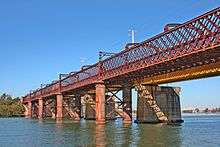
The 1895 iron lattice rail bridge at MeadowBank was replaced as the railway bridge for the Main Northern Railway Line by the John Whitton Bridge in 1980. In 2000 the old bridge was converted to a shared cycle and pedestrian path. Between 300 and 425 cyclists used the Old Meadowbank Rail Bridge on an average weekday in the 12 months to February 2014, with a greater number on the weekend.[4]
Access at the southern (Rhodes) end is via Blaxland Road.
Access to the northern (Ryde) end is via Bay Drive or Bank Street. There are bike paths heading in both directions along the Parramatta River.
Silverwater Bridge
The Silverwater Bridge has a narrow shared cycle and pedestrian path on either side of the bridge.
On the southern (Silverwater) side access is via Clyde Street.
On the northern (Ermington) side, access is via a ramp leading from the Parramatta River
Captain Cook Bridge
The Captain Cook Bridge has a narrow shared cycle and pedestrian path in both directions. Between 125 and 225 cyclists used the Captain Cook Bridge on an average weekday in the 12 months to February 2014, with a greater number on the weekend.[4]
Tom Uglys Bridge
Como Rail Bridge
Between 150 and 300 cyclists used the former Como railway bridge on an average weekday in the 12 months to February 2014.[4]
Alfords Point Bridge
The Alfords Point Bridge has a shared path on the eastern side from Clancy St Padstow Heights to Fowler Road Illawong
Spit Bridge
Whilst more than 400 cyclists commute over the Spit Bridge every day,[16] cyclists are not well catered for, with a choice of negotiating the narrow shared path on the western side or riding on the heavily congested road.
The western path, whilst designated as a shared path, is less than 1.2 metres wide at two points.[17] The bridge itself is only four lanes and heavily congested. The only benefit of the congestion is that traffic is moving slowly whilst crossing the bridge. If you are heading south from Spit Bridge, to avoid cycling up Spit Road, after the bridge take the first left into Parriwi Rd and cycle up the hill. Parriwi Rd reconnects with Spit Road at the top of the hill.
Woronora River Bridge
The Woronora River Bridge has a shared path located just underneath the road. The path can be accessed from Menai Road on the Bangor side and Prince Edward Park Road or River Road on the Sutherland side.
Bike paths
Bay to Bay (Homebush to Cronulla and Kurnell)
The Cooks River Cycleway is a 26 km path between Settlers' Park, Ryde, and Botany Bay at Kyeemah.[18] The Cooks River Cycleway connects to the Parramatta Valley Cycleway at Settlers' Park, Ryde, to Sydney Olympic Park & Bicentennial Park at Rhodes, and with the Brighton Le Sands cycleway,[19] which runs south as far as Cronulla. Much of the length is shared cycleway and footpath, though there is some on-road at the Homebush end, and from Captain Cook Bridge at Taren Point to Kurnell and Cronulla. Anecdote suggests that the section linking Princes Highway, Tempe to Kyeemah Reserve has some non-intuitive routefinding[20] and may benefit from additional signage.
See also Cooks River.
Parramatta Valley Cycleway
A 12 km shared path runs from Putney to Parramatta.[21] There is a short on-road section along Lancaster Rd Melrose Park, an elevated steel mesh boardwalks through Ermington Nature Reserve. There is a further short on-road section via Pike St and South St Rydalmere to Vineyard Creek. There is an elevated steel mesh boardwalk through Baludarri Wetlands.[22] Cyclists have to cross Macarthur St Parramatta then use the Gasworks Bridge to continue along the south side of the Parramatta River, before crossing back to the north side at the Parramatta ferry wharf. The decision to put a tunnel through Lennox Bridge was controversial [23] however the tunnel opened in 2015 and now links the cycleway with Parramatta Park. There are connections to Rhodes and Olympic Park via Ryde Bridge or Old Meadowbank Rail Bridge; to Windsor Road Cycleway via Parramatta Park and Westmead and then connecting to the M7 Cycleway and to the M4 Cyclepath via Harris St and Good St Harris Park. Between 175 and 300 cyclists used the Parramatta Valley Cycleway at Rydalmere on an average weekday in the 12 months to February 2014, with a greater number on the weekend.[4]
Sydney Olympic Park and Bicentennial Park
Sydney Olympic Park has over 35 km of cycleways,[24] including a children's circuit, 5.5 km Parklands Circuit, 7.6 km Olympic Circuit, 12.5 km River Heritage Circuit and the Louise Sauvage Pathway.
Liverpool to Parramatta T-way cycleways
Shared paths run along the Liverpool to Parramatta T-way from Hoxton Park Rd, Liverpool to Davis Rd at Wetherill Park, connecting via Horsley Drive and Wetherill Park Reserve. The path rejoins the T-Way at Victoria St to Davis Rd, Wetherill Park. There are connections to Prospect Creek cyclepath, Orphan School Creek cyclepath, Clear Paddock Creek cyclepath. Further towards Parramatta the path runs alongside Cumberland Highway to South Wentworthville then under the M4 and beside Jones Park to emerge beside Pitt Street to the heart of the Parramatta CBD and Parramatta Park.
Much of the route is impaired by the numerous traffic light crossings, with one 4 km section from Stockland Mall to Davis Rd through Wetherill Park having eight sets of traffic lights. By combining with the Lower Prospect Canal, the T-Way cycleway provides continuous off-road path from Hoxton park to Parramatta.
Parramatta to Liverpool Rail Trail Cycleway
There is a 25 km (16 mi) cycle path running mostly along the route of the rail line between Parramatta railway station and Liverpool railway station. Being mostly adjacent to the railway line there are very few road crossings or traffic lights. At the northern end the path passes under the railway line near Granville on a very narrow 1.5 m wide path and then follows back streets before becoming a proper off-road path near Merrylands. At Fairfield the trail passes through some commuter car parks (which are quiet on weekends) and traverses a short section of road. near Canley Vale there is a complicated section that crosses two railway bridges and two roads in the space of 100 metres (or less ). Overall, across its 25 km length the path is of a fairly high standard, but on weekday evenings the path tends to become overwhelmed with pedestrians.
Prospect Canal Reserve Cycleway
A 7.6 km path, part of the Lower Prospect Canal Reserve,[25] from Prospect Reservoir in west to Pipehead at Guildford in the east. Entry and exit points are: Frank St at Guildford, Albert St cnr Tennyson Pde at Guildford, Sherood Rd at Merrylands, Cumberland Hwy at Merrylands, Cumberland Road at Greystanes, Macquarie Road/Taylor Street at Greystanes, Gipps Rd at Greystanes, Bayfield Rd at Greystanes, Hyland Rd at Greystanes, Reconciliation Road at Wetherill Park and Prospect Reservoir. This wonderful ride has no road crossings at all for 6.5 km due to the original canal bridge crossings being retained and used by the cycleway. It is therefore an excellent area for families to ride. There are cycle path connections at the western end to Pemulwuy and Wetherill park, at the eastern end to the Parramatta-Liverpool Rail Trail and at the Cumberland Hwy to the Parramatta-Liverpool T-Way path. An excellent water bubbler has been provided near the Taylor Street access path (2 km west of the Cumberland Highway).
The path was closed at Prospect in 2010 due to works carried out by Boral, resulting in community outcry.[26] The path was restored to working order in September 2010[27] and is currently usable at the western end to the Prospect Dam area boundary with an at grade traffic light crossing of Reconciliation Road. The path remains closed at Prospect Dam due to maintenance work on the dam wall.[28] Community groups continue to fight for a bridge over Reconciliation Road with some funding provided by the previous Labour State government but funding remains uncompleted as of March 2014.
During 2013 a major underground electricity cable was laid through the reserve alongside the path and many of the entry/exit paths were then replaced.
Prospect Creek Cyclepath
Running mostly alongside Prospect Creek, this 8 km cycleway connects Fairfield to the Prospect Reservoir, joining onto the Parramatta to Liverpool rail trail and the Prospect Canal Reserve cycleway at each end. The path mostly travels through parkland and is almost entirely off-road, except for a short on-road section along Douglas St and Ace Ave. Despite its length, only three roads are crossed, Fairfield Rd, Cumberland Hwy, and Gipps Rd, with grade separated underpasses for each road. The Gipps Rd underpass can fill with water during heavy rain, however an at grade crossing nearby can be used. Two parallel paths exist on the north and south sides of Prospect Creek through Fairfield Road Park, the former sitting within Cumberland Council and the latter within Fairfield City Council. The path on the south ( Fairfield ) side provides the best through route to the Rail Trail and Fairfield. At points along the path local councils have created aboriginal information sites that are well worth stopping at.
Orphan School Creek Cyclepath
There is a 10 km shared path along Orphan School Creek from Canley Vale railway station to Abbotsbury. It connects to the Parramatta to Liverpool Rail Trail Cycleway at Canley Vale railway station, to the Clear Paddock Creek shared path at King Road, Fairfield West, to the Liverpool to Parramatta T-way at Myrtle Rd, and to the Prospect Dam to Abbotsbury cyclepath at Abbotsbury. An attraction of this path is the complete lack of traffic lights although the multiple at grade road crossings in Greenfield Park can be difficult to cross with children. The major crossing of Smithfield Road is at grade and quite dangerous.
An excellent loop ride is possible by combining the Orphan School Creek path with the Parramatta-Liverpool Rail Trail, the Lower Prospect Canal and Prospect Dam to Abbotsbury paths. This entire loop is about 35 km (22 mi) in length and there are only two traffic lights to stop cyclists on the entire loop. The loop can be shortened by using the Parramatta-Liverpool T-Way path instead, though this path has at least eight traffic light crossings through Wetherill Park.
Prospect Dam to Abbotsbury Cyclepath
An 8 km fully paved section of off-road cycleway runs from the dam wall picnic ground to the Fairfield City Farm at Abbotsbury. The one major road crossing of Horsely Drive has traffic lights, another smaller road is crossed at grade. Connection alongside Horsely Drive to the M7 path is also an off-road path. Excellent access to Western Sydney Regional Park and a large number of mountain bike trails of all standards. There is a rest area (called The Dairy) with toilets and drinkable water. There is no development along the route and therefore no nearby vehicle traffic or pedestrians. The section between Horsely Drive and The Dairy is particularly enjoyable with small undulations and smooth bends. There is a steep descent and climb near the City Farm. A short detour can be made up a very steep hill to "Moonrise" for excellent views of the Sydney Basin.
Windsor Road Cycleway
There is a 21 km cyclepath between Parramatta Park and Macquarie Street Windsor[29] which travels mostly alongside the North West T-way from Darcy Road, Westmead to Windsor. Some major road crossings are required, particularly on Old Windsor Road but all are controlled by traffic lights. There are connections to the Parramatta Valley Cycleway via Parramatta Park, Toongabbie and Girraween Creek via McCoy Park, Toongabbie Creek cycleway, Blacktown via Sunnyholt Rd cycleway and to the M7 cycleway at Bella Vista.
Between Rouse Hill and Westmead (14 km) there are some 26 traffic light controlled road crossings and therefore riding along this cycleway is a very stop-start process. There is a steep climb from Abbott Rd up to Seven Hills Road when travelling north.
The Bay Run
The Bay Run is a 7 km shared path (with some sections of separated cycle path) that encircles Iron Cove in Inner West Sydney. Many cyclist commuters use parts of the Bay Run, either to access Lilyfield Road or the Iron Cove Bridge. The Bay run is also popular with people walking and running. As a result, some pedestrians spill onto the separated cycle path, especially in the most popular times such as summer evenings. The path is now entirely off road.
Access to and from the Bay Run between Formosa St, Drummoyne, and Brent St, Russell Lea is poor, with the only access point being Henley St Drummoyne, which is obstructed by a power pole.
The location and markings of the sections of separated cycle path is confusing as in some places the bike path is painted red, e.g. between Waterfront Drive and Leichhardt Rowing Club and in other the footpath is painted red, e.g. between Rodd Park to Barnstaple Road. Similarly in some places the bike path is on the Bay side of the footpath, e.g. between Leichhardt Rowing Club and Maliyawul Street, while in other places it is on the inland side of the footpath, e.g. along Henley Marine Drive from Duke Avenue to Thompson Street.
As of September 2016, works are in progress to widen the bike path and segregate it from from the pedestrian path in either direction from the bridge that was constructed across the Iron Cove Creek Canal (near the intersection of Timbrell Drive and the City West Link) earlier in the year.
Bay to Mountains Cycleway
This major infrastructure project was proposed as part of the 2000 Olympic games works to link Olympic Park with the Olympic Veledrome at Bankstown and the mountain bike and equestrian centre at Abbotsbury. A rough figure-8 route was designed joining Olympic park with Bass Hill, Abbotsbury, Prospect and Guildford. Works over the years have seen a large portion of the western loop of the route constructed from Bankstown Veledrome to Abbotsbury, Prospect Dam and Guildford. The part of this loop from the velodrome north to Sefton is yet to be constructed but there is a short section beside Duck River from South Granville to Auburn. There has been little work on the eastern loop from Sefton to Auburn however a path near the M4 is completed between North Auburn and Olympic Park.
Bass Hill (Bankstown Veledrome) to Canley Vale
A 6 km off-road cyclepath through Mirrembeena Regional Park. Excellent riverside paths through the regional park with an overpass over Henry Lawson Drive. Joins to the Parramatta-Liverpool Rail Trail and Orphan School Creek paths. The double traffic light crossing of Hume Hwy is safe but tedious.
Toongabbie Creek/Windsor Road Cycleway
A 6 km off road cyclepath through Baulkham Hills that connects Old Windsor Rd with Windsor Road. Mostly following the Toongabbie Creek. The path is narrow in places though well defined, and has a couple of short steep sections going under some roads. While there are a couple of quiet street crossings there are no major roads to cross. There are other joining paths through Sophia Doyle Res creating alternative routes.
Bush trails
- Anderson's Fire Trail
- Lady Carington Drive
- Leura - Mt Hay
- Manly Dam
- Mt York - Lawson's Long Alley
- Mt York - Berghofer's Pass
- Narrow Neck
- Newnes Junction to Newnes Town
- Woodford - Glenbrook Fire Trail
See also
References
- ↑ "Australian Bike Trails in Google Maps".
- ↑ "Australian Bike Trails in Google Earth".
- ↑ Bibby, Paul (27 April 2009). "Roads to nowhere leave cyclists fuming". The Sydney Morning Herald. Retrieved 3 December 2016.
- 1 2 3 4 5 6 7 8 9 10 11 12 "Cycling statistics". Roads and Maritime Services. Government of New South Wales. March 2016.
- ↑ "M2 Upgrade Cyclist route during construction" (PDF). Transurban. Archived from the original (PDF) on 4 March 2016.
- ↑ "Official Response to M2 Upgrade Alternative Cycle Route". Pushon. Bicycle NSW. Archived from the original on 16 February 2011.
- ↑ NSW Transport Road Projects
- ↑ "M2 citybound alternate route" (PDF). Transurban. Archived from the original (PDF) on 4 March 2016.
- ↑ "Westlink M7 Map with text" (PDF). Transurban. Archived (PDF) from the original on 2 November 2016.
- 1 2 "NSW Bikeplan 2010" (PDF). Archived from the original (PDF) on 19 May 2012.
- ↑ "King Street West". www.sydneycycleways.net/. Archived from the original on 10 September 2015.
- ↑ "Union Street cycleway". www.sydneycycleways.net/. Archived from the original on 10 September 2015.
- ↑ "Canada Bay Bike Plan 2005" (PDF). Archived from the original (PDF) on 30 March 2012.
- ↑ "Strategic Review of Bike Plan - Final Report" (PDF). April 2014.
- ↑ "Gladesville Bridge". Chain Mail No 51, March 2007. Bike North. Archived from the original on 29 February 2016.
- ↑ "Spit Bicycle and Pedestrian Infrastructure Project". Archived from the original on 20 June 2014.
- ↑ There's no margin for error on Spit Bridge
- ↑ "Cycle way to Botany Bay". Canterbury-Bankstown Council. Archived from the original on 15 June 2015.
- ↑ "Rockdale City Council Cycleways" (PDF). City of Rockdale. Archived from the original (PDF) on 21 June 2014.
- ↑ "Comments at MyColleaguesAreIdiots.com". Blog "A Drunken Madman". Retrieved 30 January 2012.
- ↑ "Cycling in Sydney: Ryde Bridge to Parramatta Park". Retrieved 4 July 2015.
- ↑ "Baludarri Wetlands path froms cycleway link". Parramatta Sun. NSW. 7 January 2015.
- ↑ "Outrage over plan to put tunnels through convict-built bridge". The Sydney Morning Herald. NSW. 5 November 2012.
- ↑ "Sydney Olympic Park Cycling"
- ↑ "Lower Prospect Canal Reserve". Holyroyd Council. Archived from the original on 17 March 2012.
- ↑ "Build our bridge campaign". Canal Reserve Action Group. Archived from the original on 18 October 2016./
- ↑ "Lower prospect canal reserve - "traffic reports"". Archived from the original on 14 October 2016.
- ↑ "Cyclists pleased with bridge over divide". Parramatta Sun.
- ↑ Trailflix: Windsor Road Cycleway - Detailed Trail Info
External links
- Bicycle NSW website
- City of Sydney - Cycling
- Sydney Cycling Map (PDF) (Map). City of Sydney. April 2016.
- "NSW Bike Plan". Bicycle Information for New South Wales.
- "Cycleway Finder". Roads & Maritime Services (Version 3 ed.). Government of New South Wales. 2016.
- Cycling on Anzac Bridge
- Trailflix guide to Sydney's MTB Trails & off-road Cycleways