Big Clifty, Kentucky
| Big Clifty | |
|---|---|
| Unincorporated community | |
 Big Clifty  Big Clifty Location within the state of Kentucky | |
| Coordinates: 37°32′44″N 86°9′13″W / 37.54556°N 86.15361°WCoordinates: 37°32′44″N 86°9′13″W / 37.54556°N 86.15361°W | |
| Country | United States |
| State | Kentucky |
| County | Grayson |
| Elevation | 397 ft (121 m) |
| Time zone | Central (CST) (UTC-6) |
| • Summer (DST) | CST (UTC-5) |
| ZIP codes | 42712 |
| GNIS feature ID | 487153[1] |
Big Clifty is an unincorporated community in Grayson County, Kentucky, United States.
History of Big Clifty
Clifty Creek crosses Highway 62 and the P & L railroad several miles to the southwest of Big Clifty. It is said that travelers named the town due to the limestone cliffs that arose on the sides of Clifty Creek. Accounts of residents from the past report that Big Clifty was a "boom town" that at one time had a post office, bank, feed mill, several dry goods stores and restaurants. The Ben Goodman school was the local "country school" and the town had numerous churches. In yesteryear nearby Clarkson was a tourist destination due to the numerous hotels near Grayson Springs, which were visited by guests who wished to experience the sulphur water's curative properties. Big Clifty benefited from the traffic going to Clarkson. Spurrier Mill was a grist mill on the Nolin River, several miles from Big Clifty which was a benefit to the economy. Like many rural Kentucky communities, as passenger rail-use decreased and transportation and commercial shipping routes changed, Big Clifty's boom town status disappeared.
Big Clifty is also home to film / television actor Tim Skees, 1971-.
The Skees family owned many of the towns businesses in early 1900's, including the funeral home, railway shipping station and several mercantile stores.
Geography of Big Clifty
The town itself is on flat land. The surrounding terrain is flat to rolling with 20 to 40 foot cliffs surrounding Petty Branch of Meeting Creek and Meeting Creek in the Northeast. Clifty Creek runs to the west of Big Clifty with high ridges and cliffs surrounding it. The small community of St. Paul is nearby Big Clifty and Rough River runs west of it. The geography around Rough River is rugged with very high ridges and 40–60 foot cliffs bordering the river in many areas.
References
http://www.imdb.com/name/nm6512359/
Municipalities and communities of Grayson County, Kentucky, United States | ||
|---|---|---|
| Cities | 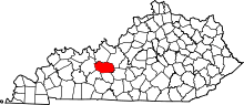 | |
| Unincorporated communities | ||