Berney Arms Windmill
| Berney Arms Windmill | ||
| Windmill | ||
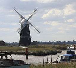 Berney Arms Windmill. | ||
|
||
| Country | England | |
|---|---|---|
| State | Norfolk | |
| Region | East of England | |
| District | Broadland | |
| Municipality | Reedham | |
| Coordinates | 52°35′12″N 1°38′16″E / 52.58657°N 1.63788°ECoordinates: 52°35′12″N 1°38′16″E / 52.58657°N 1.63788°E | |
| Height | 21.5188 m (71 ft) | |
| Founded | 1865 | |
| Owner | Managed by English Heritage | |
| Visitation | Open to public on Mondays only (3½ miles NE of Reedham on the N bank of River Yare. Accessible by hired boat, by footpath from Halvergate (3½ miles), or by ¼ mile walk from railway station) | |
 Berney Arms Windmill within Norfolk
| ||
| Website: http://www.english-heritage.org.uk/server/show/nav.12272 | ||
| Map Ref: TG465049 | ||

Berney Arms Windmill is located at Berney Arms alongside the River Yare at the south-western end of Breydon Water in the English county of Norfolk.[1] The windmill is in an isolated spot in The Broads around 3.5 miles (5.6 km) north-east of the village of Reedham and 4 miles (6.4 km) south-west of Great Yarmouth. The mill has no road access but can be accessed by boat, by foot or from Berney Arms railway station.[2] It is a Scheduled Ancient Monument under the care of English Heritage.
Description
The windmill is 21.5 metres (71 ft) tall[3] and is the tallest drainage windmill in Norfolk.[4] It is constructed from red brickwork with the outside sloping walls coated with tar. The mill tower stands seven storeys high. The cap resembles an upturned clinker boat hull and is a traditional style for Norfolk.[3][4] The windmill has four sails and a fantail. The mill's scoop wheel stands some way from the mill, which is unusual. The scoop wheel is linked to the mill by a horizontal shaft and has a diameter of 7.3 metres (24 ft),[4] with long wooden paddles. The paddles scooped water into a narrow brick-built culvert and released it to the higher level of the River Yare.
History
The windmill was built in 1865 for the Reedham Cement Company by the millwright firm of Stolworthy[4][5][6] on the site of a previous mill.[7] It was initially used to grind cement clinker, using chalk from Whitlingham near Norwich and clay dredged from Oulton Broad or Breydon Water, both brought to the mill by wherry.[8] These materials were fired at nearby kilns. The kilns produced a clinker which was ground to a powder in the windmill. At this time the cement worlks supported a small settlement with 11 inhabited houses and a chapel.[8]
Cement production closed down in 1880 and in 1883 the windmill was converted to work the drainage scoop to drain the surrounding marshland.[2] The mill closed in 1948 when it was replaced by motor pumps.[3][5][7][9] It was given to the Ministry of Works in 1951 and restoration begun in 1967.[3]
The Windmill today
The windmill is a Scheduled Ancient Monument under the care of English Heritage.[7][10] It underwent a lengthy restoration programme starting in 1999 when the sails were removed along with the cap and fantail. After a long period without them the cap was replaced during 2003, the fantail on 22 April 2006 and finally the sails on 25 May 2007. During the Summer of 2009 English Heritage, in partnership with a local boat touring company, re-opened the mill on a limited basis on a number of Mondays. It is now only open to pre-booked group tours.[2] RSPB volunteers, on behalf of English Heritage, have opened the mill on the last Sunday of each month during 2016 and intend to do so in coming years during the summer months.
References
- ↑ The Norfolk Windmill Trust, Windmills to Visit Guide. 3rd Edition, 1982, Page 16. The Morris Printing Co Ltd, 57-61 Pitt Street, Norwich - description & location details.
- 1 2 3 Berney Arms Windmill, English Heritage. Retrieved 2014-02-19.
- 1 2 3 4 Historic England. "Berney Arms Windmill (133775)". PastScape. Retrieved 2014-02-19.
- 1 2 3 4 Windmills - information for teachers, English Heritage, 2003. Retrieved 2014-02-19.
- 1 2 Reedham Berney Arms drainage mill, Norfolk Windmills website. Retrieved 2014-02-19.
- ↑ Labrum, E.A (1993) Civil Engineering Heritage: Eastern and Central England, Thomas Telford Ltd (p.129).
- 1 2 3 Berney Arms high mill, Norfolk Heritage Explorer, Norfolk County Council. Retrieved 2014-02-19.
- 1 2 Local character area 19 - Halvergate marshes (excluding Bure loop and the west of Tunstall dyke) Broads landscape character assessment, Broads Authority, 2006. Retrieved 2014-02-20.
- ↑ Berney Arms Windmill Archived February 24, 2014, at the Wayback Machine., Engineering timelines. Retrieved 2014-02-19.
- ↑ Historic England. "Berney Arms windmill (1003957)". National Heritage List for England. Retrieved 2014-02-19.
External links
| Wikimedia Commons has media related to Berney Arms Windmill. |
- Berney Arms Windmill at Berney Arms Web
- Berney Arms Windmill at English Heritage