Bellwood, Pennsylvania
| Bellwood, Pennsylvania | |
|---|---|
| Borough | |
 Bellwood | |
| Coordinates: 40°36′06″N 78°20′01″W / 40.60167°N 78.33361°WCoordinates: 40°36′06″N 78°20′01″W / 40.60167°N 78.33361°W | |
| Country | United States |
| State | Pennsylvania |
| County | Blair |
| Settled | 1877 |
| Incorporated | 1898 |
| Government | |
| • Type | Borough Council |
| • President | Wayne Snare |
| Area | |
| • Total | 0.5 sq mi (1.2 km2) |
| Population (2010) | |
| • Total | 1,828 |
| • Density | 4,361.8/sq mi (1,692.1/km2) |
| Time zone | Eastern (EST) (UTC-5) |
| • Summer (DST) | EDT (UTC-4) |
| Zip code | 16617 |
| Area code(s) | 814 |
| Website | Bellwood-Antis Community |
Bellwood is a borough in Blair County, Pennsylvania, United States. It is part of the Altoona, PA Metropolitan Statistical Area. The population was 1,828 at the 2010 census.
Geography
Bellwood is located at 40°36′6″N 78°20′1″W / 40.60167°N 78.33361°W (40.601566, -78.333616).[1]
According to the United States Census Bureau, the borough has a total area of 0.5 square miles (1.3 km2), all of it land. Bellwood is a rural area situated in the Tuckahoe Valley, part of the Logan Valley area. Bellwood was originally called Bell's Mills.[2] The Borough of Bellwood is surrounded by the Township of Antis.
Founded
Bellwood's first resident was Edward Bell who moved here with his wife, mother, and father John Bell in 1806.[2] Edward Bell's son, Martin Bell, founded the Sabbath Rest Foundry located in Antis Township (Pinecroft) so-called because he invented a new way to stoke the fires and leave them burn Sunday without having any person attend to them.[2]
Demographics
| Historical population | |||
|---|---|---|---|
| Census | Pop. | %± | |
| 1880 | 300 | — | |
| 1890 | 1,146 | 282.0% | |
| 1900 | 1,545 | 34.8% | |
| 1910 | 2,277 | 47.4% | |
| 1920 | 2,620 | 15.1% | |
| 1930 | 2,560 | −2.3% | |
| 1940 | 2,772 | 8.3% | |
| 1950 | 2,559 | −7.7% | |
| 1960 | 2,330 | −8.9% | |
| 1970 | 2,395 | 2.8% | |
| 1980 | 2,114 | −11.7% | |
| 1990 | 1,976 | −6.5% | |
| 2000 | 2,016 | 2.0% | |
| 2010 | 1,828 | −9.3% | |
| Est. 2015 | 1,786 | [3] | −2.3% |
| Sources:[4][5][6] | |||
As of the census[5] of 2000, there were 2,016 people, 776 households, and 555 families residing in the borough. The population density was 4,361.8 people per square mile (1,692.1/km²). There were 822 housing units at an average density of 1,778.5 per square mile (689.9/km²). The racial makeup of the borough was 98.81% White, 0.10% African American, 0.05% Native American, 0.20% Asian, 0.20% from other races, and 0.64% from two or more races. Hispanic or Latino of any race were 0.89% of the population.
There were 776 households, out of which 32.7% had children under the age of 18 living with them, 55.5% were married couples living together, 10.8% had a female householder with no husband present, and 28.4% were non-families. 24.5% of all households were made up of individuals, and 12.0% had someone living alone who was 65 years of age or older. The average household size was 2.54 and the average family size was 3.01. In the borough the population was spread out, with 25.5% under the age of 18, 7.3% from 18 to 24, 28.6% from 25 to 44, 21.5% from 45 to 64, and 17.1% who were 65 years of age or older. The median age was 37 years. For every 100 females there were 89.8 males. For every 100 females age 18 and over, there were 84.7 males.
The median income for a household in the borough was $34,595, and the median income for a family was $40,091. Males had a median income of $28,869 versus $17,424 for females. The per capita income for the borough was $14,323. About 5.6% of families and 9.3% of the population were below the poverty line, including 13.7% of those under age 18 and 12.8% of those age 65 or over.
Nearby communities
Altoona, Bedford, Coalport, Duncansville, Ebensburg, Hollidaysburg, Huntingdon, Johnstown, State College, Tyrone, and Warriors Mark are nearby.
References
- ↑ "US Gazetteer files: 2010, 2000, and 1990". United States Census Bureau. 2011-02-12. Retrieved 2011-04-23.
- 1 2 3 "BA.net-The Early Settlement of Antis Township". Retrieved 4 December 2016.
- ↑ "Annual Estimates of the Resident Population for Incorporated Places: April 1, 2010 to July 1, 2015". Retrieved July 2, 2016.
- ↑ "Census of Population and Housing". U.S. Census Bureau. Archived from the original on 11 May 2015. Retrieved 11 December 2013.
- 1 2 "American FactFinder". United States Census Bureau. Archived from the original on 2013-09-11. Retrieved 2008-01-31.
- ↑ "Incorporated Places and Minor Civil Divisions Datasets: Subcounty Resident Population Estimates: April 1, 2010 to July 1, 2012". Population Estimates. U.S. Census Bureau. Archived from the original on 17 June 2013. Retrieved 11 December 2013.
External links
- Bellwood-Antis Community Site
- Bellwood-Antis Public Library
- Bellwood-Antis School District
- Bellwood Football (BAHS Football)
- Bellwood Sportsmen's Association
Municipalities and communities of Blair County, Pennsylvania, United States | ||
|---|---|---|
| City | 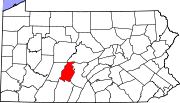 | |
| Boroughs | ||
| Townships | ||
| CDPs | ||
| Unincorporated communities | ||
| Footnotes | ‡This populated place also has portions in an adjacent county or counties | |