Belalie East, South Australia
| Belalie East South Australia | |||||||||||||
|---|---|---|---|---|---|---|---|---|---|---|---|---|---|
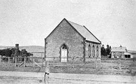 Former Presbyterian Church in 1910 | |||||||||||||
| Postcode(s) | 5491 [1] | ||||||||||||
| LGA(s) | Northern Areas Council [1] | ||||||||||||
| State electorate(s) | Stuart [1] | ||||||||||||
| Federal Division(s) | Grey [1] | ||||||||||||
| |||||||||||||
Belalie East is a rural locality in the Mid North region of South Australia. It is situated in the Northern Areas Council.[1] The boundaries were formally established in April 2001 for the long established local name, relating to the cadastral Hundred of Belalie; however, the modern locality is divided between Belalie and the adjacent Hundred of Whyte.[2]
The Wilkins Highway runs roughly diagonally through the centre of Belalie East, connecting Jamestown and Hallett.[2]
The Belalie East school opened in 1878 and closed in 1959.[3] The Belalie East Memorial Hall opened on 1 September 1923, and survives today.[3][4] A Presbyterian church was built in 1881; its date of closure is unknown.[5] It also formerly had its own coursing club.[6] Belalie East has had three post offices: the first operated between 11 June 1873 and 2 May 1876, the second operated between 1 November 1883 and 31 March 1892 and the third operated between approximately 1896 and 1898.[7][8][9]
The historic Coolootoo Shepherd's Hut, a remnant of the significant Old Canowie Station, is located on the boundary between Belalie East and its southern neighbour Mayfield, and is listed on the South Australian Heritage Register.[10]
References
- 1 2 3 4 5 "Search result(s) for Belalie East, 5491". Location SA Map Viewer. Government of South Australia. Retrieved 3 April 2016.
- 1 2 "Search result(s) for Belalie East, 5491". Property Location Browser. Government of South Australia. Retrieved 3 April 2016.
- 1 2 "Place Names of South Australia - B". State Library of South Australia. Retrieved 3 April 2016.
- ↑ "Minutes of the Special Meeting of the Northern Areas Council held in the Council Chamber 94 Ayr Street, Jamestown on Monday 13 July 2015" (PDF). Retrieved 3 April 2016.
- ↑ "A FAITHFUL PASTORATE.". Christian Colonist. III, (126). South Australia. 4 March 1881. p. 2. Retrieved 4 April 2016 – via National Library of Australia.
- ↑ "Death Of Mr. Ben Williams". The Advertiser (Adelaide). 95, (29,395). South Australia. 29 December 1952. p. 7. Retrieved 4 April 2016 – via National Library of Australia.
- ↑ "Belalie East (1)". Post Office Reference. Premier Postal. Retrieved 3 April 2016.
- ↑ "Belalie East (2)". Post Office Reference. Premier Postal. Retrieved 3 April 2016.
- ↑ "Belalie East (3)". Post Office Reference. Premier Postal. Retrieved 3 April 2016.
- ↑ "Coolootoo Shepherd's Hut". South Australian Heritage Register. Department of Environment, Water and Natural Resources. Retrieved 3 April 2016.
Coordinates: 33°16′11″S 138°39′18″E / 33.2696°S 138.655080°E