Beeler, Kansas
| Beeler, Kansas | |
|---|---|
| Unincorporated community | |
|
George Washington Carver homestead site, south of Beeler | |
 KDOT map of Ness County (legend) | |
 Beeler, Kansas  Beeler, Kansas Location within the state of Kansas | |
| Coordinates: 38°26′40″N 100°11′41″W / 38.44444°N 100.19472°WCoordinates: 38°26′40″N 100°11′41″W / 38.44444°N 100.19472°W | |
| Country | United States |
| State | Kansas |
| County | Ness |
| Time zone | Central (CST) (UTC-6) |
| • Summer (DST) | CDT (UTC-5) |
| ZIP codes | 67518 |
| Website | Website |
_looking_N_1.JPG)
Beeler (also Beelerville) is an unincorporated community in western Ness County, Kansas, United States. It lies along K-96, west of the city of Ness City, the county seat of Ness County.[1] Its elevation is 2,490 feet (759 m), and it is located at 38°26′40″N 100°11′41″W / 38.44444°N 100.19472°W (38.4444607, -100.1948550).[2] Although it is unincorporated, it has a post office, with the ZIP code of 67518.[3]
History
Beeler was a station and shipping point on the Atchison, Topeka and Santa Fe Railway.[4] Elmer Beeler, the town's founder, is its namesake.[5]
The first post office in Beeler was established in 1886 as Beelerville.[6]
Climate
The climate in this area is characterized by hot, humid summers and generally mild to cool winters. According to the Köppen Climate Classification system, Beeler has a humid subtropical climate, abbreviated "Cfa" on climate maps.[7]
References
- ↑ Rand McNally. The Road Atlas '08. Chicago: Rand McNally, 2008, p. 40.
- ↑ Geographic Names Information System Feature Detail Report, Geographic Names Information System, 1978-10-13. Accessed 2008-04-12.
- ↑ Zip Code Lookup
- ↑ Blackmar, Frank Wilson (1912). Kansas: A Cyclopedia of State History, Embracing Events, Institutions, Industries, Counties, Cities, Towns, Prominent Persons, Etc. Standard Publishing Company. p. 169.
- ↑ "Profile for Beeler, Kansas". ePodunk. Retrieved 19 June 2014.
- ↑ "Kansas Post Offices, 1828-1961, page 2". Kansas Historical Society. Retrieved 19 June 2014.
- ↑ Climate Summary for Beeler, Kansas
External links
Municipalities and communities of Ness County, Kansas, United States | ||
|---|---|---|
| Cities | 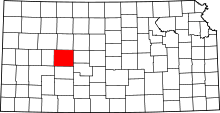 | |
| Unincorporated communities | ||