Beaver Run (Bowman Creek)
| Beaver Run | |
|---|---|
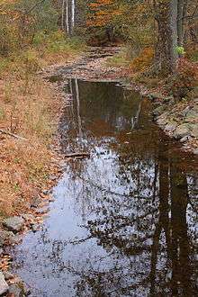 Beaver Run looking downstream near its mouth in Noxen | |
| Basin | |
| Main source |
wetland on Kocher Mountain in Lake Township, Luzerne County, Pennsylvania between 2,100 and 2,120 feet (640 and 646 m) |
| River mouth |
Bowman Creek in Noxen Township, Wyoming County, Pennsylvania 948 ft (289 m) 41°24′57″N 76°02′42″W / 41.41573°N 76.04509°WCoordinates: 41°24′57″N 76°02′42″W / 41.41573°N 76.04509°W |
| Progression | Bowman Creek → Susquehanna River → Chesapeake Bay |
| Basin size | 10.6 sq mi (27 km2) |
| Physical characteristics | |
| Length | 7.7 mi (12.4 km) |
| Features | |
| Tributaries |
|
Beaver Run is a tributary of Bowman Creek in Luzerne County and Wyoming County, in Pennsylvania, in the United States. It is approximately 7.7 miles (12.4 km) long and flows through Lake Township in Luzerne County and Noxen Township in Wyoming County.[1] The watershed of the stream has an area of 10.6 square miles (27 km2). It is not designated as an impaired waterbody. The surficial geology in its vicinity includes alluvial fan, alluvial terrace, alluvium, Wisconsinan Till, Wisconsinan Ice-Contact Stratified Drift, fill, wetlands, and bedrock.
Beaver Run is a source of flooding in Lake Township, Luzerne County. A number of bridges have also been constructed over Beaver Run. The watershed of the stream is designated as a High Quality Coldwater Fishery and a Migratory Fishery.
Course

Beaver Run begins in a wetland on Kocher Mountain in Lake Township, Luzerne County. It flows east-southeast for several tenths of a mile before turning south and then east. Several tenths of a mile further downstream, the stream reaches the base of the mountain and turns north-northeast, flowing through a valley. It heads in this direction for a few miles, flowing alongside Pennsylvania Route 29, receiving two unnamed tributaries from the left, and passing through a wetland after its valley broadens. The stream then exits Lake Township and Luzerne County.[1]
Upon exiting Luzerne County, Beaver Run enters Noxen Township, Wyoming County. It heads in a northeasterly direction near Sorber Mountain for several tenths of a mile before receiving an unnamed tributary from the right and turning north-northwest, still flowing alongside the mountain. The stream then turns north, crossing Pennsylvania Route 29 and passing between Sorber Mountain and Grassy Ridge. After more than a mile, it enters the census-designated place of Noxen and turns northeast before leaving its valley and turning east. After several tenths of a mile, the stream gradually turns east-southeast, and several tenths of a mile after that, it reaches its confluence with Bowman Creek.[1]
Beaver Run joins Bowman Creek 12.36 miles (19.89 km) upstream of its mouth.[2]
Hydrology
Beaver Run is not designated as an impaired waterbody.[3]
At Greenbriar Road, where Beaver Run drains 2.35 square miles (6.1 km2), the stream's peak annual discharge has a 10 percent chance of reaching 468 cubic feet per second (13.3 m3/s). It has a 2 percent chance of reaching 853 cubic feet per second (24.2 m3/s) and a 1 percent chance of reaching 1,065 cubic feet per second (30.2 m3/s). The peak annual discharge has a 0.2 percent chance of reaching 1,692 cubic feet per second (47.9 m3/s).[4]
Geography and geology

The elevation near the mouth of Beaver Run is 948 feet (289 m) above sea level.[5] The elevation of the stream's source is between 2,100 and 2,120 feet (640 and 646 m) above sea level.[1]
The surficial geology near the mouth of Beaver Run mainly consists of alluvial terrace, alluvium, and a till known as Wisconsinan Till. The latter two types of surficial geology are also common further upstream, as is Wisconsinan Ice-Contact Stratified Drift. There are also some patches of wetland, alluvial fan, fill, and bedrock consisting of sandstone and shale.[6] The surficial geology further upstream also includes many of these features.[7]
In preglacial times, Harveys Lake, the largest natural lake in Pennsylvania by volume, drained into Beaver Run and Bowman Creek.[6][8] However, Harveys Lake now drains into Harveys Creek instead.[8] During the Ice Age, glaciers receding northeast in the valley of Bowman Creek to the village of Noxen opened the mouth of the valley of Beaver Run, causing the Glacial Lake Beaver Run to become a branch of Glacial Lake Bowman.[6]
Watershed

The watershed of Beaver Run has an area of 10.6 square miles (27 km2).[2] The mouth of the stream is in the United States Geological Survey quadrangle of Noxen. However, its source is in the quadrangle of Harveys Lake.[5]
Some land infringes upon the 100-year floodplain of Beaver Run and at least one of its tributaries.[9]
Beaver Run is one of several major sources of flooding in Lake Township, Luzerne County, with other sources including Harveys Creek, Pikes Creek, and Fades Creek. However, flooding along Beaver Run and the other streams has not caused much damage, as the township is relatively undeveloped.[4]
History
Beaver Run was entered into the Geographic Names Information System on August 2, 1979. Its identifier in the Geographic Names Information System is 1198391.[5]
Historically, the Lewis log train linked with the Lehigh Valley Railroad at Beaver Run, next Noxen.[10] In the late 1800s, a two-span iron bridge replaced a trestle over the stream.[11]
A steel stringer/multi-beam or girder bridge carrying T-327 (Maple Street) over Beaver Run was built 0.75 miles (1.21 km) southeast of Noxen in 1943 and was repaired in 2010. This bridge is 26.9 feet (8.2 m) long. A prestressed box beam or girders bridge carrying T-337 (Beaver Street) was built over the stream in Noxen in 2009 and is 29.9 feet (9.1 m) long.[12]
In 2006, Beaver Run was proposed as a flood debris cleanup site.[13]
Biology
The drainage basin of Beaver Run is designated as a High-Quality Coldwater Fishery and a Migratory Fishery.[14] Wild trout naturally reproduce in the stream from its headwaters downstream to its mouth.[15] Reaches of the stream have in the past been stocked with brook trout.[16]
See also
- South Run (Bowman Creek), next tributary of Bowman Creek going downstream
- Hettesheimer Run, next tributary of Bowman Creek going upstream
- List of rivers of Pennsylvania
- List of tributaries of Bowman Creek
References
- 1 2 3 4 United States Geological Survey, The National Map Viewer, archived from the original on April 5, 2012, retrieved October 9, 2015
- 1 2 Pennsylvania Gazetteer of Streams (PDF), November 2, 2001, p. 32, retrieved October 9, 2015
- ↑ United States Environmental Protection Agency, Assessment Summary for Reporting Year 2006 Pennsylvania, Upper Susquehanna-Tunkhannock Watershed, retrieved October 10, 2015
- 1 2 Federal Emergency Management Agency, Flood Insurance Study Volume 1 of 6 Luzerne County, Pennsylvania (all jurisdictions) (PDF), pp. 23, 46, retrieved October 10, 2015
- 1 2 3 Geographic Names Information System, Feature Detail Report for: Beaver Run, retrieved October 9, 2015
- 1 2 3 Duane D. Braun (2007), Surficial geology of the Noxen 7.5-minute quadrangle, Wyoming and Luzerne Counties, Pennsylvania, pp. 12, 18, retrieved October 10, 2015
- ↑ Duane D. Braun (2007), Surficial geology of the Harveys Lake 7.5-minute quadrangle, Luzerne County, Pennsylvania, p. 18, retrieved October 10, 2015
- 1 2 United States Environmental Protection Agency, Harveys Lake, Pennsylvania – Nonpoint Source Success Story, archived from the original on December 8, 2015, retrieved October 17, 2015
- ↑ Wyoming County Planning Commission (June 30, 2000), Bowman's Creek Watershed Act 167 Stormwater Management Plan Wyoming County, Pennsylvania, p. 29, retrieved October 10, 2015
- ↑ Chapter 2: The Construction Years, Harveys Lake, retrieved October 10, 2015
- ↑ Lehigh Valley Railroad Company (1895), Annual Report of the Board of Directors of the Lehigh Valley Railroad, p. 17
- ↑ Wyoming County, retrieved October 10, 2015
- ↑ Josh Mrozinski (August 23, 2006), "$200k slated for stream bank work", Wyoming County Press Examiner, retrieved October 10, 2015
- ↑ "§ 93.9i. Drainage List I. Susquehanna River Basin in Pennsylvania Susquehanna River", Pennsylvania Code, retrieved October 10, 2015
- ↑ Pennsylvania Fish and Boat Commission (August 2015), Pennsylvania Wild Trout Waters (Natural Reproduction) – August 2015 (PDF), p. 105, retrieved October 10, 2015
- ↑ Pennsylvania Game Commission (1954), Pennsylvania Game News, Volume 25, p. 34