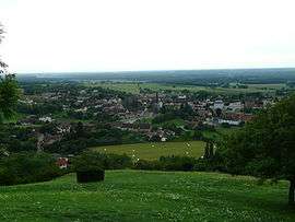
Beaufort, Jura
| Beaufort | ||
|---|---|---|
 | ||
| ||
 Beaufort | ||
|
Location within Bourgogne-Franche-Comté region  Beaufort | ||
| Coordinates: 46°34′27″N 5°26′22″E / 46.5742°N 5.4394°ECoordinates: 46°34′27″N 5°26′22″E / 46.5742°N 5.4394°E | ||
| Country | France | |
| Region | Bourgogne-Franche-Comté | |
| Department | Jura | |
| Arrondissement | Lons-le-Saunier | |
| Canton | Beaufort | |
| Government | ||
| • Mayor (2014–2020) | Jean Franchi | |
| Area1 | 13.11 km2 (5.06 sq mi) | |
| Population (2009)2 | 1,005 | |
| • Density | 77/km2 (200/sq mi) | |
| Time zone | CET (UTC+1) | |
| • Summer (DST) | CEST (UTC+2) | |
| INSEE/Postal code | 39043 / 39190 | |
| Elevation | 191–574 m (627–1,883 ft) | |
|
1 French Land Register data, which excludes lakes, ponds, glaciers > 1 km² (0.386 sq mi or 247 acres) and river estuaries. 2 Population without double counting: residents of multiple communes (e.g., students and military personnel) only counted once. | ||

Beaufort is a commune in the Jura department in the region of Bourgogne-Franche-Comté in eastern France.
Population
| Historical population | ||
|---|---|---|
| Year | Pop. | ±% |
| 1793 | 964 | — |
| 1800 | 877 | −9.0% |
| 1806 | 1,226 | +39.8% |
| 1821 | 1,067 | −13.0% |
| 1831 | 1,178 | +10.4% |
| 1836 | 1,210 | +2.7% |
| 1841 | 1,268 | +4.8% |
| 1846 | 1,215 | −4.2% |
| 1851 | 1,278 | +5.2% |
| 1856 | 1,173 | −8.2% |
| 1861 | 1,255 | +7.0% |
| 1866 | 1,299 | +3.5% |
| 1872 | 1,359 | +4.6% |
| 1876 | 1,301 | −4.3% |
| 1881 | 1,270 | −2.4% |
| 1886 | 1,298 | +2.2% |
| 1891 | 1,240 | −4.5% |
| 1896 | 1,160 | −6.5% |
| 1901 | 1,164 | +0.3% |
| 1906 | 1,166 | +0.2% |
| 1911 | 1,163 | −0.3% |
| 1921 | 1,020 | −12.3% |
| 1926 | 1,022 | +0.2% |
| 1931 | 1,000 | −2.2% |
| 1936 | 966 | −3.4% |
| 1946 | 804 | −16.8% |
| 1954 | 843 | +4.9% |
| 1962 | 841 | −0.2% |
| 1968 | 781 | −7.1% |
| 1975 | 779 | −0.3% |
| 1982 | 896 | +15.0% |
| 1990 | 936 | +4.5% |
| 1999 | 965 | +3.1% |
| 2006 | 1,000 | +3.6% |
| 2009 | 1,005 | +0.5% |
See also
References
| Wikimedia Commons has media related to Beaufort (Jura). |
This article is issued from Wikipedia - version of the 2/11/2016. The text is available under the Creative Commons Attribution/Share Alike but additional terms may apply for the media files.