Battle of Tarakan (1942)
| Battle of Tarakan | |||||||
|---|---|---|---|---|---|---|---|
| Part of World War II | |||||||
 Tarakan island | |||||||
| |||||||
| Belligerents | |||||||
|
|
| ||||||
| Commanders and leaders | |||||||
|
|
| ||||||
| Strength | |||||||
| Over 6,600 | Over 1,300 | ||||||
| Casualties and losses | |||||||
| 255 killed | Nearly all killed in battle or executed after surrendering | ||||||
The Battle of Tarakan took place on January 11–12, 1942, beginning a day after Japan declared war on the Kingdom of the Netherlands. Although Tarakan was only a small marshy island off northeastern Borneo in the Netherlands East Indies, the island's 700 oil wells, oil refinery, and airfield made it a crucial objective for the Empire of Japan in the Pacific War.[3]
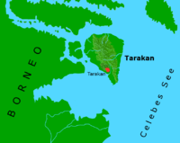
Geography
Tarakan is a triangle shaped island 2.5 miles (4.0 km) off the coast of Borneo. The island is roughly 15 miles (24 km) long from its northernmost point to the southern tip and 11 miles (18 km) wide towards the north of the island. The small island of Sadau is located about 0.5 miles (0.80 km) off Tarakan's west coast. Almost all of Tarakan's coastline is swampy, and in 1945 mangroves on the northern half of the island stretched 1 to 2 miles (1.6 to 3.2 km) inland. The coastal mangroves in the southern portion of the island were narrower. Inland from the swamps, most of central Tarakan comprised a series of steep and densely forested hills just over 100 feet (30 m) high.[4] Tarakan is located three degrees north of the equator and has a tropical climate. The maximum temperature for most days is about 90 degrees Fahrenheit, and relative humidity is consistently high at about 90%.[5]
In 1945, Tarakan Town was the main settlement of the island. This town was located 2,000 yards (1,800 m) inland, and was separated from the south-west coast by several small hills covered in low vegetation. Four piers used to dock oil tankers were located on this coastline, and were connected to Tarakan Town by three surfaced roads. Tarakan airfield was located about 1 mile (1.6 km) north-west of Tarakan Town. Of the island's two oilfields, Sesanip Oilfield was located at the north-east edge of the airfield while the larger Djoeata or Juata Oilfield was 3 miles (4.8 km) to the north. The village of Djoeata was located on Tarakan's north-west coast and linked to Djoeata Oilfield by a track.[4]
The Japanese landing
On January 10, 1942, after a Dutch Dornier Do 24K flying boat spotted an approaching Japanese invasion fleet, the commander of Tarakan's garrison ordered the destruction of all oil installations on the island.[2]
The Japanese forces of the Right Wing Unit from the Sakaguchi Detachment landed on the east coast of Tarakan at midnight on January 11, 1942, followed by the 2nd Kure Special Naval Landing Force. After mounting brief, but fierce resistance, the heavily outnumbered Koninklijk Nederlands Indisch Leger (Royal Netherlands East Indies Army, or KNIL) garrison surrendered in the morning of January 12. All prisoners of war were executed by the Japanese via drowning in retaliation for the destruction of the oil installations,[2] an action that was repeated later following the Battle of Balikpapan.[6][7]
During the night of January 11, before Japan completed the blockade of Tarakan, the Dutch submarine K-X,[2] the patrol boat P-1, and the civilian motor launch Aida slipped away. The Dutch minelayer Prins van Oranje tried to escape as well but was sunk by the Japanese destroyer Yamakaze, under Lt. Cdr Shuichi Hamanaka, and the patrol boat P-38.[3]
Dutch planes flew bombing missions from an airfield in eastern Borneo (called Samarinde II) in order to attack Japanese ships.
Tarakan remained under Japanese occupation until May 1945, when it was liberated by Australian troops in the 1945 Battle of Tarakan.
Order of battle
Ground forces
Japanese Units
Sakaguchi Detachment
- HQ 56th Regimental Group
- Tankette Company
- 146th Infantry Regiment (+)
- I Battalion, 56th Field Artillery Regiment
- 1 Company, 56th Engineer Regiment
- 2 Company, 56th Transport Regiment
- 146th Infantry Regiment (+)
- Infantry elements, 2nd Kure Special Naval Landing Force[8]
- 2nd Oilfield Construction Unit
- 5th Airfield Construction Unit
Dutch Units
Tarakan Garrison
- Tarakan Garrison Battalion (7th KNIL Infantry Battalion)
- Machinegun company
- Motorised detachment with 7 armoured cars[9]
- 3 Coastal Artillery Regiment(?)
- Two mobile coastal artillery batteries (total of 3 × 75 mm guns and 2 × 70 mm guns)
- Five fixed coastal artillery batteries (total of 2 × 120 mm guns, 10 × 75 mm guns and 3 × 37 mm guns)
- Two AA batteries (total of 4 × 40 mm guns and 4 × 20 mm guns)
- Four AA machine gun platoons (each with 3 × 12.7 mm HMG)
- Two engineer platoons
- Mobile Auxiliary First Aid Platoon
References
- ↑ L, Klemen (1999–2000). "Major-General Shizuo Sakaguchi". Forgotten Campaign: The Dutch East Indies Campaign 1941–1942.
- 1 2 3 4 L, Klemen (1999–2000). "The capture of Tarakan Island, January 1942". Forgotten Campaign: The Dutch East Indies Campaign 1941–1942.
- 1 2 Womack, 2006
- 1 2 Rottman (2002), p. 259
- ↑ Stanley (1997), p. 7
- ↑ L, Klemen (1999–2000). "The capture of Balikpapan, January 1942". Forgotten Campaign: The Dutch East Indies Campaign 1941–1942. Archived from the original on July 26, 2011.
- ↑ L, Klemen (1999–2000). "Massacres of POWs, Dutch East Indies, 1941–1942". Forgotten Campaign: The Dutch East Indies Campaign 1941–1942. Archived from the original on September 19, 2011.
- ↑ Yaklitch, Mike; Alsleben, Allan; Takizawa, Akira (1999–2000). "Japanese Special Naval Landing Forces". Forgotten Campaign: The Dutch East Indies Campaign 1941–1942.
- ↑ L, Klemen (1999–2000). "The Use of Armoured Vehicles on Borneo, 1941–1942". Forgotten Campaign: The Dutch East Indies Campaign 1941–1942.
Books
- Womack, Tom (2006), "The Dutch Naval Air Force Against Japan – The Defense of the Netherlands East Indies, 1941–1942", McFarland & Company, Inc., ISBN 0-7864-2365-X
Web
- L, Klemen (1999–2000). "Forgotten Campaign: The Dutch East Indies Campaign 1941–1942". Archived from the original on July 26, 2011.
- Morison, Eliot Samuel (2001), "The Rising Sun in the Pacific 1931 – April 1942", University of Illinois Press, Urbana.
- Niehorster, Dr. Leo, World War II Armed Forces Orders of Battle and Organizations
- The Kingdom of The Netherlands declares war with Japan
Coordinates: 3°21′0″N 117°34′0″E / 3.35000°N 117.56667°E