Batheaston

Coordinates: 51°24′23″N 2°18′40″W / 51.4065°N 2.3112°W
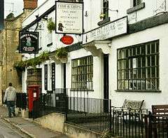
Batheaston is a village and civil parish 2 miles (3.2 km) east of Bath, England (which is believed to be the origin of the name), on the north bank of the River Avon. The parish has a population of 2,735.[1] The northern area of the parish on the road to St Catherine is an area known as Northend.
Batheaston has been twinned with Oudon in France since 2005.[2]
History
Batheaston is named Estone in the Domesday Book.
Batheaston was part of the hundred of Bath Forum.[3][4]
In the 16th century the Lord of the Manor was John Hussey, 1st Baron Hussey of Sleaford.[5]
In the 18th century, Sir John Riggs Miller, 1st Baronet and Anna Miller held a much-mocked fortnightly literary salon along with competitions and prizes at their house in the village. The couple there held a fortnightly literary salon along with competitions and prizes. Distinguished contributions were received from the like of David Garrick, Christopher Anstey and the poet Anna Seward.
Governance
The parish council has responsibility for local issues, including setting an annual precept (local rate) to cover the council’s operating costs and producing annual accounts for public scrutiny. The parish council evaluates local planning applications and works with the local police, district council officers, and neighbourhood watch groups on matters of crime, security, and traffic. The parish council's role also includes initiating projects for the maintenance and repair of parish facilities, such as the village hall or community centre, playing fields and playgrounds, as well as consulting with the district council on the maintenance, repair, and improvement of highways, drainage, footpaths, public transport, and street cleaning. Conservation matters (including trees and listed buildings) and environmental issues are also of interest to the council.
The parish falls within the unitary authority of Bath and North East Somerset which was created in 1996, as established by the Local Government Act 1992. It provides a single tier of local government with responsibility for almost all local government functions within its area including local planning and building control, local roads, council housing, environmental health, markets and fairs, refuse collection, recycling, cemeteries, crematoria, leisure services, parks, and tourism. It is also responsible for education, social services, libraries, main roads, public transport, Trading Standards, waste disposal and strategic planning, although fire, police and ambulance services are provided jointly with other authorities through the Avon Fire and Rescue Service, Avon and Somerset Constabulary and the Great Western Ambulance Service.
Bath and North East Somerset's area covers part of the ceremonial county of Somerset but it is administered independently of the non-metropolitan county. Its administrative headquarters are in Bath. Between 1 April 1974 and 1 April 1996, it was the Wansdyke district and the City of Bath of the county of Avon.[6] Before 1974 that the parish was part of the Bathavon Rural District.[7]
The parish is represented in the House of Commons of the Parliament of the United Kingdom as part of North East Somerset. It elects one Member of Parliament (MP) by the first past the post system of election. It is also part of the South West England constituency of the European Parliament which elects seven MEPs using the d'Hondt method of party-list proportional representation.
Geography

The village is overlooked by Solsbury Hill which is within the Cotswolds Area of Outstanding Natural Beauty and was an Iron Age hill fort occupied between 300 BC and 100 BC. It is also linked to Bathampton on the south bank of the river via a toll bridge, and also borders Bathford.
The Bybrook River which springs up near Marshfield in Gloucestershire, flows through villages such as Castle Combe and Box in Wiltshire before finally merging with the River Avon in Batheaston.
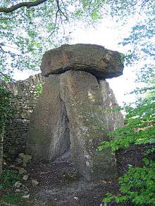
The Roman road of the Fosseway descends into Batheaston via the Bannerdown hill, before joining the London Road (A4) also a former Roman road.[8] The hill rises to 189 metres (620 ft) above sea level, and on the top of the hill rest the Three Shire Stones (three vertical blocks of limestone with a large cap) which mark where the counties of Gloucestershire, Wiltshire and Somerset meet. The stones are formed in the style of a burial chamber, there are three small dressed stones (the original stones) inside, each dated 1736 and with the initial of one of the three counties.[9] The previous Shire stones are shown on a John Speede map dated 1610. Sometime in 1859 a Cromlech was erected over the top of the original stones which possibly were part of a burial chamber, local newspapers and national journals of the time report that three skeletons were found in the hole along with a James II coin whilst the work was being completed, each stone is approx 9–12 feet in height and weigh four to five tons a piece, the cap is of a similar size and weight, the work at the time in 1859 was costed as £34 5s 8d, dinner to the workmen was also included.[10]
The Northern end of the Bannerdown ridge is home to Colerne Airfield, a Second World War RAF Fighter Command and Bomber Command airfield. The hill is littered with former quarries of Bath Stone.[11]
Transport
The 3 miles (5 km) £45 million A46 dual-carriageway Batheaston/Swainswick bypass opened in summer 1996. It joins the main A4 road which used to follow the Fosse Way which runs through the village. It is also on the route of the Limestone Link a 36 miles (58 km) long-distance footpath from the Mendip Hills in Somerset to Cold Aston in the Cotswolds in Gloucestershire.
Religious sites
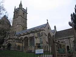
The parish church of Batheaston is the Church of St John The Baptist and the parish is joined with St Catherine. It was built in the 12th century, and remodelled in the late 15th century. The west tower which has four stages with a pierced embattled parapet, setback buttresses, projecting octagonal stairs, and a turret at the south-east corner which terminates in spirelet, was rebuilt in 1834 by John Pinch, the Younger of Bath. It has pointed perpendicular two-light windows with cusped heads and the east side has a canopied niche containing a figure, probably St John.[12]
Landmarks
The Riverside studios in Batheaston have been used by several musicians to record their albums including; Mighty ReArranger by Robert Plant.
Batheaston House was built in 1712 for Henry Walters (1667–1753) a wealthy clothiers who succeeded to the property of Batheaston through his grandfather, Henry Blanchard.[13]
Pine House dates from 1672 having been built for Richard and Mary Panton. It was extended to the north in early 18th century.[14]
Eagle House was built in the late 17th/early 18th century and then remodelled in 1724 and again in 1729 by John Wood, the Elder as his own house. The house has also been an important refuge for suffragettes who had been released from prison after hunger strikes, with trees being planted to commemorate each woman — at least 47 trees were planted between April 1909 and July 1911, including Emmeline Pankhurst, Christabel Pankhurst, Charlotte Despard, Millicent Fawcett and Lady Lytton.[15]
Notable people
- John Josias Conybeare (1779 – 1824), became vicar of Batheaston, and was Professor of Anglo-Saxon (1808–1812), and afterwards Professor of Poetry (1812–1821), at Oxford. He published a translation of Beowulf in English and Latin verse (1814).
- Edmund Fallowfield Longrigg, (usually known as "Bunty"), (1906–1974), played cricket for Somerset and Cambridge University.
- William Lonsdale (1794–1871), geologist and palaeontologist.
- Oswald Stevens Nock (1904–1994), (usually known as O.S. Nock), railway author and signal engineer.
- John Wood, the Younger (1728–1782), architect.
- Patrick Young Alexander (1867–1943 ) aeronautical pioneer
References
- 1 2 "Batheaston Parish". Neighbourhood Statistics. Office for National Statistics. Retrieved 31 December 2013.
- ↑ "Twinning". Bath & North East Somerset Council. Retrieved 1 November 2016.
- ↑ Reverend John Collinson (1791). The History and Antiquities of the County of Somerset. 1. p. 97. ISBN 978-1-171-40217-6.
- ↑ "Somerset Hundreds". GENUKI. Retrieved 9 September 2011.
- ↑ "Medieval Deeds of Bath and District"
- ↑ "The Avon (Structural Change) Order 1995". HMSO. Archived from the original on 30 January 2008. Retrieved 9 December 2007.
- ↑ "Bathavon RD". A vision of Britain Through Time. University of Portsmouth. Retrieved 4 January 2014.
- ↑ Codrington, Thomas (1903). "Chapter VII: The Foss Way". Roman Roads in Britain. Society for Promoting Christian Knowledge. Retrieved 18 August 2010.
- ↑ Gunstone, A J H (1963). "The Date of the Three Shire Stones, Near Batheaston". Proceedings of the Bristol and Gloucestershire Archaeological Society. 82: 210–211.
- ↑ "Three Shire Stones (Reconstruction)". The Modern Antiquarian. Retrieved 21 November 2010.
- ↑ Map of 1884–1887
- ↑ "Parish Church of St John the Baptist, Batheaston". Images of England. Retrieved 5 March 2008.
- ↑ "Batheaston House". Images of England. Archived from the original on 15 October 2012. Retrieved 25 November 2008.
- ↑ "Pine House". Images of England. Archived from the original on 15 October 2012. Retrieved 25 November 2008.
- ↑ "Eagle House". Images of England. Archived from the original on 15 October 2012. Retrieved 25 November 2008.
Further reading
- Willmott Dobbie, Beatrice M. (1969). An English Rural Community: Batheaston with St Catherine. Bath University Press.
External links
| Wikimedia Commons has media related to Batheaston. |