Barraute, Quebec
| Barraute | |
|---|---|
| Municipality | |
 | |
 Location within Abitibi RCM. | |
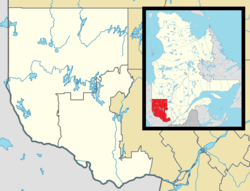 Barraute Location in western Quebec. | |
| Coordinates: 48°26′N 77°38′W / 48.433°N 77.633°WCoordinates: 48°26′N 77°38′W / 48.433°N 77.633°W[1] | |
| Country |
|
| Province |
|
| Region | Abitibi-Témiscamingue |
| RCM | Abitibi |
| Settled | 1910s |
| Constituted | January 5, 1994 |
| Government[2] | |
| • Mayor | Lionel Pelchat |
| • Federal riding | Abitibi—Témiscamingue |
| • Prov. riding | Abitibi-Ouest |
| Area[2][3] | |
| • Total | 504.10 km2 (194.63 sq mi) |
| • Land | 497.97 km2 (192.27 sq mi) |
| Population (2011)[3] | |
| • Total | 1,980 |
| • Density | 4.0/km2 (10/sq mi) |
| • Pop 2006-2011 |
|
| • Dwellings | 986 |
| Time zone | EST (UTC−5) |
| • Summer (DST) | EDT (UTC−4) |
| Postal code(s) | J0Y 1A0 |
| Area code(s) | 819 |
| Highways |
|
Barraute is a municipality in the Canadian province of Quebec, located in the Abitibi Regional County Municipality.
It is home to the Mont-Vidéo Ski Resort.[4]
History
Colonization began after the completion of the National Transcontinental Railway through the Abitibi region. In 1916, the family of Uldéric Hardy arrived, followed by a further twenty in 1917 and, by 1918, the place had a total of some 30 families. The new settlement was initially called Natagan, taken from the Natagan River, a Native American name that means "winding waters." In 1917, the Natagan River Post Office opened, renamed to Barraute in 1919.[1]
In 1918, the United Township Municipality of Fiedmont-et-Barraute was formed, incorporating the geographic townships of Fiedmont and Barraute (proclaimed in 1916). Pierre-Jean Bachoie, called Barraute (1723-1760), was an officer of the Béarn Regiment in the army of General Montcalm and member of the Order of Saint Louis. Fiedmont likewise was an officer of the army of Montcalm.[1]
In 1948, a portion of the municipal territory separated and was incorporated as the Village Municipality of Barraute. In 1950, zinc and silver mines began operating, that in addition to its favourable location along the railroad and Laflamme River (a tributary of the Bell River), contributed to the local prosperity. In 1951, the United Township Municipality of Fiedmont-et-Barraute changed status to just municipality. But the closure of the zinc and silver mines in 1957, as well as the closure in 1965 of Canada's only lithium mine in neighbouring La Corne, dealt a blow to the economy of Barraute.[1]
In 1978, the Town of Barville (incorporated in 1953) was merged into the Municipality of Fiedmont-et-Barraute and, in 1994, the Municipalities of Fiedmont-et-Barraute and Barraute were regrouped into the new Municipality of Barraute.[1]
Economy
In 2012, Quebec Lithium Corp. reopened the lithium mine, which had operated as an underground mine from 1955 to 1965. They are planning to carve an open pit mine over pegmatite dikes. (The pegmatite is about 1% lithium carbonate.) The mine is about 60 kilometres (37 mi) north of Val d'Or, 38 kilometres (24 mi) southeast of Amos, and 15 kilometres (9.3 mi) km west of Barraute. Access to the mine is via paved road from Val d'Or.[5]
Demographics
Population trend:[6]
- Population in 2011: 1980 (2006 to 2011 population change: -4.0%)
- Population in 2006: 2062
- Population in 2001: 2010
- Population in 1996: 2134
- Population in 1991: 2200
Private dwellings occupied by usual residents: 876 (total dwellings: 986)
Mother tongue:[7]
- English as first language: 5.2%
- French as first language: 94.1%
- English and French as first language: 0%
- Other as first language: 0.7%
Municipal council
- Mayor: Lionel Pelchat
- Councillors: Gaétan Alain, Stéphane Alain, Michel Auger, Nancy Habel, Marc Hardy, Michel Leclerc
References
- 1 2 3 4 5 "Barraute (Municipalité)" (in French). Commission de toponymie du Québec. Retrieved 2011-01-11.
- 1 2 "Barraute". Répertoire des municipalités (in French). Ministère des Affaires municipales, des Régions et de l'Occupation du territoire. Retrieved 2011-01-11.
- 1 2 "Barraute census profile". 2011 Census data. Statistics Canada. Retrieved 2011-01-11.
- ↑ "Mont-Vidéo ski maps". skimap.org. Retrieved 2013-03-07.
- ↑ "Quebec Lithium". Canada Lithium Corp. Retrieved 2013-03-07.
- ↑ Statistics Canada: 1996, 2001, 2006, 2011 census
- ↑ "Barraute community profile". 2006 Census data. Statistics Canada. Retrieved 2011-01-11.
 |
La Morandière | Champneuf | | |
| Landrienne La Corne |
|
Belcourt | ||
| ||||
| | ||||
| Val-d'Or | Senneterre (parish) |
| Towns | |
|---|---|
| Municipalities | |
| Townships | |
| Parishes | |
| Unorganized territories | |
| |