Ballymahon
| Ballymahon Baile Uí Mhatháin | |
|---|---|
| Town | |
| Motto: Ag an Éirí an Gealach. | |
 Ballymahon Location in Ireland | |
| Coordinates: 53°34′00″N 7°46′00″W / 53.566667°N 7.766667°WCoordinates: 53°34′00″N 7°46′00″W / 53.566667°N 7.766667°W | |
| Country | Ireland |
| Province | Leinster |
| County | County Longford |
| Elevation | 82 m (269 ft) |
| Population (2016) | |
| • Total | 2,661 |
| Time zone | WET (UTC+0) |
| • Summer (DST) | IST (WEST) (UTC-1) |
| Website |
www |
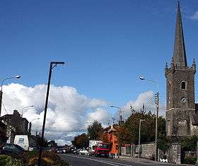
Ballymahon (Irish: Baile Uí Mhatháin, meaning "Mahon's town") on the River Inny is a town in the southern part of County Longford, Ireland. It is located at the junction of the N55 National secondary road and the R392 regional road.
History
Ballymahon derives its name from Gaelic Baile Mathuna (Town of Mahon). This may refer to Mahon (Mathgamain mac Cennétig), a southern chieftain and the elder brother of Brian Boru, who is believed by some to have fought a battle in 960 in the vicinity of Ballymahon at Shrule (in Irish Sruaith Fhuil, River of Blood) where he defeated O'Rourke of Cavan and laid claim to lands in the area. This is disputed by others who claim Mahon may relate to a sub chieftain of the O'Farrells who ruled over this part of County Longford in the 14th century.[1]
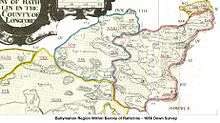
The earliest documentary evidence of Ballymahon was in the year 1578. The map of the Down Survey (1654) by Sir William Petty shows Ballymahon as a group of houses situated at the southern end of the present town, on the right bank of the River Inny.
.
Two main families, the Shuldham family of Moigh House and the King-Harman family of Newcastle House, developed the town in the mid-nineteenth century. The buildings in the town are of late Georgian architecture, with two and three storey gabled houses, colour-washed and in rows of three and four. A special feature of the town is its wide main street. From 1788 to 1853 the Roman Catholic bishops of Ardagh and Clonmacnoise resided in the town and the parish church served as a Pro-Cathedral until St. Mel's Cathedral was built in Longford.
Geography
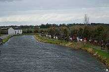
The River Inny, a tributary of the River Shannon, flows westwards through Ballymahon in the direction of Lough Ree three miles from the town. A stretch of the Inny from Newcastle Bridge to Ballymahon town is a renowned route for beginner to intermediate kayaking, canoeing and time trials.


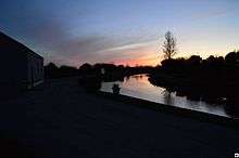
The Royal Canal also passes westwards through Ballymahon from Dublin to Clondra, County Longford. Following extensive works the canal has recently been restored and is now fully navigable.
Brannigan Harbour, c.1 km from Ballymahon town, is the most notable location on the Royal Canal in the area and is a convenient location for boats and barges to stop and pass and has also become very popular as a venue for water-sports.
Buildings of Note
- Ballymahon Courthouse and Market House was renovated into a new branch library, one stop shop and community facility. It is situated in the centre of the town (built 1819).
- St. Catherine's Church with its graceful narrow spire is a prominent feature in the town (built 1800)
- Ballymahon Mill now renovated and restored into apartments on the southern end of the town and adjacent to the town bridge and River Inny is a fine mid-19th century six storey building, (built 1839)
- St. Matthew's Church is an impressive and richly detailed Gothic-style Church and dominates the northwest side of Ballymahon (built 1906)
- Other Buildings of interest in the area are Newcastle House (built 1710 to 1860), Castlecore House (built 1740 to 1765 to designs by Davis Ducart), Ledwithstown House (built 1746), The Bank of Ireland Building (built 1869), Convent of Mercy (built 1882)
- Opposite St. Catherine's Church is the old RIC police barracks built on the northern edge of what local tradition holds was a castle or fortress of the O'Farrell Clan, earthworks of which can still be seen off the Fairgreen/Thomand Lodge Road. It became a Garda barracks after the establishment of the Irish Free State and remained in service until 1996 when a new, smaller, station was built on the southern bank of the river opposite the old mill. The barracks was successfully attacked during the War of Independence on 19 August 1920. The attack was led by General Seán MacEoin, Seán Connolly (later killed at the Selton Hill ambush) and Frank Davis. A small party of local volunteers also took part in the raid which mainly aimed to seize firearms. MacEoin later visited the barracks to campaign during an election campaign in the 1950s. Ruairí Ó Brádaigh was held here in the 1950s during the IRA 'Border Campaign'.
Transport & communications
- Ballymahon is a central hub in a road and canal network linking several large and county towns in the Irish midlands and has historically been a pivotal locus to transport and trade in the region.
- Ballymahon is on the N55 road, a major National Secondary route leading from Athlone, about 22 kilometres to the south, towards Belfast and Northern Ireland. The county town of Longford lies about 22 kilometres to the north-west.
- The R392 road links Ballymahon to Mullingar in the East and to Roscommon in the West, via Lanesborough–Ballyleague. This route was a portion of an ancient ceremonial way from Rathcroghan to the Hill of Tara. Intact portions of the ancient roadway can be seen at the nearby Corlea Trackway and the ceremonial route attests to the remarkable straightness of the R392.
- The Royal Canal links Ballymahon to Dublin, via several major towns such as Mullingar and Maynooth, and to the River Shannon at Clondra. The canal is now fully open for navigation
Education
Ballymahon has a newly refurbished primary school, St. Matthew's National School, which opened in 2014 (for ages 4–12) as well as two mixed secondary schools (for ages 12–19), Mercy Secondary School and Ballymahon Vocational School. The nearest third level college is AIT in Athlone, some 22 km away.
People
- Mary Dowdall married Colonel Adam Molyneux of Ballymulvey House, who was granted extensive lands around Ballymahon by King Charles II and was ancestor of the Shuldham family. The lands granted to Adam Molyneux were sized from Hubbert Farrell and James Dillion following the Cromwellian expeditions to Ireland and the Catholic Dispossession. Mary's sister Ann married Adam's brother Samuel Molyneux of Castle Dillon, County Armagh, and was the mother of Sir Thomas Molyneux (1661 – 1733) and William Molyneux (17 April 1656 – 11 October 1698), Irish natural philosopher, writer on politics, founder of Dublin Philosophical Society and proposer of Molyneux's problem.
- Thomas Marlay, Lord Chief Justice of Ireland, was born at Creevagh Beg, Ballymahon, in about 1680.
- Author Oliver Goldsmith was born in the nearby townland of Pallas on 10 November 1728 and raised in nearby Lissoy (The Pigeons). His mother was resident in the town in her latter years in a building adjacent to Diffley's hardware shop which was demolished during the widening of the N55 junction in the early 1990s. Ballymahon has a monument on the main street commemorating the poet as well as a commemorative monunemt and park at his birthplace in Pallas.
- The area was central to the life of John Keegan Casey, known as "the Poet of the Fenians", whose best known work was The Rising of the Moon. Casey was born in 1846 in a nearby townland in Westmeath before the family moved to Gurteen outside Ballymahon where his father became schoolmaster. Casey later taught in the area and became extensively involved in the Fenian movement in the area while at the same time writing under the pen-name "Leo". Following poor health as a result of imprisonment and injuries sustained in a coach accident, he died on St. Patrick's Day 1870.
- Most Rev. Dr. Joseph Hoare, Bishop of Ardagh and Clonmacnoise 1895-1927 was born in Ballymahon on 14 April 1842. He received his early education at the local Ballymahon free school. He entered St. Patrick's College Maynooth in 1861 and was ordained a priest in 1867. His Episcopal Consecration as bishop took place on 19 March 1895. During his episcopacy the old St. Matthew's Church Ballymahon was demolished in 1903 and subsequently rebuilt and consecrated for divine worship in 1906. He died on his birthday 14 April 1927.
- John Henry Patterson was born in Forgney in 1867. He was an Anglo-Irish soldier, hunter, author and Zionist, best known for his book The Man-Eaters of Tsavo (1907), which details his experiences while building a railway bridge over the Tsavo river in Kenya in 1898-99. In the 1996 film The Ghost and the Darkness, he was portrayed by actor Val Kilmer.
- Mary Flynn (1911-1984), author of the "Cornelius Rabbit of Tang" series of books was born and raised in Ballymahon. She is buried at Shrule.[2]

Culture & sport
- Ballymahon is home to the Bog Lane Theatre.
- The Ballymahon Scout Troup are active in the area.
- The town has a Gaelic Athletic Association Gaelic football club.
- The town has a Soccer Club Ballymahon AFC
- 20th-century music-hall star Gertie Gitana had a hit with her nostalgic song "There's a cottage in ballymahone. [sic]"
- The Oliver Goldsmith Summer School, a festival of literature is held every year on the June Bank Holiday Weekend, with poetry readings held at Goldsmith's birthplace in Pallas.

See also
References
- ↑ O'Hanlon, Ciaran (2015). "Origin of the name Ballymahon". Teathbha - County Longford Historical Society. IV (2): 161–163.
- ↑ "Archived copy" (PDF). Archived from the original (PDF) on 16 August 2016. Retrieved 2016-06-27.
External links
| Wikimedia Commons has media related to Ballymahon. |