Baker, Oklahoma
| Baker | |
|---|---|
| Unincorporated community | |
 Baker  Baker Location within the state of Oklahoma | |
| Coordinates: 36°52′10″N 101°1′5″W / 36.86944°N 101.01806°WCoordinates: 36°52′10″N 101°1′5″W / 36.86944°N 101.01806°W | |
| Country | United States |
| State | Oklahoma |
| County | Texas |
| Time zone | Central (CST) (UTC-6) |
| • Summer (DST) | CDT (UTC-5) |
| ZIP codes | 73950 |
Baker is a small rural unincorporated community in northeastern Texas County, Oklahoma, United States, ¼ mile north of U.S. Route 64. Originally named Bakerburg, the post office opened June 5, 1931. The name was changed to Baker August 15, 1953. The ZIP Code is 73950. The community is said to have been named for Rueben F. Baker.
Further reading
Shirk, George H. Oklahoma Place Names. Norman: University of Oklahoma Press, 1987. ISBN 0-8061-2028-2.
Municipalities and communities of Texas County, Oklahoma, United States | ||
|---|---|---|
| Cities | 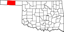 | |
| Towns | ||
| Unincorporated communities | ||
This article is issued from Wikipedia - version of the 7/31/2016. The text is available under the Creative Commons Attribution/Share Alike but additional terms may apply for the media files.