Azna, Lorestan
For the administrative subdivision, see Azna County.
| Azna ازنا | |
|---|---|
| city | |
|
Imamzadeh Zeid and Ghasem holy tombs | |
 Azna | |
| Coordinates: 33°27′21″N 49°27′20″E / 33.45583°N 49.45556°ECoordinates: 33°27′21″N 49°27′20″E / 33.45583°N 49.45556°E | |
| Country |
|
| Province | Lorestan |
| County | Azna |
| Bakhsh | Central |
| Population (2011) | |
| • Total | 41,706 |
| Time zone | IRST (UTC+3:30) |
| • Summer (DST) | IRDT (UTC+4:30) |

Azna (Persian: ازنا, also Romanized as Aznā and Eznā)[1] is a city in and capital of Azna County, Lorestan Province, Iran. At the 2011 census, its population was 41,706, in 11,594 families.[2]
Azna is located in the Zagros Mountains.
It currently serves as a refuge camp for the Faili Kurds.[3]
This township is located 133 km. east of Khoramabad and 75 km. south of Arak. It experiences cold winters and moderate summers. The city is en route Esfahan - Khuzestan and is connected to the railway network of the country.
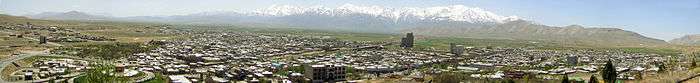
Panorama of Azna with the Zagros Mountains in the background
References
- ↑ Azna, Lorestan can be found at GEOnet Names Server, at this link, by opening the Advanced Search box, entering "-3054203" in the "Unique Feature Id" form, and clicking on "Search Database".
- ↑ "Census of the Islamic Republic of Iran, 1390 (2011)". Islamic Republic of Iran. Archived from the original (Excel) on 2016-10-06.
- ↑ "The Road Home: The Faili Kurds". Archived from the original on 2006-11-21. Retrieved 2006-12-25.
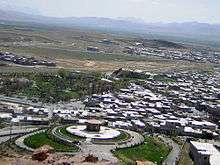

view from Southwest
External links
| Capital |  | ||||||||||||||||||||||||||||||||||||||
|---|---|---|---|---|---|---|---|---|---|---|---|---|---|---|---|---|---|---|---|---|---|---|---|---|---|---|---|---|---|---|---|---|---|---|---|---|---|---|---|
| Counties and cities | |||||||||||||||||||||||||||||||||||||||
| Sights |
| ||||||||||||||||||||||||||||||||||||||
| populated places | |||||||||||||||||||||||||||||||||||||||
This article is issued from Wikipedia - version of the 10/23/2016. The text is available under the Creative Commons Attribution/Share Alike but additional terms may apply for the media files.