Axochiapan
| Axochiapan | ||
|---|---|---|
| City | ||
| ||
| Coordinates: 18°30′N 98°45′W / 18.500°N 98.750°W | ||
| Country | Mexico | |
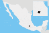
| State | Morelos | |
| Founded | 1542 | |
| Founded by | Fray Juan de Alameda | |
| Named for | "Water lily" or "pond flowers" for the lilies found on surrounding ponds. | |
| Government | ||
| • Mayor | Rodolfo Rodriguez Dominguez (PSD) | |
| Area | ||
| • Total | 172.935 km2 (66.771 sq mi) | |
| Elevation | 1,030 m (3,379.265 ft) | |
| Population (January 2010[1]) | 30,576 | |
| • Demonym | Axochiapense | |
| Time zone | Central Standard Time | |
| Website | www.axochiapan.gob.mx | |

Coordinates: 18°30′N 98°45′W / 18.500°N 98.750°W Axochiapan is a city in the Mexican state of Morelos. It stands at 18°30′N 98°45′W / 18.500°N 98.750°W, at a mean height of 1,030 metres above sea level.
The city serves as the municipal seat for the surrounding municipality of the same name. The municipality reported 30,436 inhabitants in the year 2000 census.
It is notable for the numbers of inhabitants that migrate north to the Minneapolis, Minnesota area.
Etymology
The origin of Axochiapan's name come from "axochi-tl", which means “water flower or water lily”. This comes from the many white lilies that form like carpets on the ponds and lakes in the area.
Shield
The shield's appearance is due to the water lilies that are prevalent in the area. Its peeking out of the water conveys how, just like in real life, they rapidly grow and reproduce in water.
History
Axochiapan is a city with ancient Olmec and Tlahuican origins. They were dominated by the Aztec Empire. With the Spanish conquest, the village stopped paying tribute to the Aztec Empire and came under the rule of the Spanish Crown.
Axochiapan belonged to the municipality of Jonacatepec from 1824 to 1869. Later, the State of Morelos was created, which also created the municipality of Tetelilla. From 1869 to 1898, Axochiapan belonged to Tetelilla until it finally became its own municipality, covering territory that previously belonged to Tetelilla (with exception to a city which was integrated with Jonacatepec).
On November 9, 1898, Axochiapan's first town hall was installed. With its installation, the town's first mayor, Luis G. Rebolledo, went into office.
Connections to the Mexican Revolution
During the Mexican Revolution, Axochiapan was not untouched. Members from the Liberation Army of the South such as Alejandro Casales, Joaquín Caamaño, Marcelino Rodríguez, Marcelino Vergara, Benigno Abundes and José Palma had connections to the city. There were many people who participated in the revolution, and the following are just a few.
General Alejandro Casales
Casales was one of the most important leaders during the Mexican Revolution. He fought in rebel operations in Morelos and helped organize peasant resistances.
On March 11, 1911, peasants in Morelos took up arms in Ayala. Directed by Pablo Torres Burgos, they headed south to take Tlalquiltenango and Jojutla. When Burgos failed to control his men, he resigned from their command. After he left, he was captured and executed by his enemies. This left Casales to organize the soldiers. Soon, forces under the command of Morelos Cuernavaca and the 18th regiment under the control of Colonel Javier Rojas began to search for Casales.
It wasn't long before the 18th Regiment found Casales. He fought heroically all day until he was finally caught and burned alive. However, he had left Axochiapan organized to be the background for a new municipality.
General José Palma
Palma was born in Axochiapan; in 1911 he joined the Zapatista movement. He fell in battle, and his body was never found.
General Marcelino Rodríguez
Marcelino Rodríguez was from San Pablo in Tlaltizapán. He acted with military forces inside the borders of Morelos. He was an officer under the orders of General Francisco Mendoza, acting as the head of his escorts and later as the colonel of his own guerrilla group.
General Benigno Abundes
Originally from Axochiapan, he fought under the orders of General Lorenzo Vázquez. On August 30, 1911, when Emiliano Zapata broke with the group, Abundes took control of his troops. He and continued battling in Tilzapotla, Los Hornos, Nexpa, Quetzalpa, Chaucingo and San Miguel in the state of Guerrero.
Joaquín Camaño Pérez
Born in Axochiapan in 1887, Joaquín was the son of Martín Camaño and Petra García Sánchez. He began fighting at a very young age because he was angered by injustice. His scope included Jonacatepec to Chietla in the state of Puebla. He united with General Francisco Mendoza's forces and was in the contingent that accompanied the General Emiliano Zapata in Chinameca where he was assassinated.
Important Dates
- 1542: Fray Juan de Alameda, in the name of King Carlos V, founds the town and calls it San Pablo de Axochiapan.
- 1869: Axochiapan integrates with the municipality of Santo Tomás of Tetelilla.
- 1887: Axochiapan installs its first chapter with Don Luis G. Rebolledo as the president.
- 1996: Axochiapan celebrated its 450th anniversary since its foundation of its population in Tlahuican culture.
Location
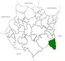
Axochiapan is located at 18°30’ N and 98°45’ W at an altitude of 1,030 meters above sea level. It is bordered at the north with the municipality of Jonacatepec, to the south and east with the state of Puebla, and to the east with the municipality of Tepalcingo.
Environment
Area
The city has an area of 172,935 square kilometers, representing 3.49% of the state's total.
Topography
Axochiapan is located in a valley crossed by ravines. Its ground is hard to work with, and its geologic structure is that of large sediments, conglomerate rocks, and sands of various grades. The area is hilly near the southeast end of town, and those hills make up approximately 12.2% of the city. Axochiapan is mostly flat in its other areas.
Hydrography
The city's main water resources are mainly made up of the Amatzinac River and the Tenango River which cross the city. There are the gullies named Tochatlaco, Los Ahuhuetes, and El Pajarito. The Carros and Cayehuacan dams allow the city to use the water from the San Francisco River Tributary from the Nexpa River The water benefits more than 1,000 families, supports 45 deep wells, and is also used for agriculture.
References
- ↑ "Censo de Población y Vivienda 2010". http://www.inegi.org.mx/. National Institution of Statistics and Geography. Retrieved 7 November 2014. External link in
|website=(help)